PLANTAE / PHANEROGAMAE / ANTHOPHYTA / ASPARAGALES / ASPHODELACEAE / ALOOIDEAE / HAWORTHIA / COOPERI / PILIFERA

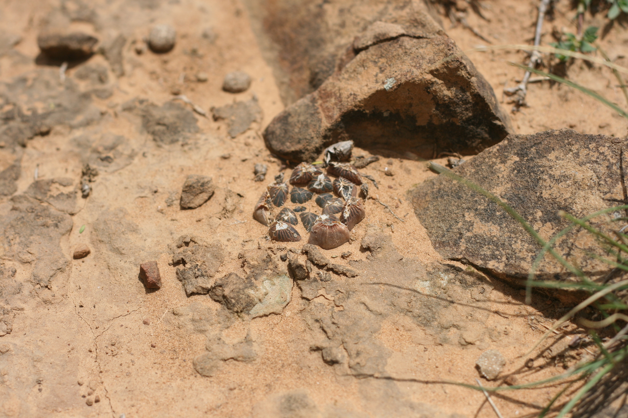
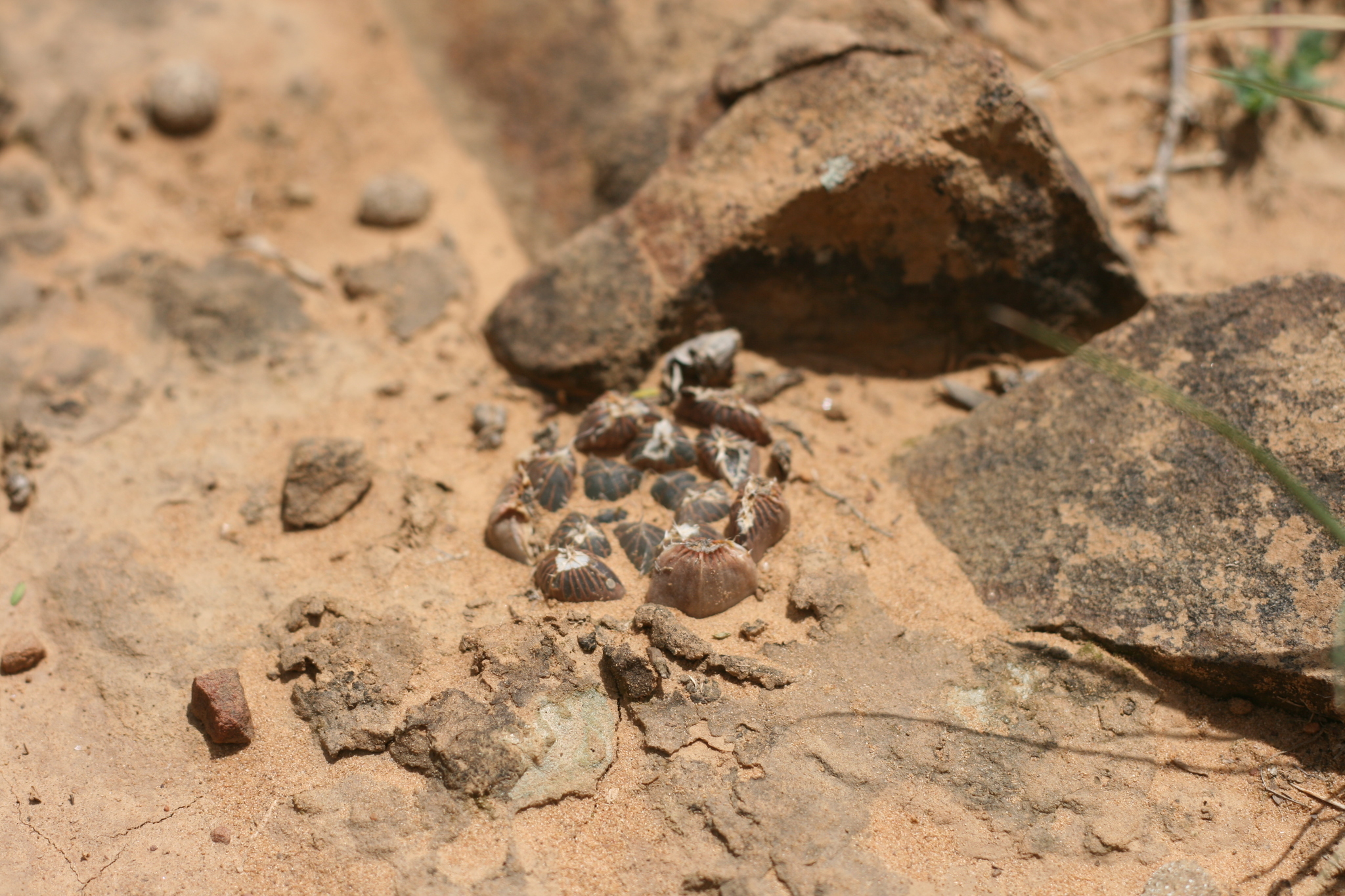
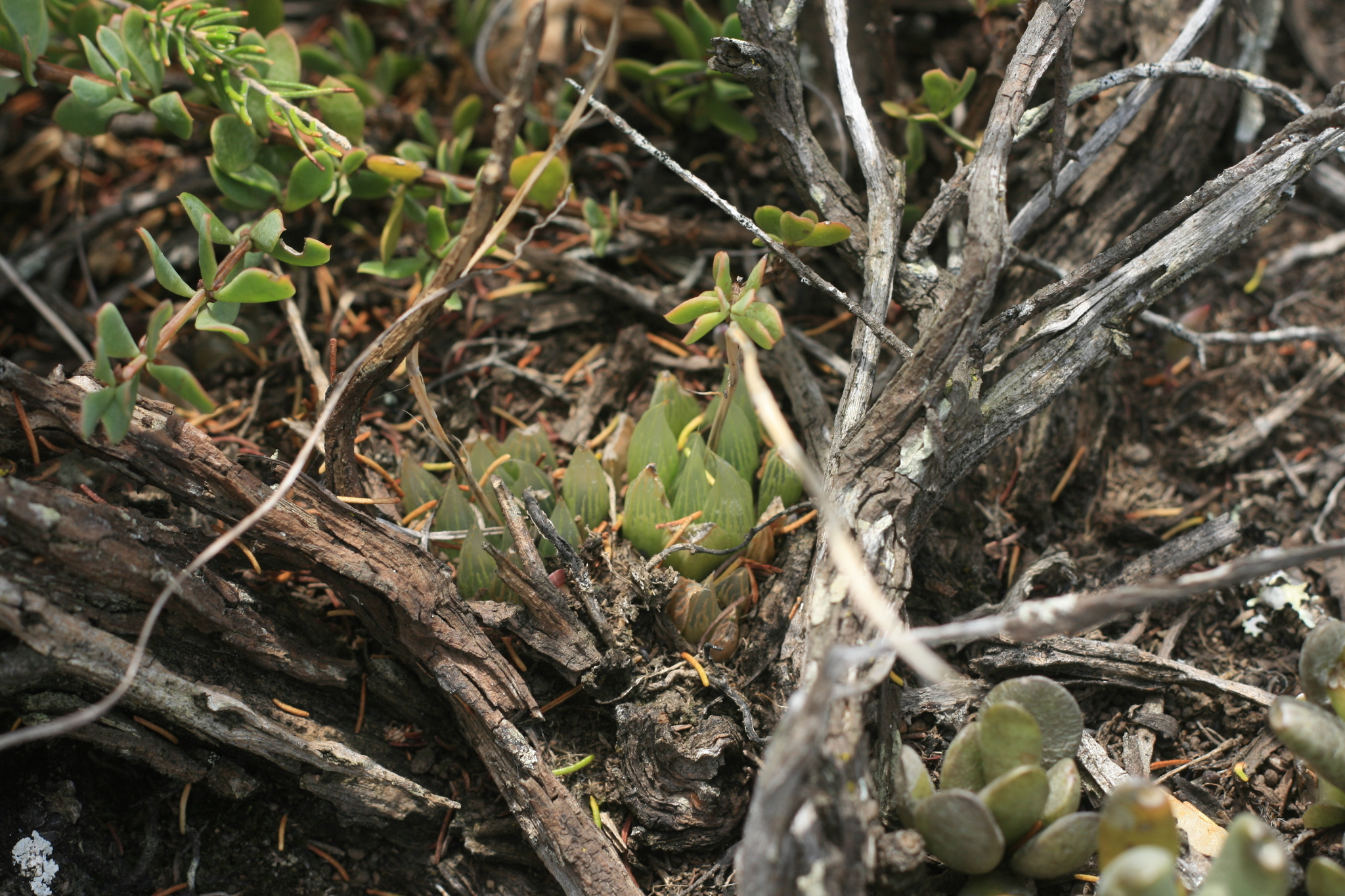
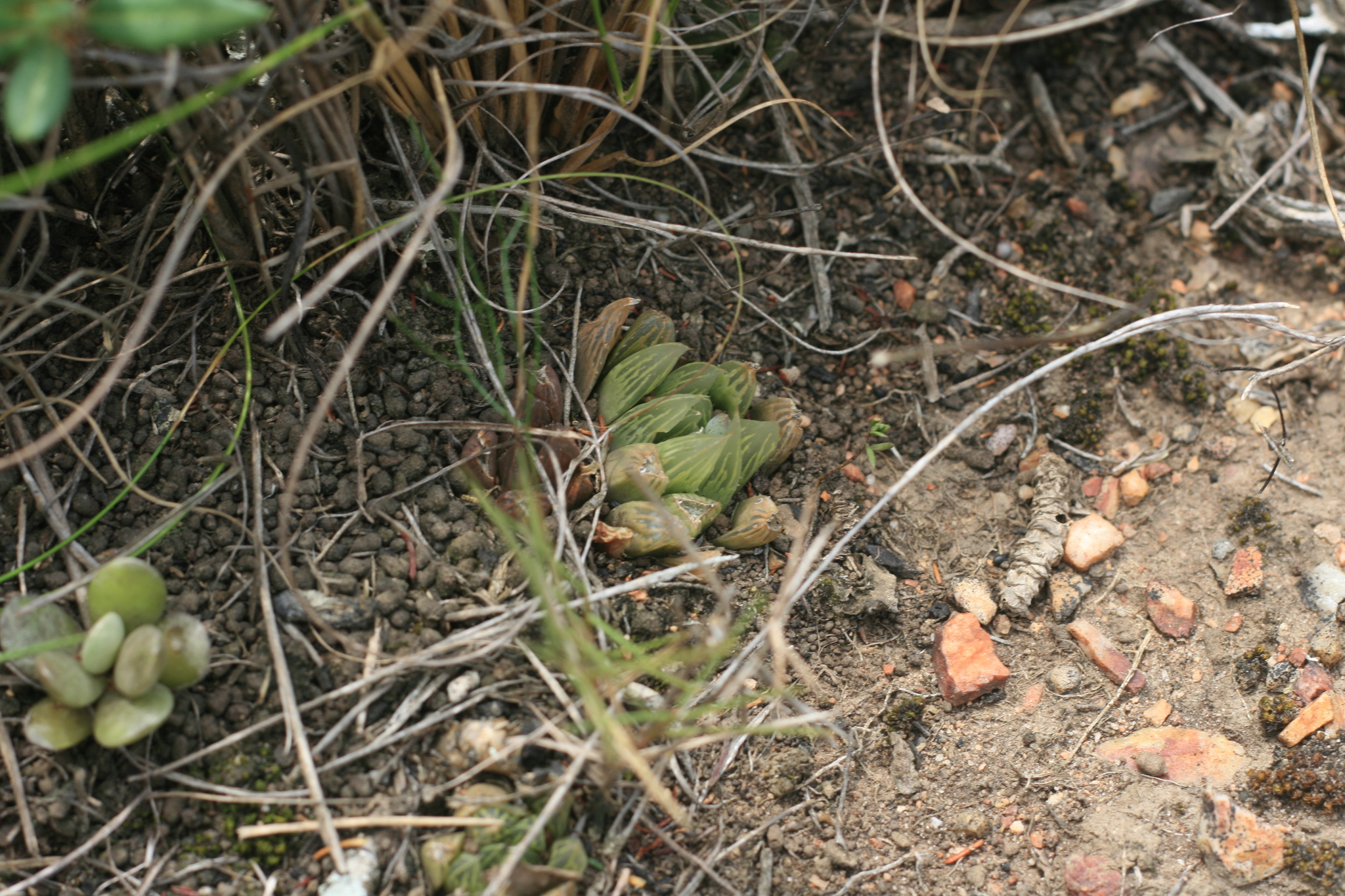
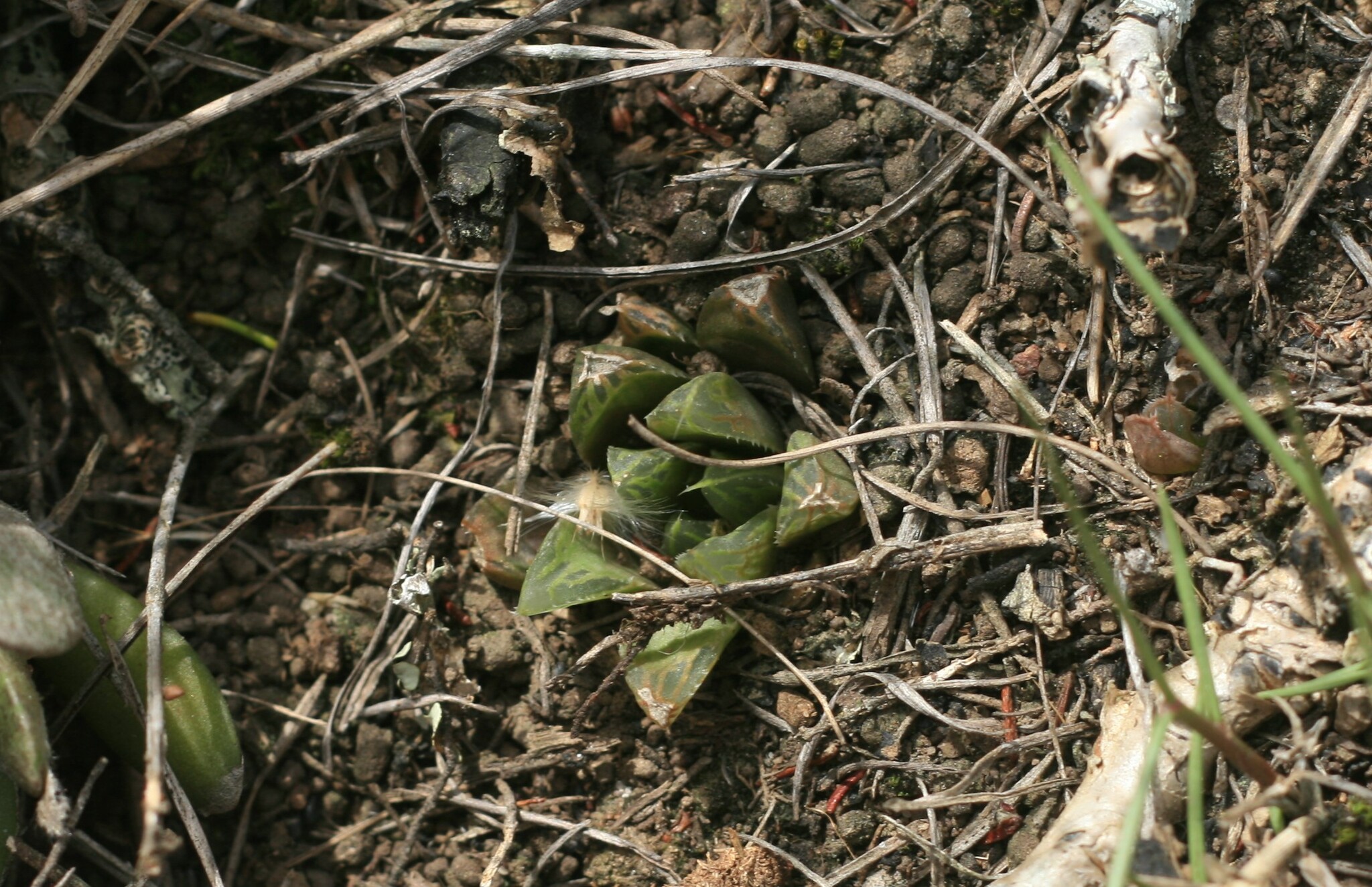
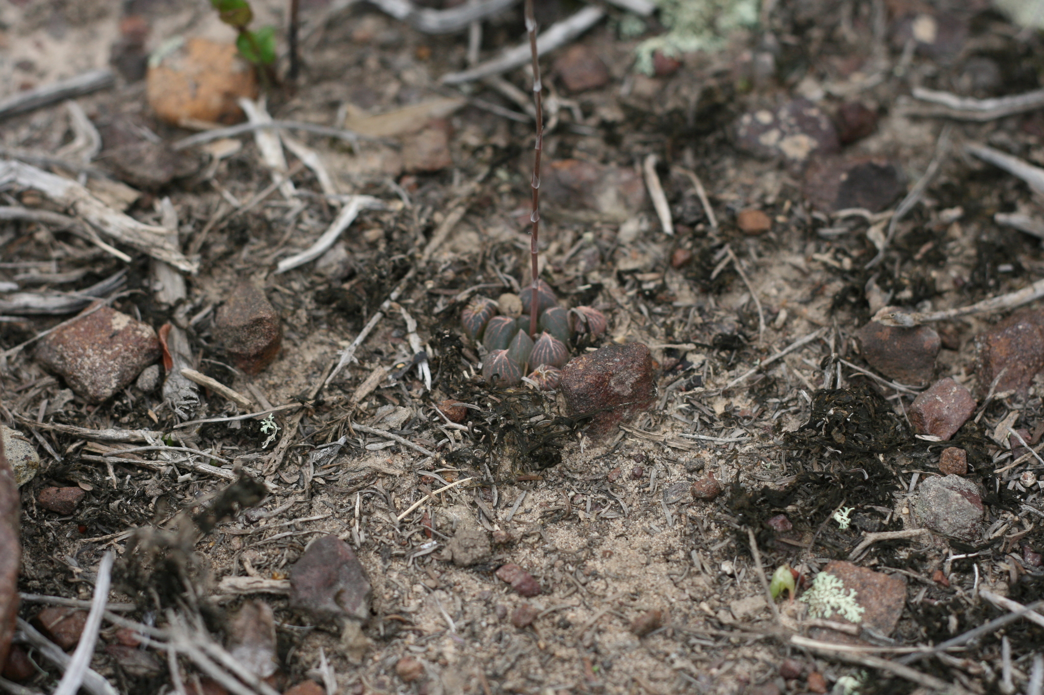
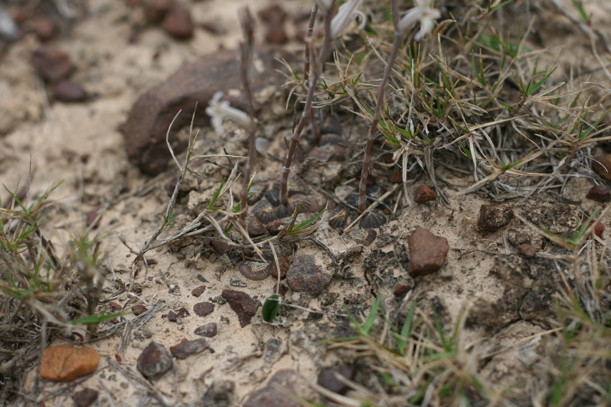
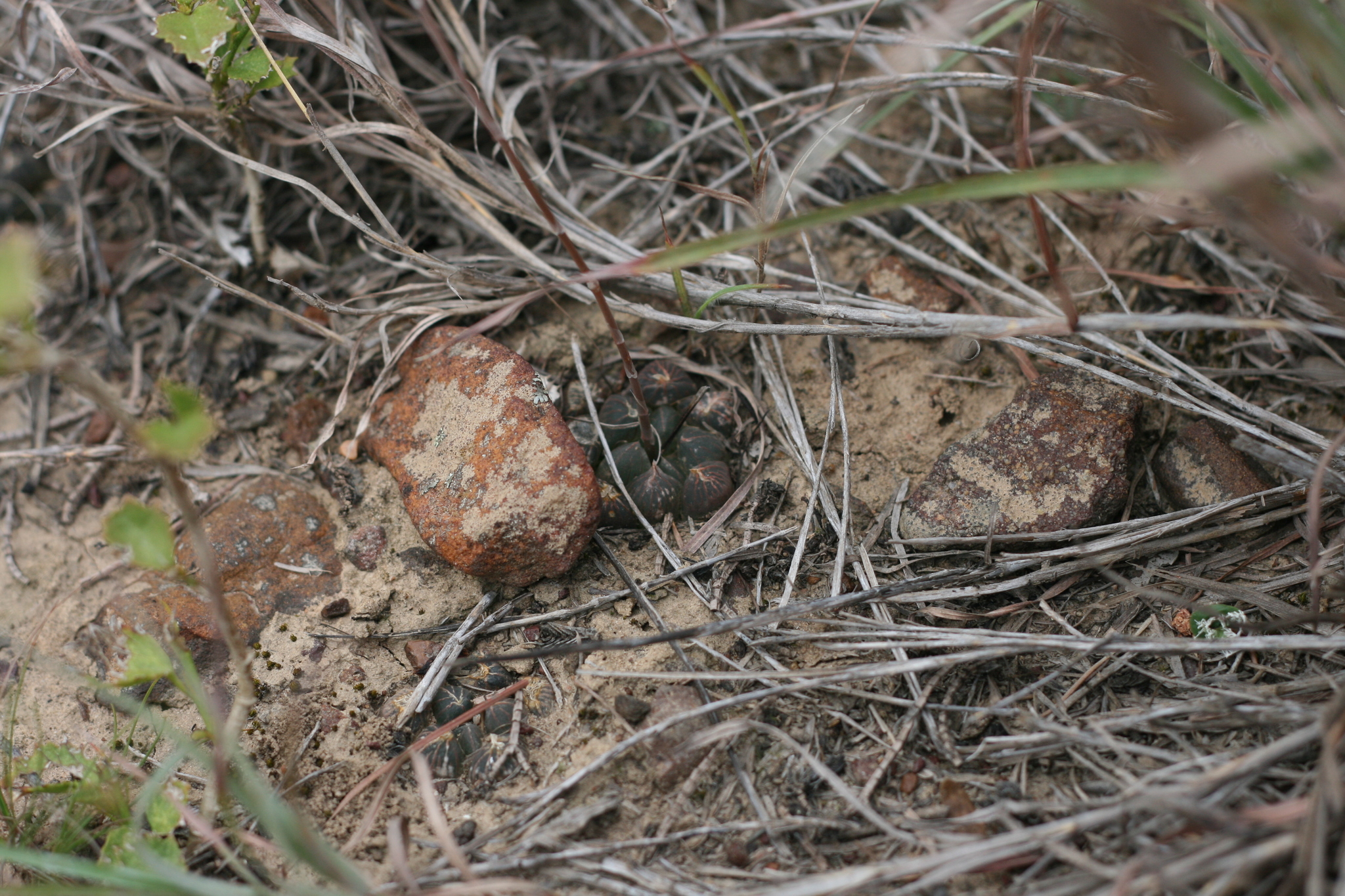
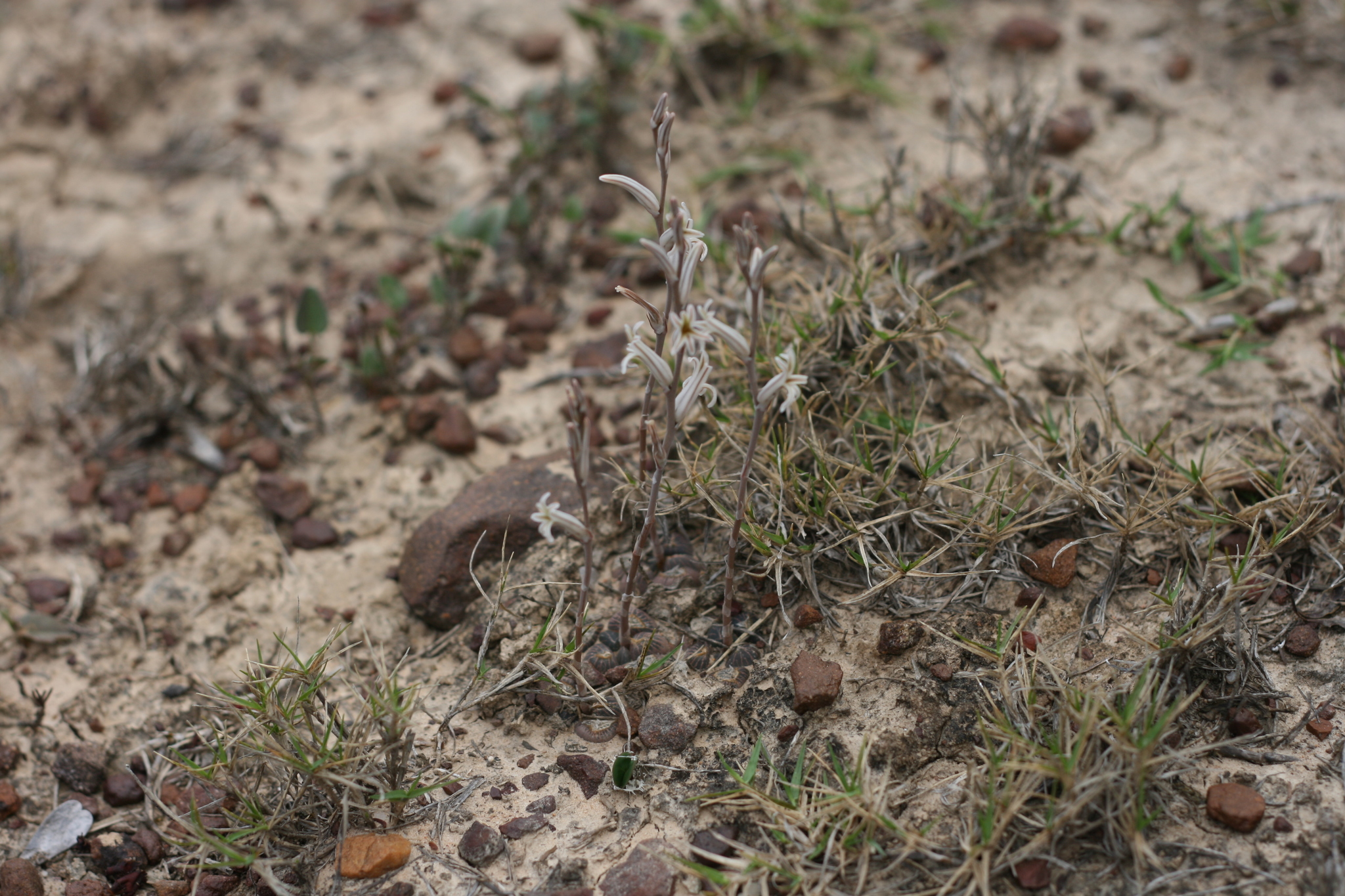
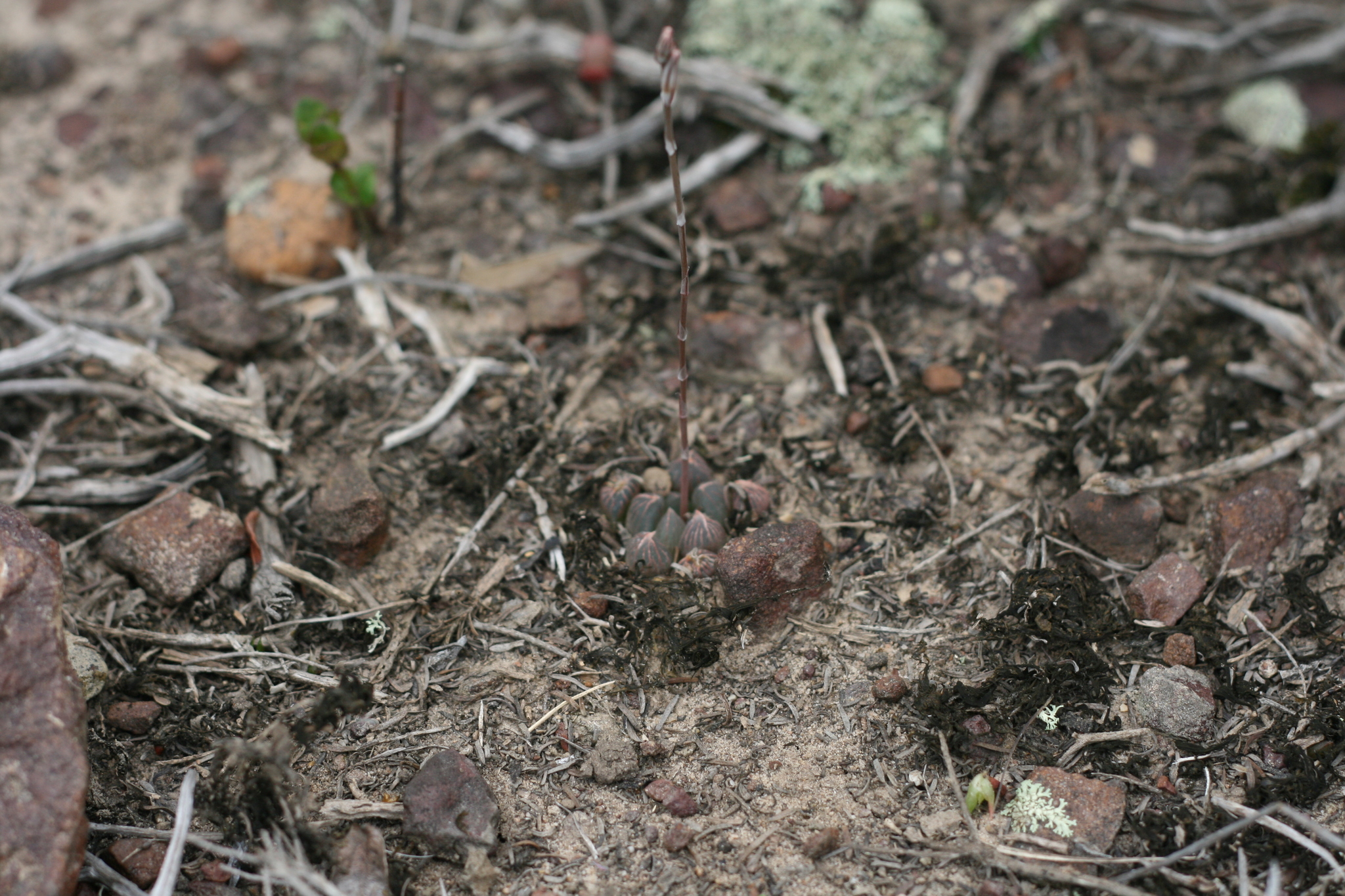
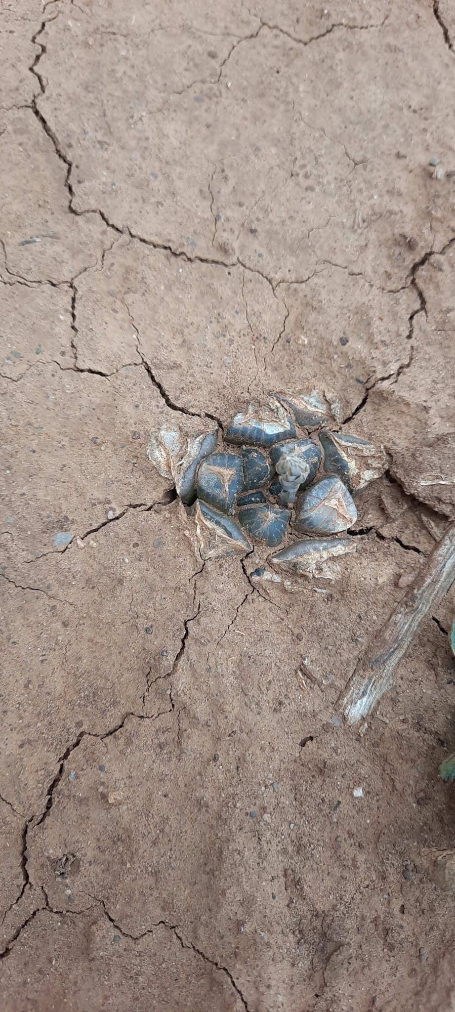
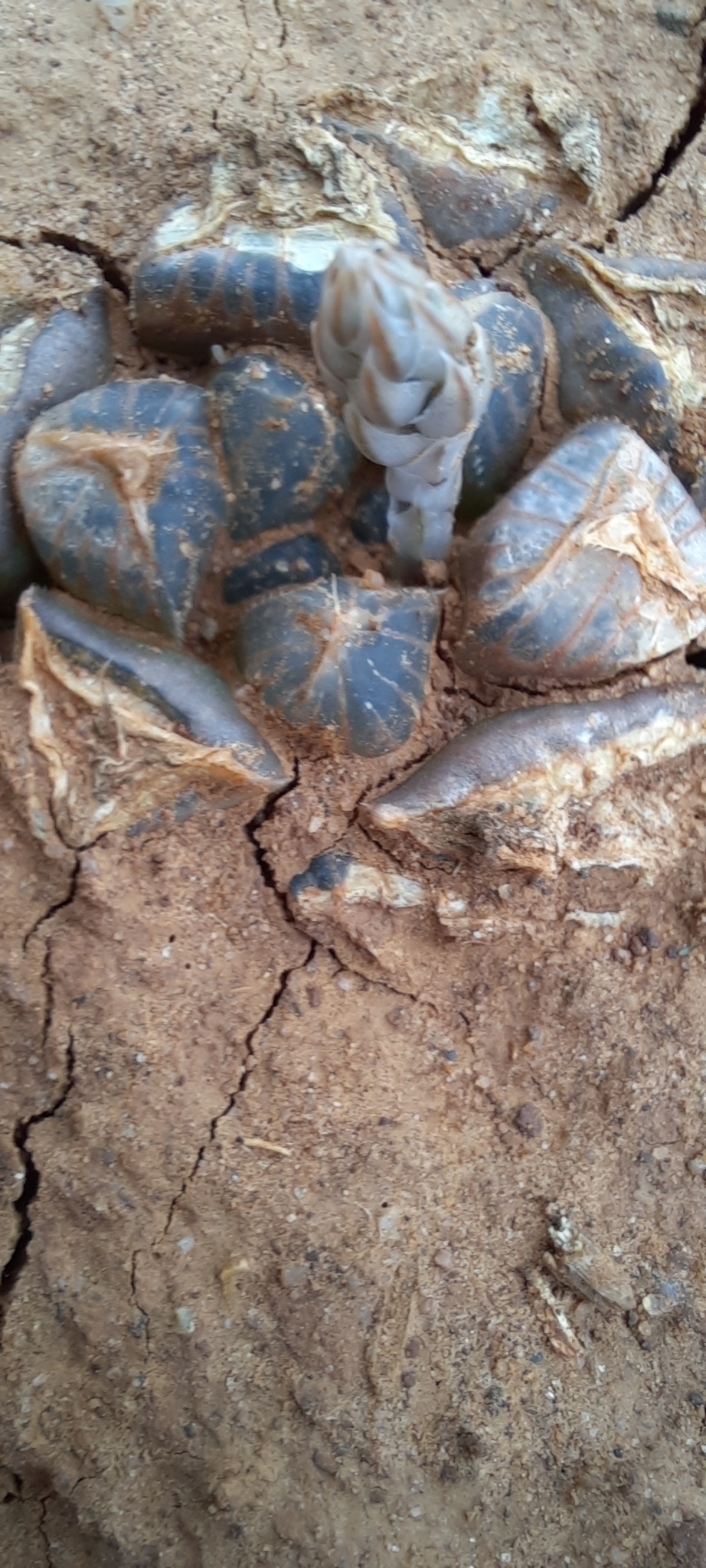
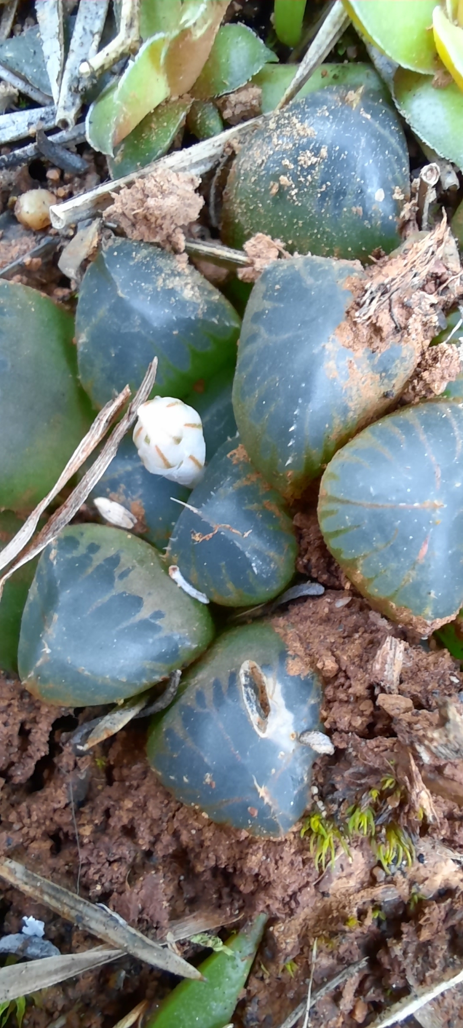
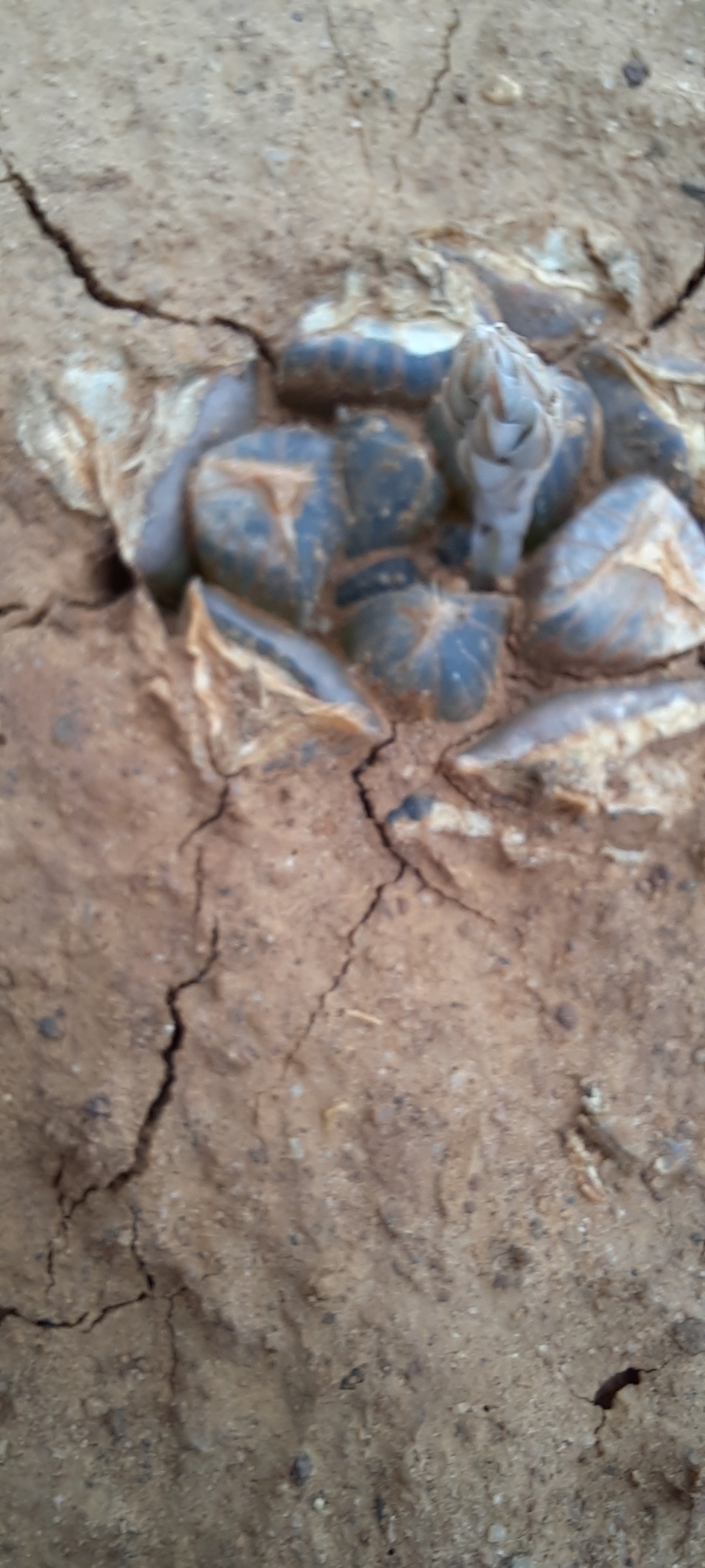
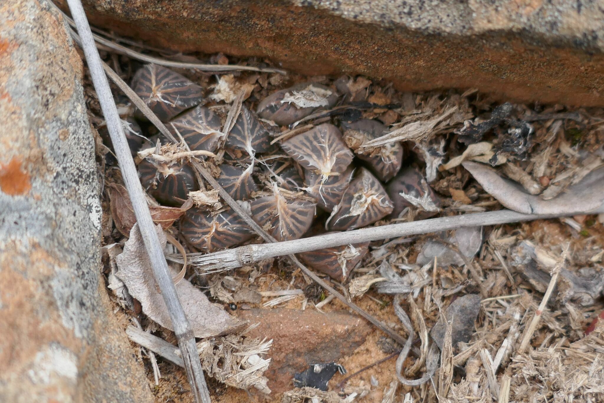
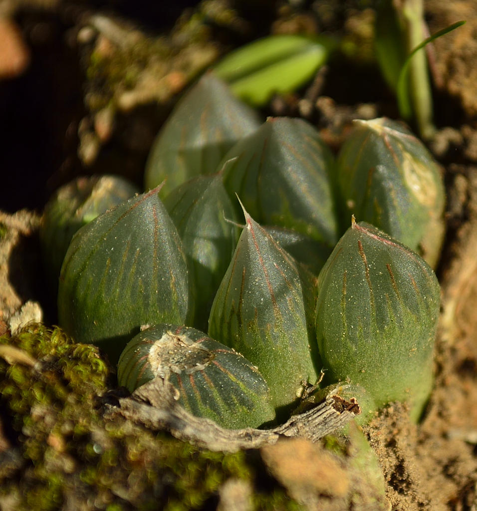
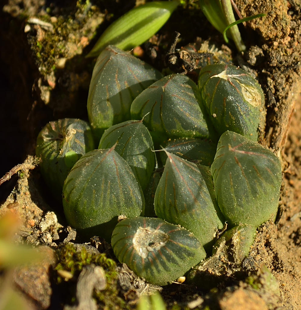
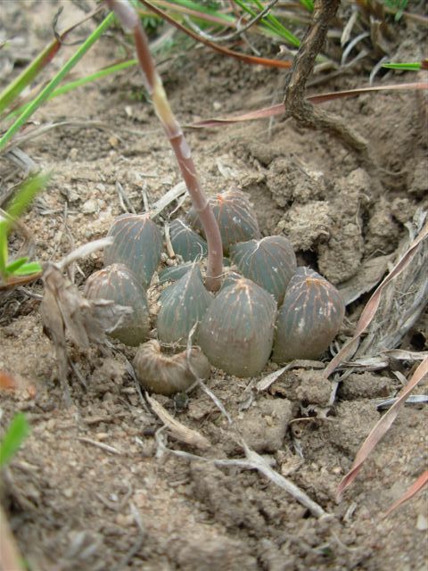
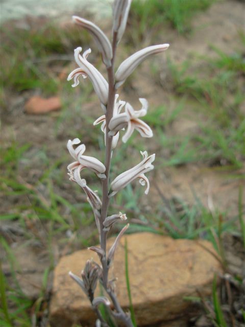
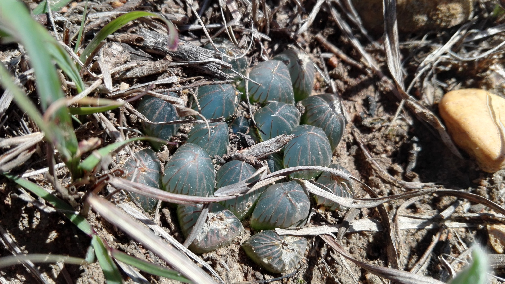
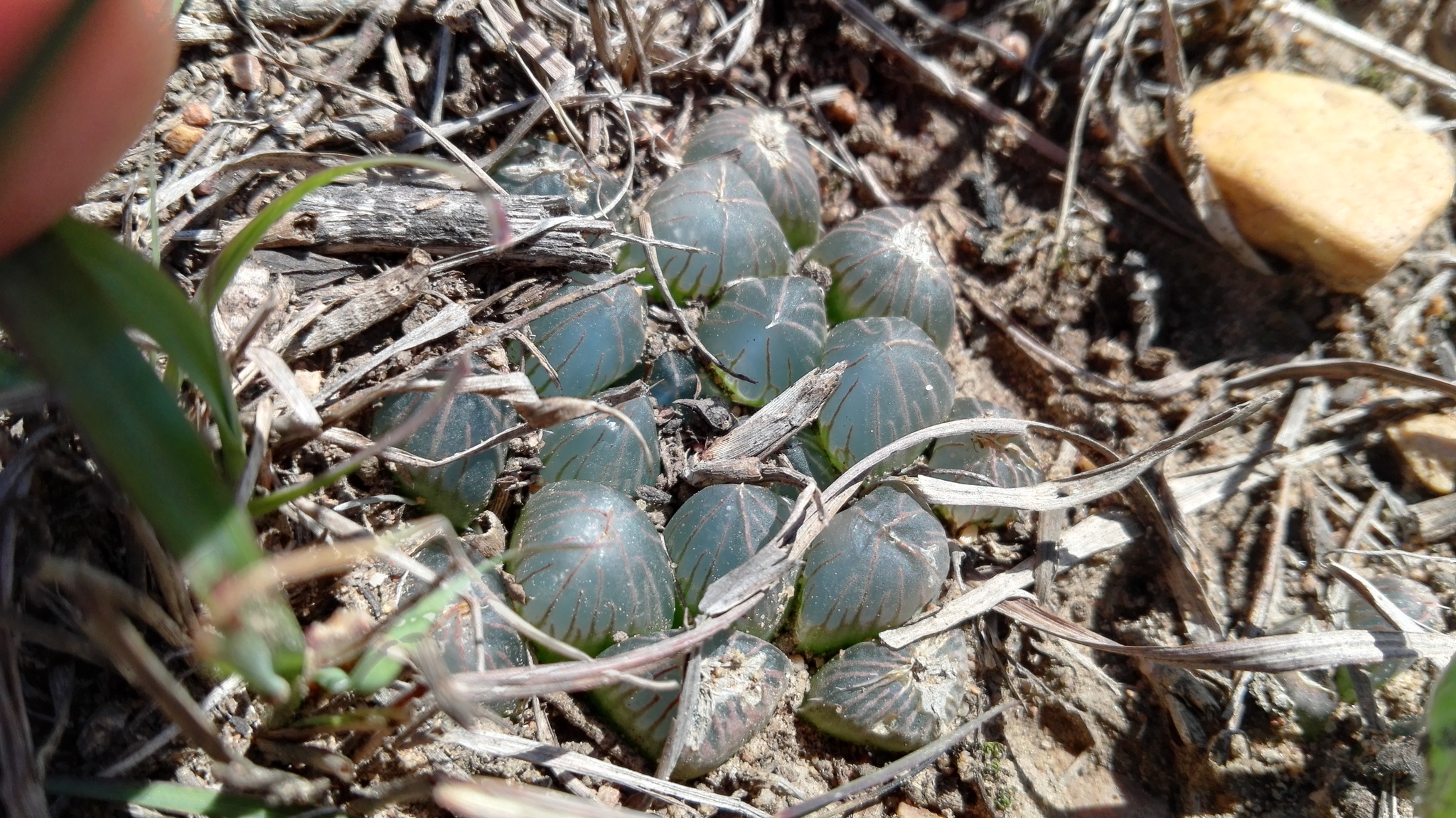
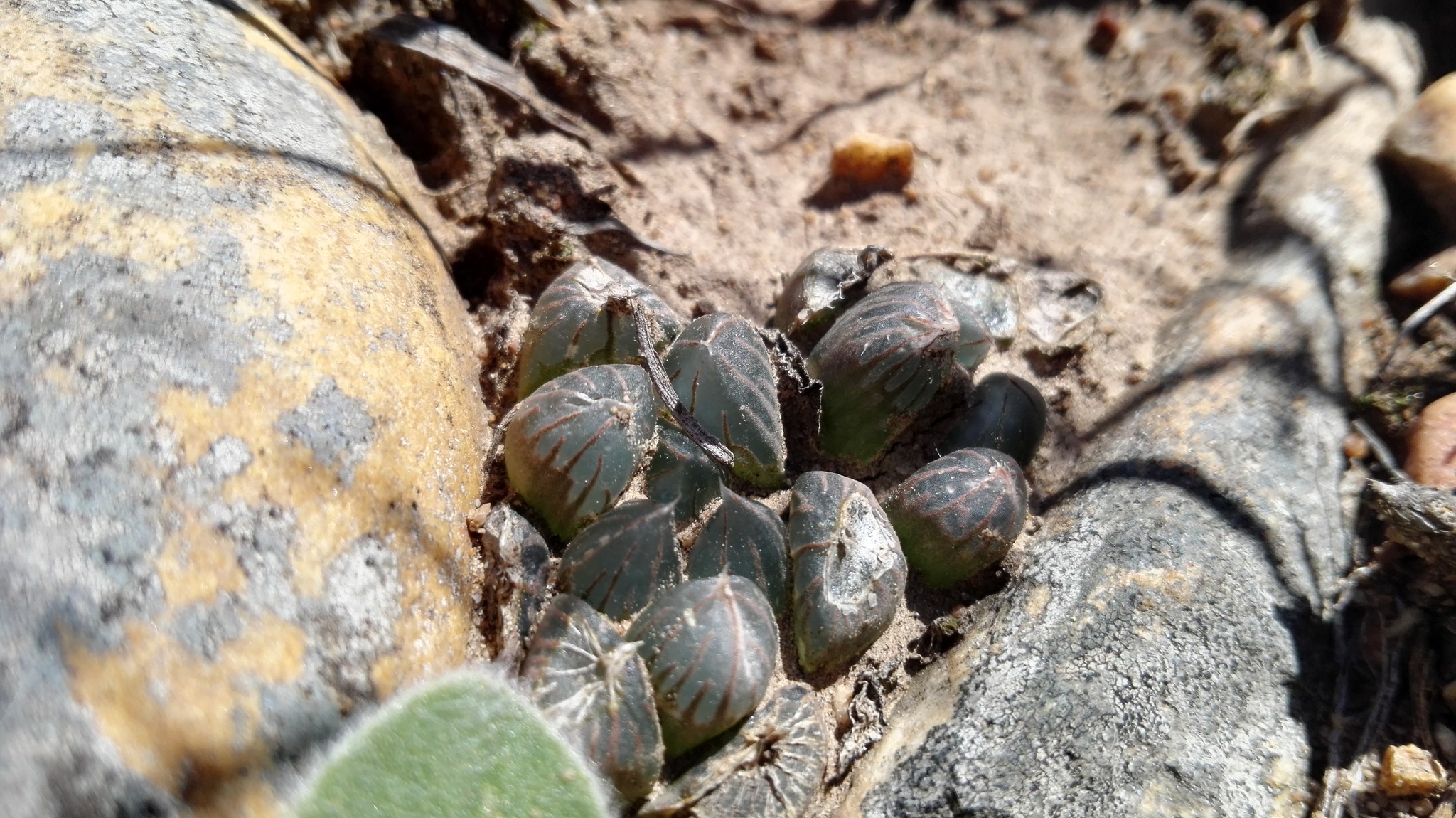
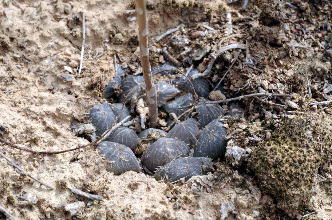
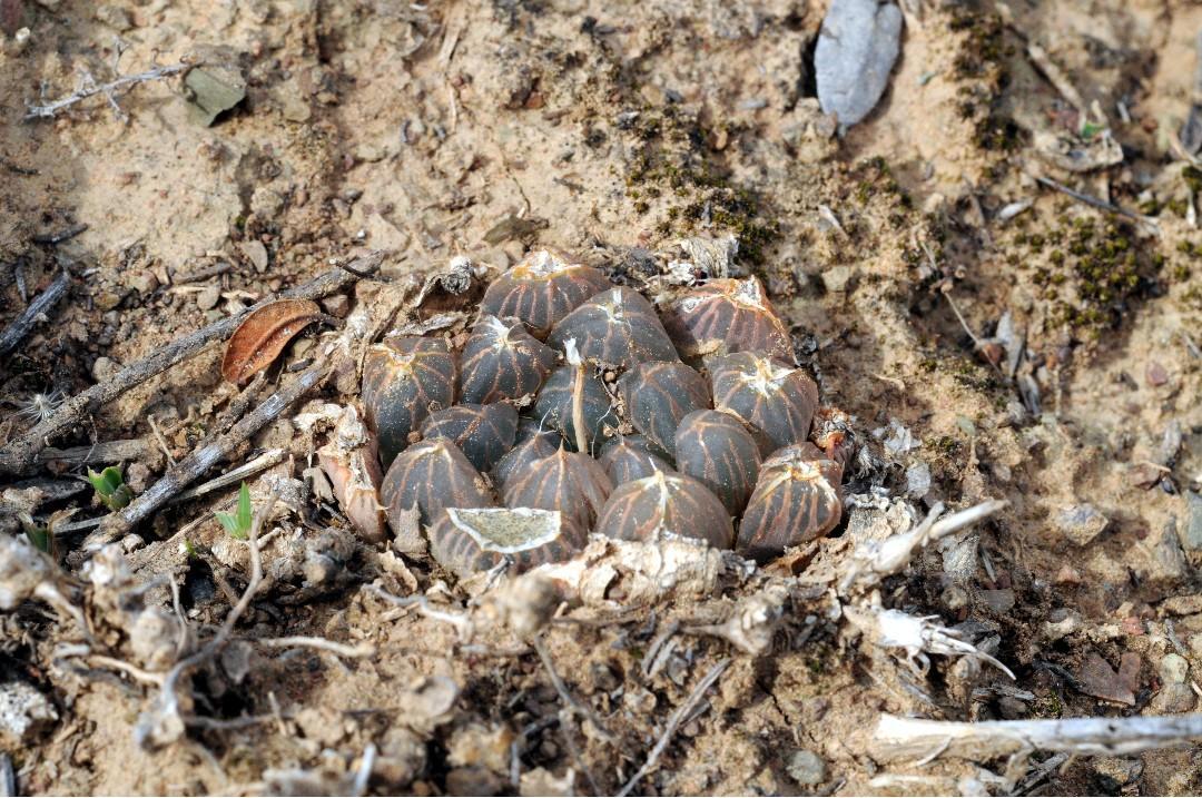
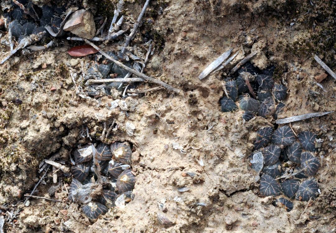
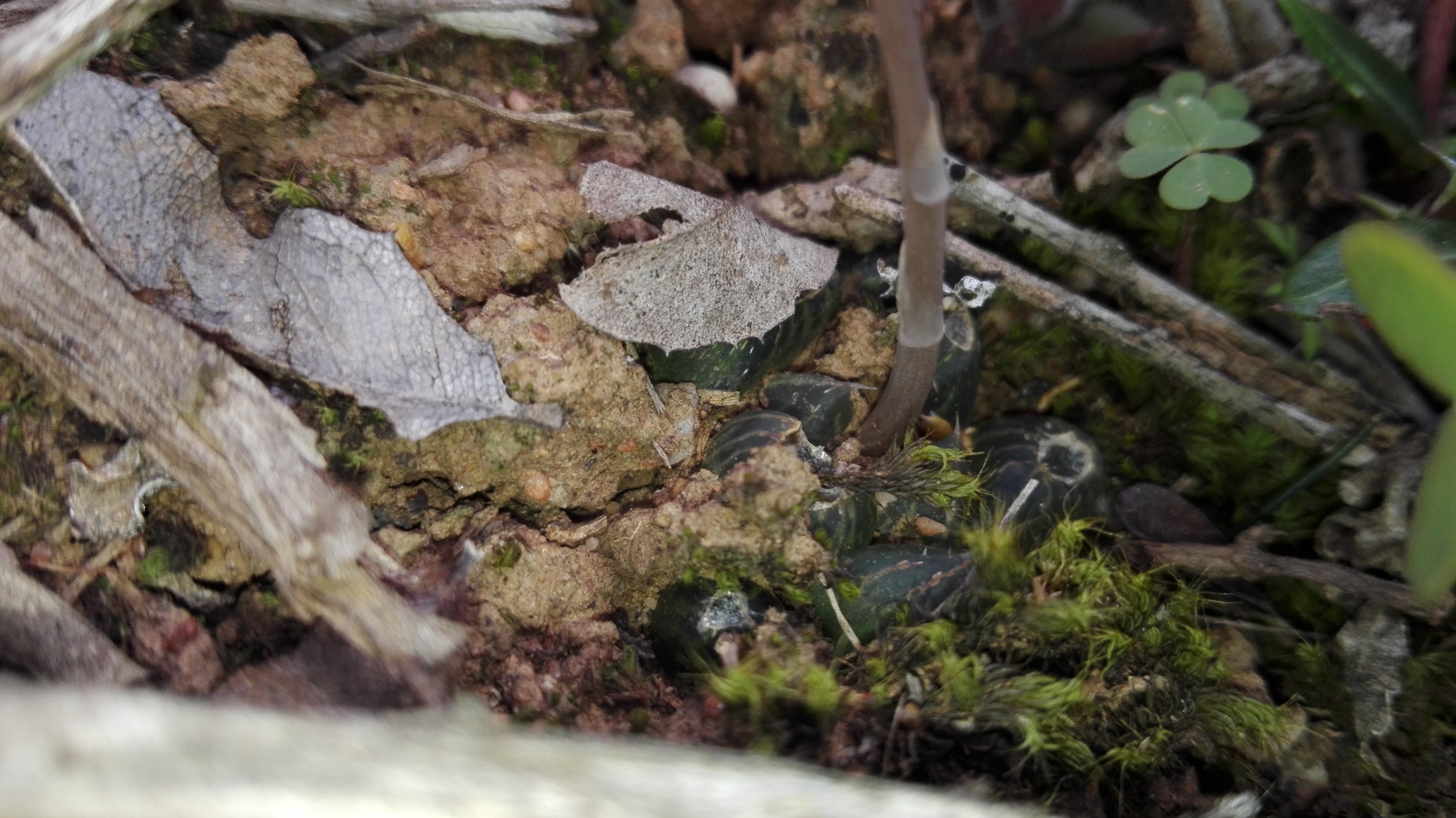
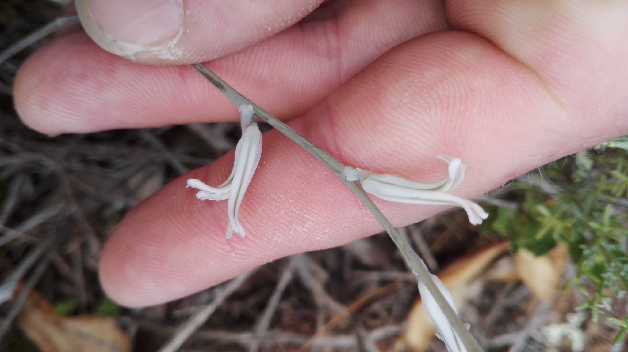
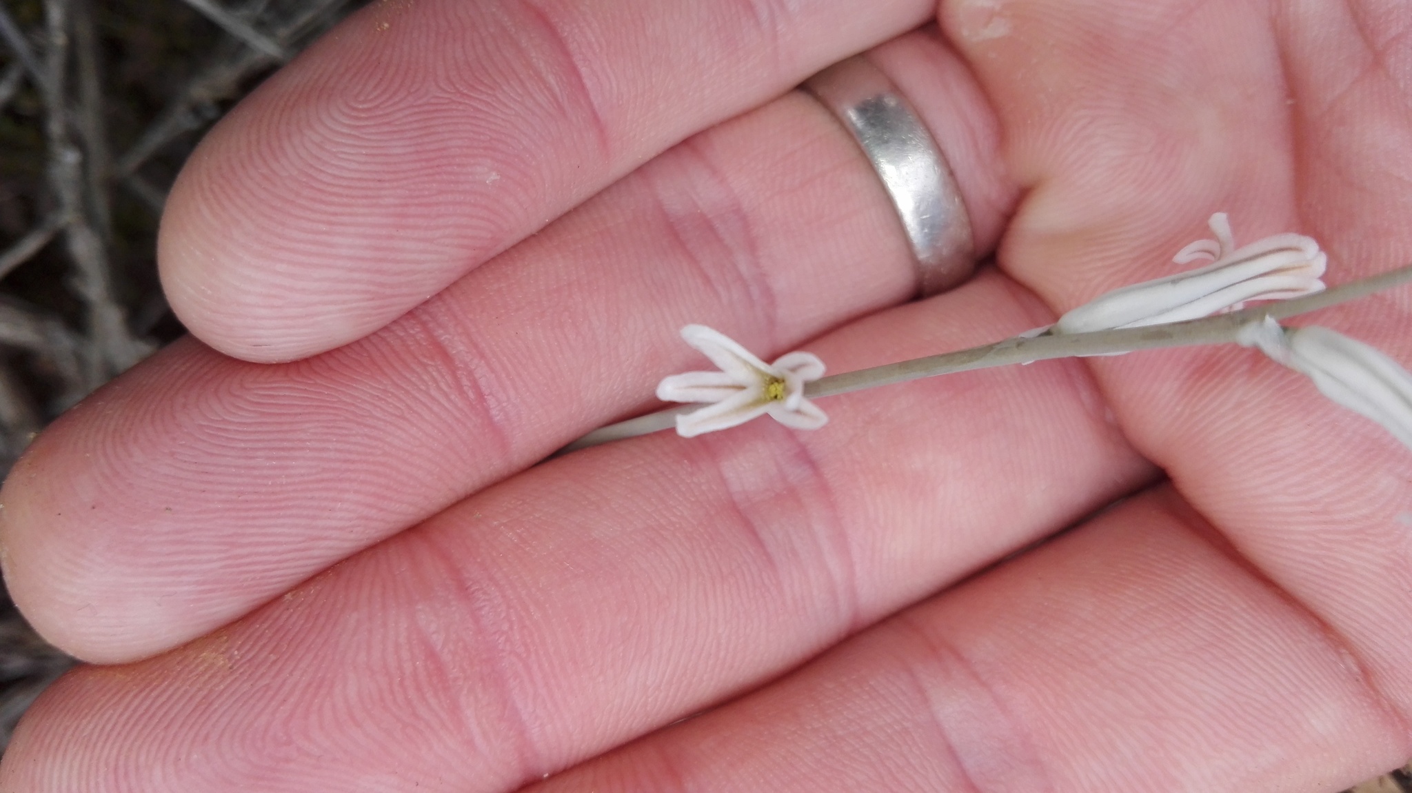
Plants acaulescent, in a basal rosette about 40 mm diam., proliferous from the base and forming clusters. Leaves green to reddish-brown, the young erect, tips incurved, the old ascending, erect, 20 to 25 mm long, up to 13 mm broad, up to 6 mm thick, elongate to lanceolate, or ovate lanceolate; upper surface convex, smooth, turgid near the apex, the pellucid part about 12 mm long, distinctly separated from the lower green, with about 6 reddish or green longitudinal lines; lower surface convex, smooth, with 10 longitudinal reddish-brown or green lines; keel 1, centrally positioned, toothed with about 1.5 mm long scattered teeth; margins rounded from the tip to about the middle, acute below, with a single row of 1.5 mm long teeth visible from the upper third to the base of the leaf, the upper smooth; end-awn about 5 mm long, sparsely denticulate. Inflorescence about 360 mm tall; peduncle simple, terete, 2 mm diam., about 160 mm long, bracteate; sterile bracts membranous, ovate to acuminate, about 6 mm long, erect, keeled; raceme about 200 mm long, lax, with about 20 spirally arranged flowers and buds, 4 open simultaneously; floral bracts membranous, 6 mm long, deltoid, keeled with fine reddish-brown veins, clasping the pedicels, (longer than the pedicels); pedicels 4 mm long, 1 mm diam., green, erect; perianth white with light green or reddish-brown veins to the segments, 13 mm long, compressed at base, funnel-shaped, tube more or less 4 mm across, constricted to 3 mm above, curved; segments free to the base, limb 2 lipped; posterior segments obtuse, channelled, little recurved, little spreading, white with reddish-brown veins; exterior part obtuse, channelled, little recurved, spreading, white with brown veins; stamens 6 of two lengths, 5 and 6 mm long, inserted within the perianth tube; ovary 5 mm long, 2 mm diam., green; style 2 mm long, curved, capitate. From: Scott, CL. 1985. The genus Haworthia (Liliaceae): a taxonomic revision. Aloe Books, Johannesburg. [All rights reserved] As: Haworthia pilifera Baker
H. pilifera presents an interesting parallel to H. cymbiformis var. obtusa and H. altilinea, both the latter species also being endemic to the eastern Cape Province. The characters common to the three species are the oblong leaves with more or less rounded and swollen leaf-tips and numerous back and face lines. H. pilifera differs from H. cymbiformis var. obtusa by the pellucid area not being irregularly separated from the lower opaque green areas; and it has a longer inflorescence, with different floral characters. From H. altilinea it differs in that the teeth on the margins and keel are long, there is no raised line on the upper side of the leaves, it has a longer inflorescence with more flowers and also has different floral characters, but there is no difference in their flowering time. From: Scott, CL. 1985. The genus Haworthia (Liliaceae): a taxonomic revision. Aloe Books, Johannesburg. [All rights reserved] As: Haworthia pilifera Baker
It grows mainly in short grassland, but is sometimes found in open Acacia savanna. In drier localities it may be associated with Aloe spp. The annual summer rainfall varies between 500 and 750 mm. The summers are hot and winters cold, often with snow on the surrounding mountains. H. pilifera prefers a firm hard soil with pH 5.6. From: Scott, CL. 1985. The genus Haworthia (Liliaceae): a taxonomic revision. Aloe Books, Johannesburg. [All rights reserved] As: Haworthia pilifera Baker
H. pilifera is endemic to the eastern Cape Province. From: Scott, CL. 1985. The genus Haworthia (Liliaceae): a taxonomic revision. Aloe Books, Johannesburg. [All rights reserved] As: Haworthia pilifera Baker
This map contains point-based occurrences at different locations
Occurrence in the Flora of Southern Africa (FSA) countries and South African provinces. Residence status indicates if a taxon is indigenous, endemic, naturalised or invasive in a specific region. This data is based on specimen records and literature
FSA
SA
BOT
NAM
ESW
LES
WC
EC
NC
FS
GA
KZN
LP
MP
NW
Absent
Indigenous
Endemic
Naturalised
Invasive

Names and Sources
Published in: Haworthia Revisited: 54 (1999)
Iconotype: Refug. Bot.:234 (1871)
Haworthia pilifera Baker
Published in: Refug. Bot. [Saunders]: t. 234 (1871)
Haworthia obtusa Haw. var. pilifera (Baker) Uitewaal
Published in: Succulenta (Netherlands) 29: 50 (1948)
Haworthia stayneri Poelln., as 'staynerii'
Published in: Repert. Spec. Nov. Regni Veg. 42: 270 (1937)
Haworthia stayneri Poelln. var. salina Poelln.
Published in: Repert. Spec. Nov. Regni Veg. 42: 271 (1937)
Haworthia pilifera Baker var. salina (Poelln.) Poelln.
Published in: Repert. Spec. Nov. Regni Veg. 44: 237 (1938)
Haworthia pilifera Baker var. stayneri (Poelln.) Poelln.
Published in: Repert. Spec. Nov. Regni Veg. 44: 237 (1938)
Haworthia pilifera Baker var. dielsiana (Poelln.) M.B.Bayer f. acuminata Poelln.
Published in: Repert. Spec. Nov. Regni Veg. 49: 27 (1940)
Haworthia obtusa Haw. var. dielsiana (Poelln.) Uitewaal f. acuminata (Poelln.) Uitewaal
Published in: Succulenta (Netherlands) 29: 50 (1948)
Haworthia obtusa Haw. var. salina (Poelln.) Uitewaal
Published in: Succulenta (Netherlands) 29: 50 (1948)
Haworthia obtusa Haw. var. stayneri (Poelln.) Uitewaal
Published in: Succulenta (Netherlands) 29: 50 (1948)
Haworthia luri M.Hayashi, nom. inval.
Published in: Haworthia Study 14: 11 (2005)
Type: South Africa, Addo, M.Hayashi 03-448 (herbarium not specified)
Haworthia salina (Poelln.) M.Hayashi
Published in: Haworthia Study 22: 11 (2010)
Classification
KINGDOM Plantae
SUBKINGDOM Phanerogamae
PHYLUM Anthophyta
ORDER Asparagales
FAMILY Asphodelaceae
SUBFAMILY Alooideae
GENUS Haworthia
SPECIES cooperi
VARIETY pilifera
97 results for Haworthia cooperi Baker var. pilifera (Baker) M.B.Bayer
Year
Barcode: NBG0068764-0 Collector(s) & number: Joho, J, Smith 5342 | 1942-7-
South Africa, Eastern Cape, King William's Town Dist. Near Middledrift, on west side of river.
Data Resource: BODATSA View record
Barcode: PRE0036442-0 Collector(s) & number: Marloth, HWR, 13133 | 1927-10-14
South Africa, Eastern Cape, UITENHAGE DIV.; DESPATCH
Data Resource: BODATSA View record
Barcode: NBG0112129-0 Collector(s) & number: Smith, GG, 5817 | 1945-2-
South Africa, Eastern Cape, Port Elizabeth. Bethelsdorp salt pan. (= type locality).
Data Resource: BODATSA View record
Barcode: NBG0274727-0 Collector(s) & number: Smith, GG, 283 | --
South Africa, Eastern Cape, Keiskamma Causeway.
Data Resource: BODATSA View record
Barcode: NBG0068903-0 Collector(s) & number: Archer, Smith 7350 | 1950-4-
South Africa, Eastern Cape, King Williamstown Dist. Keiskammahoek, on grassy slopes above rocky outcrop.
Data Resource: BODATSA View record
Barcode: NBG0274827-0 Collector(s) & number: Unknown, KG 389/70 | --
South Africa, Eastern Cape, 3 miles N of King William's Town. Balasi.
Data Resource: BODATSA View record
Barcode: NBG0111983-0 Collector(s) & number: Smith, GG, 5628 | 1943-9-
South Africa, Eastern Cape, Albany Dist. About 5 miles from Grahamstown on Cradock road.
Data Resource: BODATSA View record
Barcode: NBG0118797-0 Collector(s) & number: Smith, GG, 3513 | --
South Africa, Eastern Cape, King William's Town.
Data Resource: BODATSA View record
Barcode: NBG0274825-0 Collector(s) & number: Unknown, KG 382/70 | --
South Africa, Eastern Cape, Brigadoor, 10 km SE of Kei Road.
Data Resource: BODATSA View record
Barcode: NBG0118793-0 Collector(s) & number: Smith, GG, 5065 | --
South Africa, Eastern Cape, North of Grahamstown. The Fort.
Data Resource: BODATSA View record
Barcode: NBG0068381-0 Collector(s) & number: Compton, W, N.B.G. 1096/28 | 1943-6-9
South Africa, Eastern Cape, King William's Town Dist. King William's Town.
General notes: Hort. Kirstenbosch. Rockery.
Data Resource: BODATSA View record
Barcode: NBG0118811-0 Collector(s) & number: van Ryneveld, WA, Fourcade 205 | --
South Africa, Eastern Cape, Idutywa.
Data Resource: BODATSA View record
Barcode: NBG0274820-0 Collector(s) & number: Smith, GG, 5366 | --
South Africa, Eastern Cape, Near King William's Town location. West bank of Buffalo River.
Data Resource: BODATSA View record
Barcode: NBG0274807-0 Collector(s) & number: Unknown, 3494 | --
South Africa, Eastern Cape, Somerset East Dist. 35 miles of Cookhouse to Zuurberg, on rocky slopes.
Data Resource: BODATSA View record
Barcode: PRE0616283-0 Collector(s) & number: Scott, CL, 1980 | --
South Africa, Eastern Cape, KINGWILLIAMSTOWN; GOLF COURSE
Data Resource: BODATSA View record
Barcode: NBG0068345-0 Collector(s) & number: Smith, GG, N.B.G. 343/35 | 1943-3-15
South Africa, Eastern Cape, East London Dist. Buffalo River.
General notes: Hort. Kirstenbosch. Rockery.
Data Resource: BODATSA View record
Barcode: NBG0068053-0 Collector(s) & number: Grenfell, AP, N.B.G. 872/35 | 1943-3-15
South Africa, Eastern Cape, East London Dist. Cambridge.
General notes: Hort. Kirstenbosch. Rockery.
Data Resource: BODATSA View record
Barcode: NBG0118792-0 Collector(s) & number: Smith, GG, 3545 | --
South Africa, Eastern Cape, ½ mile E of suspension bridge in Debe Nek and Breakfast Vlei Roads.
Data Resource: BODATSA View record
Barcode: NBG0274801-0 Collector(s) & number: Unknown, 5215 | --
South Africa, Eastern Cape, Bathurst Dist. Near Albany Dist. Between Fraser's Camp and Coombs.
Data Resource: BODATSA View record
Barcode: NBG0068775-0 Collector(s) & number: Smith, GG, 5355 | 1942-9-
South Africa, Eastern Cape, Albany Dist. Near Botha's Hill hotel, on rocky outcrop on left of road to East London, about 100 yards past Queens Road.
General notes: On rocky outcrop.
Data Resource: BODATSA View record
Barcode: NBG0274803-0 Collector(s) & number: Unknown, 7321 | --
South Africa, Eastern Cape, Albany Dist. ½ mile of Fraser's Camp to Grahamstown.
Data Resource: BODATSA View record
Barcode: NBG0274810-0 Collector(s) & number: Smith, GG, 5168 | --
South Africa, Eastern Cape, Addo Station.
Data Resource: BODATSA View record
Barcode: NBG0274804-0 Collector(s) & number: Unknown, 578 | --
South Africa, Eastern Cape, Alice Dist. Farm Woburn.
Data Resource: BODATSA View record
Barcode: PRE0037918-0 Collector(s) & number: Marloth, HWR, 12607 | 1925-11-25
South Africa, Eastern Cape, ALBANY DIST.; GRAHAMSTOWN; 10 MI. N. OF CRADOCK ROAD
Data Resource: BODATSA View record
Barcode: NBG0274824-0 Collector(s) & number: Smith, GG, 5570 | --
South Africa, Eastern Cape, King William's Town. N of Leighton's garden.
General notes: ex hort.
Data Resource: BODATSA View record
Barcode: NBG0144897-0 Collector(s) & number: Bayer, MB, 4466 | 1970-2-
South Africa, Eastern Cape, McClean Town. Brigadoon.
General notes: Riverside stony grassveld. Flower in cult.
Data Resource: BODATSA View record
Barcode: NBG0126724-0 Collector(s) & number: Branch, WR, 31 | 1981-6-8
South Africa, Eastern Cape, Addo Elephant National Park. In bottom of old burrow pit.
Data Resource: BODATSA View record
Barcode: NBG0112106-0 Collector(s) & number: Smith, GG, 386 | 1934--
South Africa, Eastern Cape, East London Dist. Bridle Drift, on Buffalo River facing North-West to North.
General notes: On grassy slope.
Data Resource: BODATSA View record
Barcode: PRE0036458-0 Collector(s) & number: Acocks, JPH, 13575 | 1947-4-15
South Africa, Eastern Cape, VICTORIA EAST DIST.; WOBURN; STONY SLOPE ABOVE TYUMIE RIVER.
Data Resource: BODATSA View record
Barcode: NBG0110381-2 Collector(s) & number: Stayner, FJ, s.n. | --
South Africa, Eastern Cape, Stutterheim. Keiskammahoek.
Data Resource: BODATSA View record
Barcode: NBG0068946-0 Collector(s) & number: Lynes, H, Smith 5309 | 1942-5-
South Africa, Eastern Cape, King William's Town, behind Keiskammahoek Hotel.
Data Resource: BODATSA View record
Barcode: NBG0274806-0 Collector(s) & number: Unknown, 5605 | --
South Africa, Eastern Cape, Peddie Dist. Grasslands, 2 miles of Peddie.
General notes: Grasslands.
Data Resource: BODATSA View record
Barcode: PRE0037913-0 Collector(s) & number: Flanagan, HG, 1116 | 1891-11-
South Africa, Eastern Cape, KOMGHA; NEAR KOMGHA. GRASSY ROCKY SLOPES.
Data Resource: BODATSA View record
Barcode: NBG0144899-0 Collector(s) & number: Bayer, MB, 4450 | 1972-2-
South Africa, Eastern Cape, 4 km NW of Salem.
General notes: Grassveld, stony.
Data Resource: BODATSA View record
Barcode: NBG0068937-0 Collector(s) & number: Smith, GG, 5817 | 1945-2-
South Africa, Eastern Cape, Port Elizabeth. Bethelsdorp salt pan. (= type locality).
General notes: Flowered 23/10/1947; 3/11/1947; 27/11/1949.
Data Resource: BODATSA View record
Barcode: NBG0274800-0 Collector(s) & number: Unknown, 5211 | --
South Africa, Eastern Cape, Alice Dist. Near Stewart Memorial.
Data Resource: BODATSA View record
Barcode: NBG0274812-0 Collector(s) & number: Smith, GG, 5072 | --
South Africa, Eastern Cape, 3 miles from King William'stown to railway line.
Data Resource: BODATSA View record
Barcode: PRE0553204-0 Collector(s) & number: Stayner, FJ, PRE 57676 | 1971-9-
South Africa, Eastern Cape, ZUURBERG; 11 MILES N. OF ZUURBERG INN. EAST FACING ROCKY SLOPE.
Data Resource: BODATSA View record
Barcode: NBG0118774-0 Collector(s) & number: Stayner, F, s.n. | 1970--
South Africa, Eastern Cape, Bethelsdorp. 13.8 miles from Port Elizabeth-Uitenhage road.
General notes: Type loc. for H. pilifera var. stayneri v. Poelln.
Data Resource: BODATSA View record
Barcode: NBG0118784-0 Collector(s) & number: Unknown, 5072 | --
South Africa, Eastern Cape, King William's Town Dist. 3 miles of King William's Town on road to Line Drift above 2nd small krantz.
General notes: Old road.
Data Resource: BODATSA View record
Barcode: NBG0111990-0 Collector(s) & number: Smith, GG, 7413 | 1950-10-
South Africa, Eastern Cape, Bathurst Dist. 1 mile from Fraser's Camp road to Coombs, among white rocks.
General notes: Among white rocks.
Data Resource: BODATSA View record
Barcode: NBG0274819-0 Collector(s) & number: Smith, GG, 5353 | --
South Africa, Eastern Cape, Committees.
Data Resource: BODATSA View record
Barcode: NBG0118777-0 Collector(s) & number: Bayer, MB, 1623 | 1970--
South Africa, Eastern Cape, St John's Drift, north of Kei Road.
Data Resource: BODATSA View record
Barcode: NBG0118813-0 Collector(s) & number: Smith, GG, 3582 | --
South Africa, Eastern Cape, 12 miles before Uitenhage from Grahamstown on flats.
General notes: On flats, in grass.
Data Resource: BODATSA View record
Barcode: NBG0118788-0 Collector(s) & number: Smith, GG, 5431 | --
South Africa, Eastern Cape, Between East London, Grahamstown Roads and Fletcher Farm Roads.
Data Resource: BODATSA View record
Barcode: NBG0068945-0 Collector(s) & number: Stayner, F, 6068 | 1945-3-
South Africa, Eastern Cape, King William's Town Dist. East of Keiskammahoek, on hill.
General notes: On hill.
Data Resource: BODATSA View record
Barcode: NBG0274799-0 Collector(s) & number: Unknown, 5728 | --
South Africa, Eastern Cape, King William's Town Dist. Keiskammahoek.
Data Resource: BODATSA View record
Barcode: NBG0069123-0 Collector(s) & number: Armstrong, 191 [2814] | 1939-6-
South Africa, Eastern Cape, King William's Town.
Data Resource: BODATSA View record
Barcode: NBG0118776-0 Collector(s) & number: Bayer, MB, 1622 | 1972-2-
South Africa, Eastern Cape, Riebeeck East. Willowfountain.
Data Resource: BODATSA View record
Barcode: NBG0118790-0 Collector(s) & number: Smith, GG, 5210 | --
South Africa, Eastern Cape, Alice Dist. Top of hill behind hospital.
General notes: Top of hill.
Data Resource: BODATSA View record
Barcode: PRE0037919-0 Collector(s) & number: Marloth, HWR, 5861 | 1914-10-
South Africa, Eastern Cape, GRAAFF REINET
Data Resource: BODATSA View record
Barcode: NBG0274815-0 Collector(s) & number: Smith, GG, 3574 | --
South Africa, Eastern Cape, 5 miles of King William's Town. Balasi.
Data Resource: BODATSA View record
Barcode: PRE0037916-0 Collector(s) & number: Britten, GV, PRE 34918 | 1938-11-
South Africa, Eastern Cape, FORT BEAUFORT.
Data Resource: BODATSA View record
Barcode: NBG0112041-0 Collector(s) & number: Smith, GG, 3913 | 1941-3-
South Africa, Eastern Cape, King Williams Town, 3 miles K.W.T to Pirie Dam.
General notes: Flowered 1/3/1943.
Data Resource: BODATSA View record
Barcode: NBG0274707-0 Collector(s) & number: Smith, GG, 3582 | --
South Africa, Eastern Cape, 12 miles below Uitenhage from Grahamstown on flats in grass.
General notes: On flats in grass.
Data Resource: BODATSA View record
Barcode: NBG0111583-0 Collector(s) & number: Smith, GG, 5818 | 1945-2-
South Africa, Eastern Cape, Uitenhage Dist. 1 mile west of Uitenhage, on flats below hill on left of old road from Uitenhage to Van Staadens Pass.
General notes: On flats.
Data Resource: BODATSA View record
Barcode: NBG0126723-0 Collector(s) & number: Rush, D, s.n. | 1980--
South Africa, Eastern Cape, Umtata. Viedgesville, Bowier Hill.
General notes: Field populations very small. Two plants obtained.
Data Resource: BODATSA View record
Barcode: NBG0274759-0 Collector(s) & number: Smith, GG, 2905 | --
South Africa, Eastern Cape, Humansdorp. Zuurbron.
Data Resource: BODATSA View record
Barcode: NBG0274817-0 Collector(s) & number: Smith, GG, 5215 | --
South Africa, Eastern Cape, Between Fraser's Camp and Coombs.
Data Resource: BODATSA View record
Barcode: NBG0111587-0 Collector(s) & number: Smith, GG, 5430 | 1942-11-
South Africa, Eastern Cape, Peddie Dist. East of hill on east side of Fish River, almost opposite Committees Hotel, or higher up.
General notes: East of hill.
Data Resource: BODATSA View record
Barcode: NBG0068344-0 Collector(s) & number: Taylor, 250/36 | 1938-8-
South Africa, Eastern Cape, King Williams Town Dist. King Williams Town.
Data Resource: BODATSA View record
Barcode: NBG0274822-0 Collector(s) & number: Smith, GG, 5435 | --
South Africa, Eastern Cape, About 2 miles from Committees Hotel, up river on West side of river, on left of road going up.
General notes: Up river.
Data Resource: BODATSA View record
Barcode: NBG0274814-0 Collector(s) & number: Smith, GG, 3547 | --
South Africa, Eastern Cape, N of Coega Kop in Uitenhage and Grahamstown Road.
Data Resource: BODATSA View record
Barcode: NBG0274811-0 Collector(s) & number: Smith, GG, 5175 | --
South Africa, Eastern Cape, East side of Fish River. Hunt's Drift.
Data Resource: BODATSA View record
Barcode: NBG0274818-0 Collector(s) & number: Smith, GG, 5219 | --
South Africa, Eastern Cape, 4 miles of Riebeeck East to Carlisle Bridge.
Data Resource: BODATSA View record
Barcode: NBG0118794-0 Collector(s) & number: Unknown, KG 388/70 | --
South Africa, Eastern Cape, ± 3 miles NW of King William's Town, Msenge Ridge.
Data Resource: BODATSA View record
Barcode: NBG0110381-1 Collector(s) & number: Stayner, FJ, s.n. | --
South Africa, Eastern Cape, Stutterheim. Keiskammahoek.
Data Resource: BODATSA View record
Barcode: NBG0118789-0 Collector(s) & number: Smith, GG, 5352 | --
South Africa, Eastern Cape, Committees.
Data Resource: BODATSA View record
Barcode: NBG0068051-0 Collector(s) & number: Whitworth, LA, N.B.G. 1238/24 | 1943-4-3
South Africa, Eastern Cape, Albany Dist. Grahamstown.
General notes: Hort. Kirstenbosch.
Data Resource: BODATSA View record
Barcode: NBG0110385-0 Collector(s) & number: Stayner, F, s.n. | 1970--
South Africa, Eastern Cape, Port Elizabeth. Bethelsdorp.
General notes: Typical locality.
Data Resource: BODATSA View record
Barcode: NBG0068940-0 Collector(s) & number: Smith, GG, 2428 | 1938-2-
South Africa, Eastern Cape, Albany Dist. Committee's flats, near Fourcaria smithii.
Data Resource: BODATSA View record
Barcode: NBG0274821-0 Collector(s) & number: Smith, GG, 5434 | --
South Africa, Eastern Cape, 3 miles of King William's Town to Line Drift.
Data Resource: BODATSA View record
Barcode: NBG0118787-0 Collector(s) & number: Smith, GG, 5496 | --
South Africa, Eastern Cape, Alice. Good Hope.
Data Resource: BODATSA View record
Barcode: NBG0068932-0 Collector(s) & number: Smith, GG, 5211 | --
South Africa, Eastern Cape, Alice Dist. Top of hill, near Stewart Memorial.
General notes: Top of hill.
Data Resource: BODATSA View record
Barcode: PRE0037915-0 Collector(s) & number: Acocks, JPH, 11871 | 1945-10-18
South Africa, Eastern Cape, VICTORIA EAST DIST.; KEISKAMMA VALLEY NEAR BREAKFAST VLEI.
Data Resource: BODATSA View record
Barcode: NBG0274823-0 Collector(s) & number: Smith, GG, 5551 | --
South Africa, Eastern Cape, Little Fish River.
Data Resource: BODATSA View record
Barcode: NBG0274808-0 Collector(s) & number: Unknown, 5434 | --
South Africa, Eastern Cape, King William's Town Dist. 3 miles of King William's Town on road to Line Drift above 2nd small krantz.
General notes: Old road.
Data Resource: BODATSA View record
Barcode: NBG0068347-0 Collector(s) & number: Taylor, LE, N.B.G. 250/36 | 1943-4-3
South Africa, Eastern Cape, King Williamstown Dist. King Williamstown.
General notes: Hort. Kirstenbosch.
Data Resource: BODATSA View record
Barcode: NBG0118772-0 Collector(s) & number: Smith, GG, 5654 | 1947--
South Africa, Eastern Cape, Peddie commonage.
General notes: Per Knobel specimens in hort. 1978.
Data Resource: BODATSA View record
Barcode: PRE0037930-0 Collector(s) & number: Dyer, RA, 2306A | 1930-1-
South Africa, Eastern Cape, BLAAUWKRANTZ DIST.; ON MOUNTAIN SLOPE AMONG ROCKS.
Data Resource: BODATSA View record
Barcode: NBG0274816-0 Collector(s) & number: Smith, GG, 3110 | --
South Africa, Eastern Cape, King William's Town. Pirie.
Data Resource: BODATSA View record
Barcode: NBG0118773-0 Collector(s) & number: Bayer, MB, 1629 | 1970--
South Africa, Eastern Cape, South of King William's Town. Fort Murray Bridge, south of river.
General notes: Rocky grassveld south of river.
Data Resource: BODATSA View record
Barcode: NBG0274802-0 Collector(s) & number: Unknown, 5219 | --
South Africa, Eastern Cape, Albany Dist. 4 miles of Riebeeck to Carlisle Bridge
Data Resource: BODATSA View record
Barcode: NBG0170792-0 Collector(s) & number: Bayer, 6599 | 1996-12-17
South Africa, Eastern Cape, Port Elizabeth. Bauerskraal. NE Uitenhage.
Data Resource: BODATSA View record
Barcode: NBG0126725-0 Collector(s) & number: Bruyns, P, 1651 | 1977--
South Africa, Eastern Cape, 4 miles North of Kommadagga.
Data Resource: BODATSA View record
Barcode: NBG0274826-0 Collector(s) & number: Unknown, KG 383/70 | --
South Africa, Eastern Cape, Peninsula, NE of Kei Road.
Data Resource: BODATSA View record
Barcode: NBG0068052-0 Collector(s) & number: Krynauw, CJ, N.B.G. 684/41 | 1943-4-7
South Africa, Eastern Cape, King Williamstown Dist. 15 miles South of King Williamstown.
General notes: Hort. Kirstenbosch. Rockery.
Data Resource: BODATSA View record
This map contains point-based occurrences at different locations
2012
PERIODICAL/JOURNAL
The Haworthia Nomenclator: A list of accepted species with some guidelines for infrapecific names Bayer, MB; Manning, JCHaworthiad: 1-23
1999
1985
No results found for Haworthia cooperi Baker var. pilifera (Baker) M.B.Bayer
| Part(s) of plant used | Use(s) | Reference |
|---|
Coming soon...
