PLANTAE / PHANEROGAMAE / ANTHOPHYTA / SAPINDALES / RUTACEAE / AURANTIOIDEAE / CLAUSENEAE / DIOSMA / PEDICELLATA

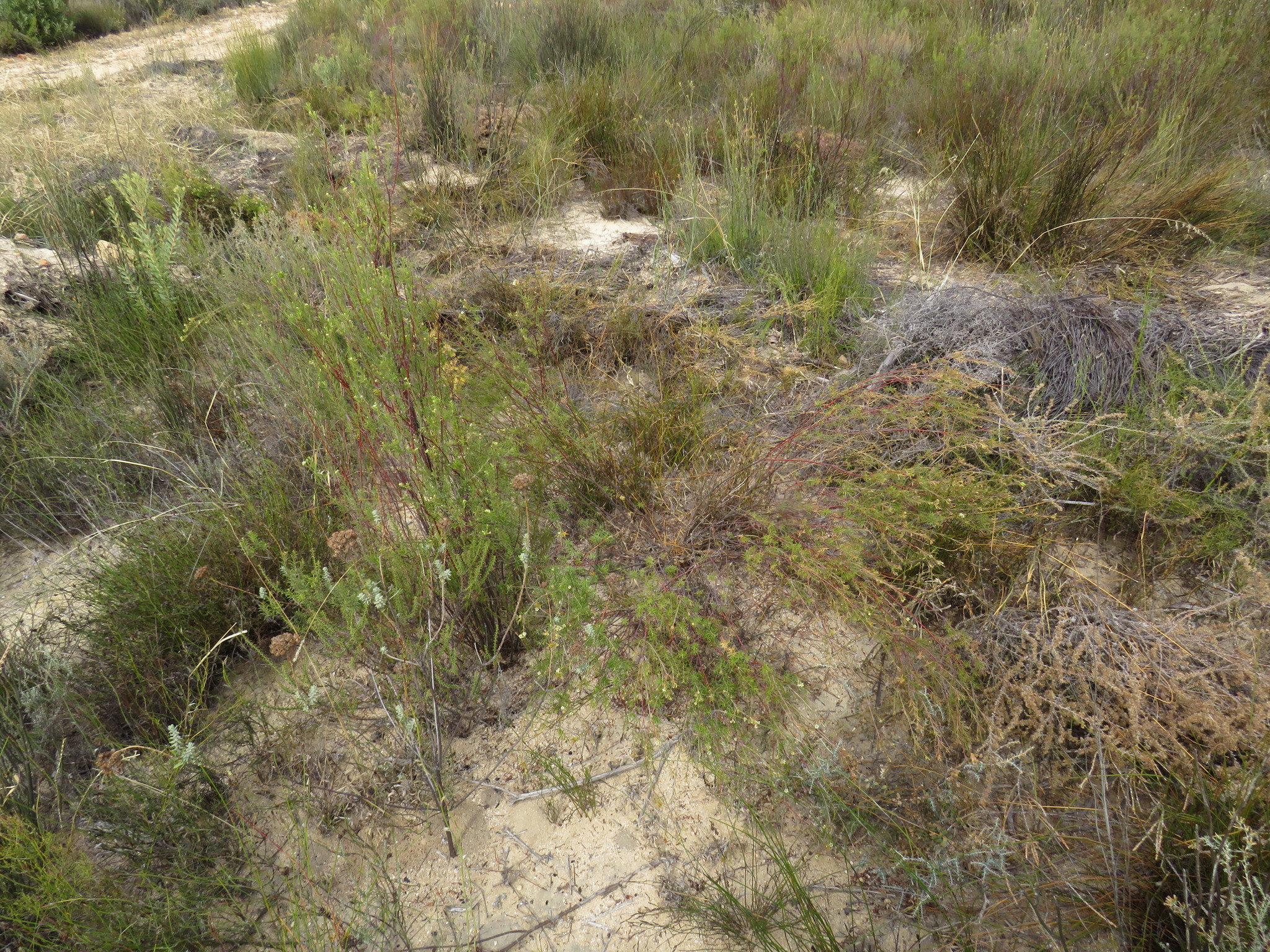
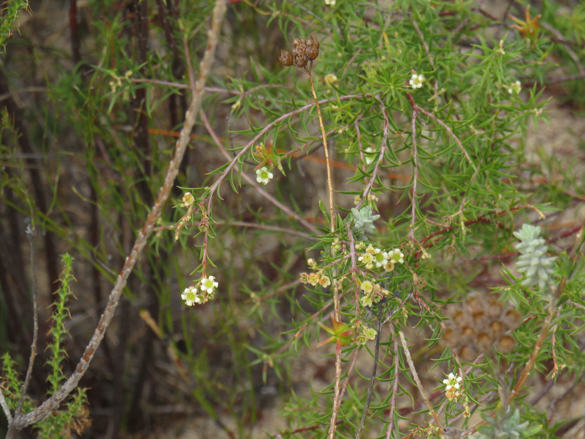
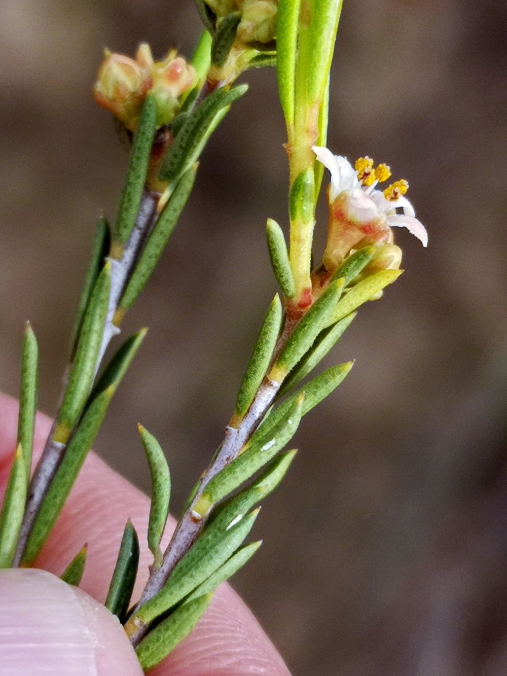
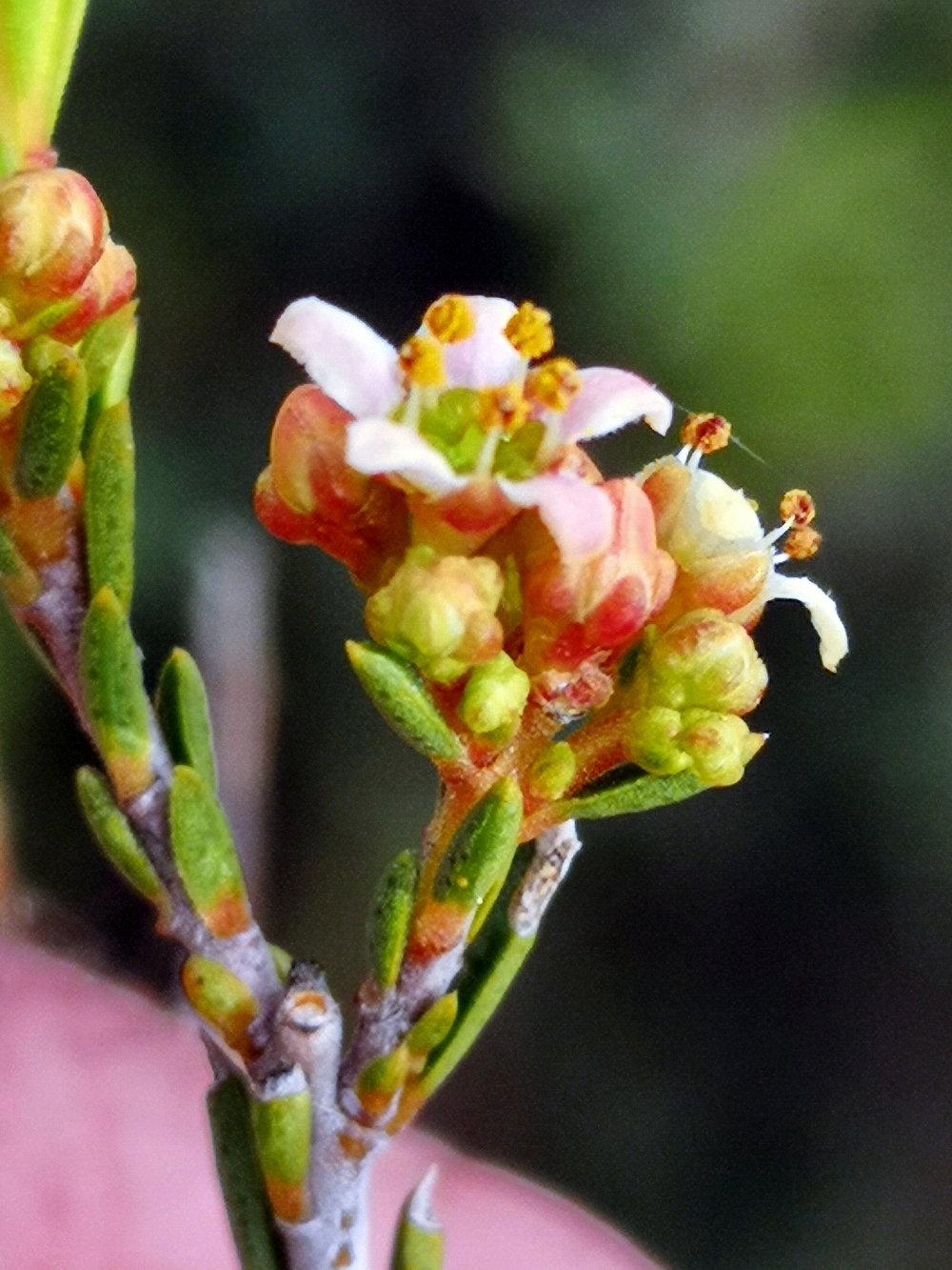
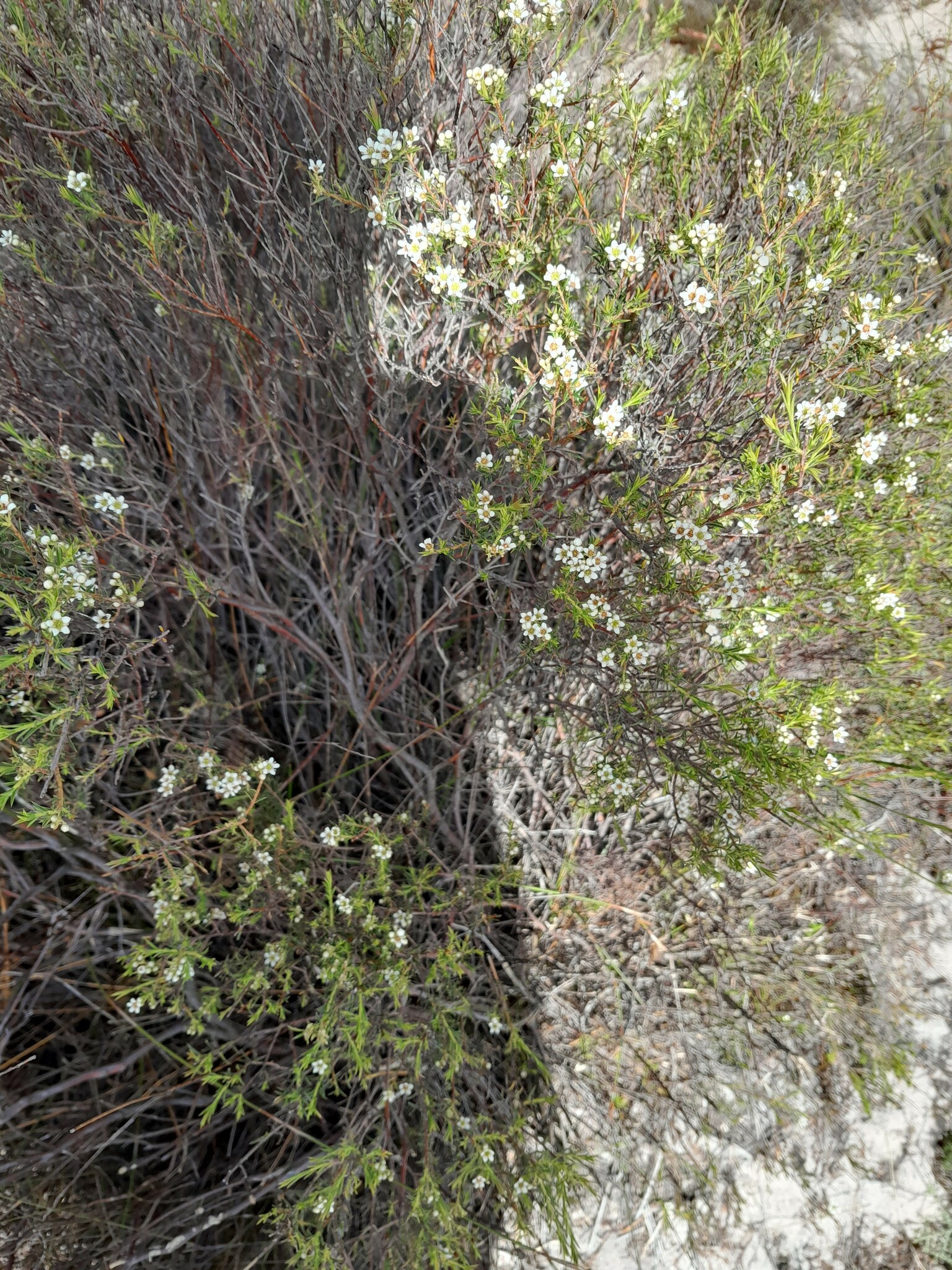
Shrubs about 1 m tall, rigid, much-branched, many-stemmed with a stout rootstock. Branches erect, rigid, glabrous, forked; bark reddish-brown becoming ashy-grey with leaf scars slightly raised, branchlets erect, slender, not very numerous, not hidden by the leaves, sub-dichotomous, soon glabrous. Leaves (including the petiole 1 mm long) 8-2.5 mm long, 0.8-1 mm broad, linear-lanceolate, acute, glabrous, alternate, erect-spreading; apex mucronate with a straight point; margins narrowly hyaline, sparsely serrulate; abaxial surface rounded with gland dots scattered to either side of the midrib; adaxial surface concave. Inflorescence terminal, solitary or pseudo-twin in slender reduced racemes; flowers 7 mm diam., opening in succession, delapsing if infertile. Bract 1-2 mm long, 0.7 mm broad, broadly lanceolate, acute, mucronate, glabrous, sparsely gland-dotted; margins minutely ciliolate. Bracteoles two, 0.8 mm long, 0.7 mm broad, ovate, minutely apiculate, sparsely gland-dotted; margins minutely ciliolate, translucent. Calyx lobes five, 1.3 mm long, 1.5 mm broad, broadly ovate, obtuse, glabrous, sparsely gland-dotted; apex thickened; margins minutely ciliolate, translucent. Petals five, 2.5-3 mm long, 1.8-2.5 mm broad, orbicular, white, glabrous, sessile, spreading, arising high up on the lobe of the disc; margins ciliate-denticulate, irregular. Staminodes none. Filaments five, becoming 1.7 mm long after anthesis, acicular, spreading, glabrous. Anthers five, before anthesis 0.9-1.1 mm long, 0.8 mm broad, yellow, apical gland sessile, inclined inwards. Pollen 51 µ long, 29 µ broad, elliptic, many malformed. Disc 5-lobed, sinuate, green, fleshy, minutely punctate, spreading, exceeding the ovary by a long way. Stigma 0.2-0.4 mm diam., capitellate, green. Style becoming 1.3-1.7 mm long, glabrous, deflexed at first. Ovary 5-carpellate, 0.7 mm diam., glabrous, lobes obtuse. Fruit 5-carpellate, 1.2 mm long overall, 0.8 mm diam., glabrous, pitted with gland dots, becoming ±2.5 mm pedicellate above the calyx when mature; horns ±5 mm long, spreading at 45°. Seed ±7 mm long, 3 mm broad, black, shining; aril for the most part black. From: Williams, I. 1979. Studies in the genera of the Diosmeae (Rutaceae): 8. J. S. African Bot. 45(2): 147-184. [CC BY]
Like D. hirsuta but plants robust, to 1 m, petals soon falling, fruits pedicellate above calyx when mature and not associated with petals. From: Manning, JC; Goldblatt, P. 2012. Rutaceae: Diosma L. In: J Manning & P Goldblatt (eds), Plants of the Greater Cape Floristic Region 1: The Core Cape flora. Strelitzia 29: 718-719. South African National Biodiversity Institute, Pretoria. [CC BY]
Diosma pedicellata is a distinct species and differs in being usually a tall stiff much-branched shrub, many-stemmed at base, having leaves petiolate with a narrow midrib when dry and the apex with a straight point; flowers 7 mm diam.; calyx glabrous; petals spreading, glabrous, narrowly sessile with margins irregular; fruit becoming pedicellate above the calyx. From: Williams, I. 1979. Studies in the genera of the Diosmeae (Rutaceae): 8. J. S. African Bot. 45(2): 147-184. [CC BY]
Most areas where D. pedicellata is found are either being invaded by introduced Acacias or being strip ploughed for agricultural purposes. From: Williams, I. 1979. Studies in the genera of the Diosmeae (Rutaceae): 8. J. S. African Bot. 45(2): 147-184. [CC BY]
Sandy and stony slopes and flats. From: Manning, JC; Goldblatt, P. 2012. Rutaceae: Diosma L. In: J Manning & P Goldblatt (eds), Plants of the Greater Cape Floristic Region 1: The Core Cape flora. Strelitzia 29: 718-719. South African National Biodiversity Institute, Pretoria. [CC BY]
The main centre of distribution of this species lies in an area to the east of the Piketberg, from Sauer in a north-westerly direction to just beyond Papkuilsfontein. From: Williams, I. 1979. Studies in the genera of the Diosmeae (Rutaceae): 8. J. S. African Bot. 45(2): 147-184. [CC BY]
Bokkeveld Mtns to False Bay. From: Manning, JC; Goldblatt, P. 2012. Rutaceae: Diosma L. In: J Manning & P Goldblatt (eds), Plants of the Greater Cape Floristic Region 1: The Core Cape flora. Strelitzia 29: 718-719. South African National Biodiversity Institute, Pretoria. [CC BY]
August
15 to 600 m
This map contains point-based occurrences at different locations
Occurrence in the Flora of Southern Africa (FSA) countries and South African provinces. Residence status indicates if a taxon is indigenous, endemic, naturalised or invasive in a specific region. This data is based on specimen records and literature
FSA
SA
BOT
NAM
ESW
LES
WC
EC
NC
FS
GA
KZN
LP
MP
NW
Absent
Indigenous
Endemic
Naturalised
Invasive
Names and Sources
| Common name | Language | Reference/barcode | Published as |
|---|---|---|---|
| Naeltjiesbos | Afrikaans | PRE0567640-0 |
Classification
KINGDOM Plantae
SUBKINGDOM Phanerogamae
PHYLUM Anthophyta
ORDER Sapindales
FAMILY Rutaceae
SUBFAMILY Aurantioideae
TRIBE Clauseneae
GENUS Diosma
SPECIES pedicellata
56 results for Diosma pedicellata I.Williams
Year
Barcode: NBG0191554-0 Collector(s) & number: Helme, NA, 2412 | 2002-2-12
South Africa, Western Cape, Malmesbury. 7km east of Atlantis, west of N7 on Zouterivier 22, 1km NW of Rondeberg farmhouse.
Data Resource: BODATSA View record
Barcode: NBG1517517-0 Collector(s) & number: Compton, RH, 15097 | 1943-10-1
South Africa, Western Cape, Sauer. Piquetberg C.P.
Data Resource: BODATSA View record
Barcode: NBG1517383-0 Collector(s) & number: Steyn, M, 549 | 1949-9-10
South Africa, Western Cape, Near Sauer. Piquetberg, C.P.
Data Resource: BODATSA View record
Barcode: PRE0669723-0 Collector(s) & number: Linger, MT, 23 | 1982-8-10
South Africa, Western Cape, Plettenberg Bay.; Robberg Nat. Res.; The Ledge. N. slope of Robberg overlooking the ledge.
Data Resource: BODATSA View record
Barcode: NBG1517514-0 Collector(s) & number: Cloete, I, 17 | 1987-7-6
South Africa, Western Cape, Ceres Valley. Wolvenhuis 371. Schoonvlei Industrial Area 4 km outside Ceres. 19°19' S; 33°20'20" E
Data Resource: BODATSA View record
Barcode: NBG1517524-0 Collector(s) & number: Winkler, DJ, 111 | 1956-7-24
South Africa, Western Cape, Darling Flora Reserve. Malmesbury, C.P.
Data Resource: BODATSA View record
Barcode: PRE0006544-0 Collector(s) & number: Williams, IJM, 2328 | 1977-8-11
South Africa, Western Cape, Piquetberg District: 4 miles NW of Papkuilfontein near Aurora.
Data Resource: BODATSA View record
Barcode: PRE0601605-0 Collector(s) & number: Williams, IJM, 3101 | 1980-11-25
South Africa, Western Cape, WORCESTER DIV.; SKERPENHEUWEL.; TAFELKOPPIE OF THE BREEDE RIVER.
Data Resource: BODATSA View record
Barcode: NBG1517387-0 Collector(s) & number: Negin, ML, 26 | 1971-7-27
South Africa, Western Cape, Kalabas Kraal.
Data Resource: BODATSA View record
Barcode: NBG1517515-0 Collector(s) & number: Compton, RH, 19887 | 1947-8-23
South Africa, Western Cape, Darling. Malmesbury C.P.
Data Resource: BODATSA View record
Barcode: PRE0541216-0 Collector(s) & number: Williams, IJM, 2638 | 1978-11-7
South Africa, Western Cape, RIEBEEKKASTEEL; 1 KM. E OF RAILWAY CROSSING
Data Resource: BODATSA View record
Barcode: NBG1517513-0 Collector(s) & number: Hugo, L, 2492 | 1981-3-9
South Africa, Western Cape, Witzenberg Pass.
Data Resource: BODATSA View record
Barcode: NBG1517518-0 Collector(s) & number: Compton, RH, 10377 | 1941-1-18
South Africa, Western Cape, Bottelary
Data Resource: BODATSA View record
Barcode: PRE0006515-0 Collector(s) & number: Williams, IJM, 2393 | 1977-11-16
South Africa, Western Cape, Piquetberg District: 4 miles South of Papkuilsfontein near Aurora.
Data Resource: BODATSA View record
Barcode: NBG1517512-0 Collector(s) & number: Boucher, C, 3182 | 1976-9-5
South Africa, Western Cape, Vensterklip to south of Verlorenvlei. Sandstone Mountain.
Data Resource: BODATSA View record
Barcode: PRE0567640-0 Collector(s) & number: Hanekom, WJ, 3290 | 2000-3-22
South Africa, Western Cape, Citrusdal. Top end of Theerivier. The Kelderdeur in Haarwegskloof.
Data Resource: BODATSA View record
Barcode: PRE0009793-0 Collector(s) & number: Bean, PA, 2593 | 1990-9-20
South Africa, Western Cape, Montagu District: Waboomberg; Rooihoogte Pass on the hairpin bend.
Data Resource: BODATSA View record
Barcode: NBG0197220-0 Collector(s) & number: Julies, R, 12 | 2003-10-30
South Africa, Western Cape, Limietberg Nature Reserve. Agter Tafelberg.
Data Resource: BODATSA View record
Barcode: NBG1517516-0 Collector(s) & number: Williams, I, 2409 | 1977-12-6
South Africa, Western Cape, Tiny Versveld Nature Reserve near Darling, Malmesbury Div.
Data Resource: BODATSA View record
Barcode: NBG0170752-0 Collector(s) & number: Hanekom, WJ, 3196 | 1999-10-7
South Africa, Western Cape, Citrusdal. Paardekop. Dry fountain south of Oom Willem's homestead.
Data Resource: BODATSA View record
Barcode: PRE0607021-0 Collector(s) & number: Goldblatt, P, 5315 | 1979-11-10
South Africa, Western Cape, CAPE TOWN; MALMESBURY; 5 KM S MALMESBURY
Data Resource: BODATSA View record
Barcode: NBG1517389-0 Collector(s) & number: Williams, I, 1858 | 1973-8-28
South Africa, Western Cape, 1.6 km from Faure, at Raphaels, on old Nat. Rd.
Data Resource: BODATSA View record
Barcode: NBG1517519-0 Collector(s) & number: Williams, I, 1920 | 1974-11-7
South Africa, Western Cape, Just beyond the waterfall river bridge on the road from Citrusdal to the Cold Bokkeveld near Allandale.
Data Resource: BODATSA View record
Barcode: NBG0247956-0 Collector(s) & number: Boucher, C, 7517 | 2008-2-8
South Africa, Western Cape, Cape Flats. Faure. Vergenoegd Farm Extension Portion 653-15. Flats along east side of north-western farm entrance road. Community E. 34° 01.869'S, 18° 43.873'E.
Data Resource: BODATSA View record
Barcode: PRE0568898-0 Collector(s) & number: Meyer, JJ, 2467 | 1999-11-1
South Africa, Western Cape, Citrusdal District. Middelberg Pass on Kleinplaas Farm. At farm gate.
Data Resource: BODATSA View record
Barcode: NBG1517523-0 Collector(s) & number: Taylor, HC, 7.1 | 1997-9-9
South Africa, Western Cape, N7 roadside survey, Citrusdal-Algeria turnoff
Data Resource: BODATSA View record
Barcode: NBG0212201-0 Collector(s) & number: Von Witt, C, CR1707 | 2007-9-27
South Africa, Western Cape, Malmesbury. Abbotsvale. DDS= 32.99874 ; DDE= 17.93080 .
Data Resource: BODATSA View record
Barcode: NBG1472382-0 Collector(s) & number: Helme, NA, 8444 | 2015-2-9
South Africa, Western Cape, 10 km SE of Aurora; Stinkfontein A97.
Data Resource: BODATSA View record
Barcode: NBG1483984-0 Collector(s) & number: Esterhuizen, N, 47 | 2017-8-21
South Africa, Western Cape, On the farm Kersefontein, approximately 20 km south-east of the town Velddrif in the Western Cape province of South Africa.
Data Resource: BODATSA View record
Barcode: NBG0114778-0 Collector(s) & number: Williams, IJM, 2328 | 1977-8-11
South Africa, Western Cape, Clanwilliam. Piquetberg Div., 4 m northwest of Papkuilsfontein near Aurora.
Data Resource: BODATSA View record
Barcode: NBG1548096-0 Collector(s) & number: Helme, NA, 9645 | 2019-9-16
South Africa, Western Cape, Voetpad farm, north base of Piketberg.
Data Resource: BODATSA View record
Barcode: NBG1517386-0 Collector(s) & number: Williams, I, 2104 | 1975-10-9
South Africa, Western Cape, Tulbagh Waterfall.
Data Resource: BODATSA View record
Barcode: NBG1517381-0 Collector(s) & number: Williams, I, 3101 | 1980-11-25
South Africa, Western Cape, Tafelkoppie, Skerpenheuwel, south of Breede River, Worcester Division.
Data Resource: BODATSA View record
Barcode: PRE0554011-0 Collector(s) & number: Boucher, C, 3588 | 1978-2-7
South Africa, Western Cape, KERSEFONTEIN; ZOUTEKLOOF; 5 KM. E. OF KERSEFONTEIN
Data Resource: BODATSA View record
Barcode: NBG0195932-0 Collector(s) & number: Helme, NA, 2681 | 2003-6-10
South Africa, Western Cape, Worcester. Slanghoek valley below "The Cossacks", on Farm Klein Geluk 603.
General notes: Fynbos biome. Alluvial terrace fynbos vegetation. Valley. Well-drained, seasonally waterlogged, stony, sandy soil. Sandstone. Full sun. No slope. NE aspect. No biotic effect seen. Shrub. Petals white-pink. Laxly branched. Fruit absent. Plant height: 1.2 m. Uncommon. Threatened by agriculture and aliens. Growing seasonally wet sands over alluvial pebble terrace.
Data Resource: BODATSA View record
Barcode: NBG0170741-0 Collector(s) & number: Hanekom, WJ, 3253 | 1999-11-4
South Africa, Western Cape, Citrusdal. Swartberg. Looprivier. The braai place in the red grass vlei on the mountain.
Data Resource: BODATSA View record
Barcode: PRE0567641-0 Collector(s) & number: Hanekom, WJ, 3253 | 1999-11-4
South Africa, Western Cape, Citrusdal. Swartberg. Looprivier. The braai place in the red grass vlei on the mountain.
Data Resource: BODATSA View record
Barcode: PRE0526250-0 Collector(s) & number: Boucher, C, 3182 | 1976-9-5
South Africa, Western Cape, VERLOREVLEI; VENSTERKLIP; S. OF VERLOREVLEI
Data Resource: BODATSA View record
Barcode: NBG0202051-0 Collector(s) & number: Helme, NA, 3502 | 2005-7-23
South Africa, Western Cape, Vredendal. Heerenlogementsberg, SE slopes above Grootvlei.
Data Resource: BODATSA View record
Barcode: NBG0170740-0 Collector(s) & number: Hanekom, WJ, 3290 | 2000-3-22
South Africa, Western Cape, Citrusdal. Top end of Theerivier. The Kelderdeur in Haarwegskloof.
Data Resource: BODATSA View record
Barcode: NBG1517385-0 Collector(s) & number: Williams, I, 2393 | 1977-11-16
South Africa, Western Cape, 4 m north of Papkuilsfontein near Aurora, Piketberg Div.
Data Resource: BODATSA View record
Barcode: PRE0568916-0 Collector(s) & number: Meyer, JJ, 2470 | 1999-11-1
South Africa, Western Cape, Citrusdal District. Middelberg Pass on Kleinplaas Farm on border fence of Elandskloof Farm.
Data Resource: BODATSA View record
Barcode: NBG0232258-0 Collector(s) & number: Helme, NA, 5644 | 2008-8-27
South Africa, Western Cape, 6 km SE of Hopefield, Coeratenburg 307, just south of powerlines. 33°06'50.1"S: 18°21'09.4"E. Altitude: 55 m.
Data Resource: BODATSA View record
Barcode: PRE0634220-0 Collector(s) & number: Hugo, L, 2492 | 1981-3-9
South Africa, Western Cape, WITZENBERG PASS
Data Resource: BODATSA View record
Barcode: NBG0248003-0 Collector(s) & number: Cowell, C, MSBP 3659 | 2008-2-29
South Africa, Western Cape, Wolseley, housing suburb. Disa road, open patch at end of road. 33° 24' 35.4"S, 19° 12' 29.0"E.
Data Resource: BODATSA View record
Barcode: PRE0568897-0 Collector(s) & number: Meyer, JJ, 2472 | 1999-11-1
South Africa, Western Cape, Citrusdal District. Middelberg Pass on Kleinplaas Farm on border fence of Elandskloof Farm.
Data Resource: BODATSA View record
Barcode: NBG1517520-0 Collector(s) & number: Taylor, LE, 2891 | 1947-10-2
South Africa, Western Cape, Top of Van Rhyns's Pass C.P.
Data Resource: BODATSA View record
Barcode: NBG1517521-0 Collector(s) & number: Williams, I, 2638 | 1978-11-7
South Africa, Western Cape, 1 km east of Riebeekkasteel railway crossing.
Data Resource: BODATSA View record
Barcode: NBG1517382-0 Collector(s) & number: Williams, I, 2394 | 1977-11-16
South Africa, Western Cape, 1 m south of turn-in to Aurora, Piketberg Div.
Data Resource: BODATSA View record
Barcode: NBG1517522-0 Collector(s) & number: Compton, RH, 14987 | 1943-9-28
South Africa, Western Cape, Malmesbury C.P.
Data Resource: BODATSA View record
Barcode: NBG1517384-0 Collector(s) & number: Goldblatt, P, 5315 | 1979-11-10
South Africa, Western Cape, Cape Town; 5 km S Malmesburg.
Data Resource: BODATSA View record
Barcode: WAG.1255788 | Collector(s) & number: Goldblatt P , Goldblatt, P 5315 | 1979-11-10
South Africa
Data Resource: https://ror.org/0566bfb96 View record
Barcode: WAG.1255789 | Collector(s) & number: Goldblatt P , Goldblatt, P 3966 | 1976-08-26
South Africa
Data Resource: https://ror.org/0566bfb96 View record
This map contains point-based occurrences at different locations
2012
SERIES CHAPTER
Rutaceae: Diosma L. Manning, JC; Goldblatt, PIn: J Manning & P Goldblatt (eds), Plants of the Greater Cape Floristic Region 1: The Core Cape flora. Strelitzia 29: 718-719
South African National Biodiversity Institute, Pretoria
1979
PERIODICAL/JOURNAL
Studies in the genera of the Diosmeae (Rutaceae): 8 Williams, IJournal of South African Botany 45(2)147-184
No results found for Diosma pedicellata I.Williams
Status and criteria
NT
Assessor(s)
Plantae Coordinator
| Part(s) of plant used | Use(s) | Reference |
|---|
Coming soon...
