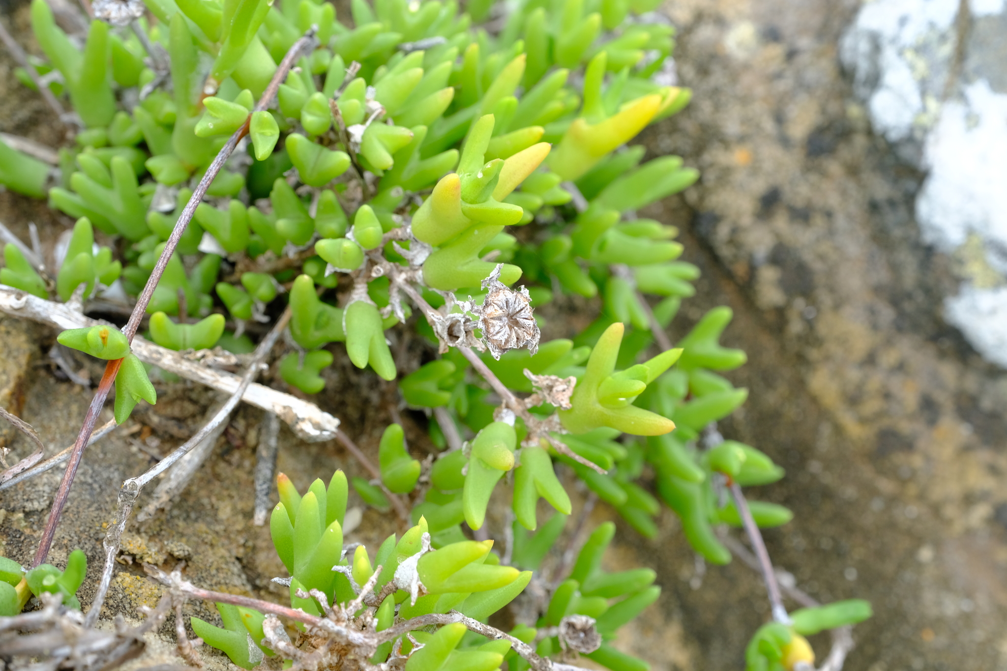
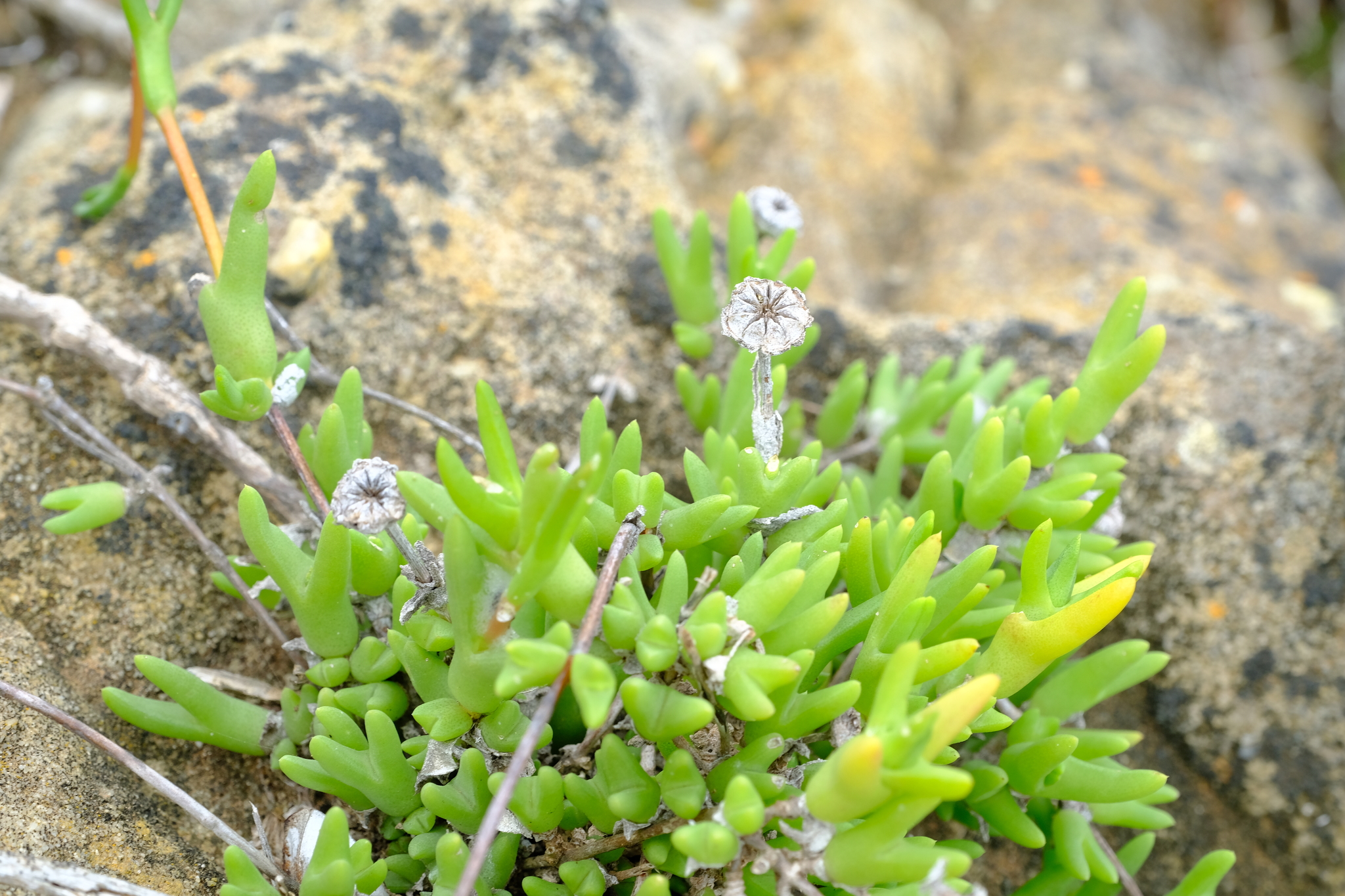
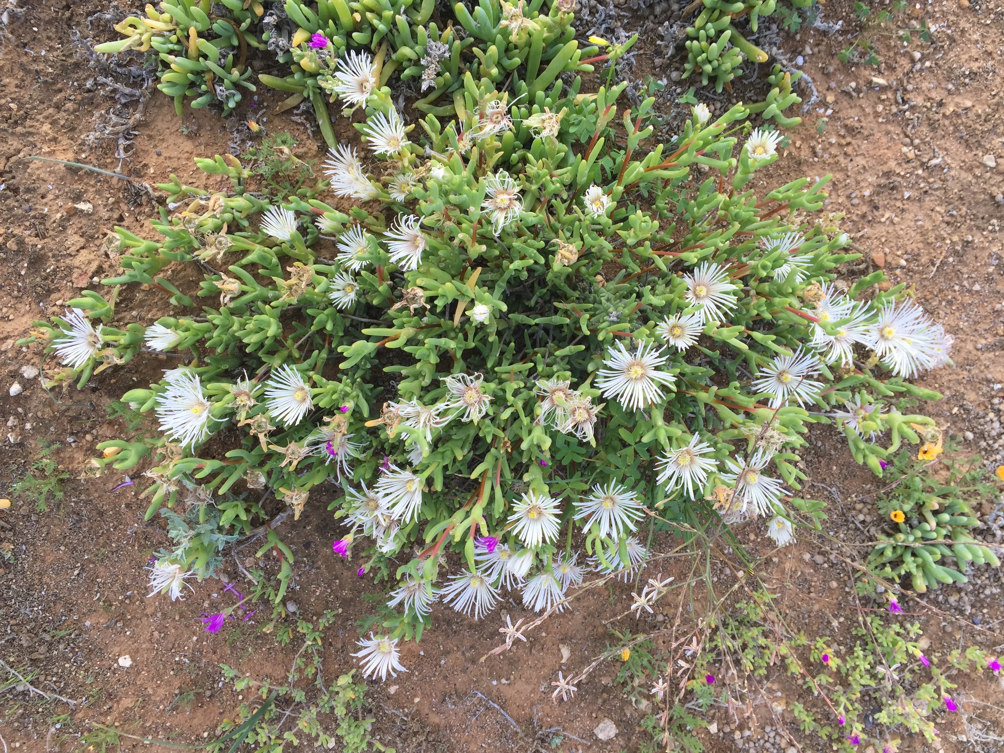
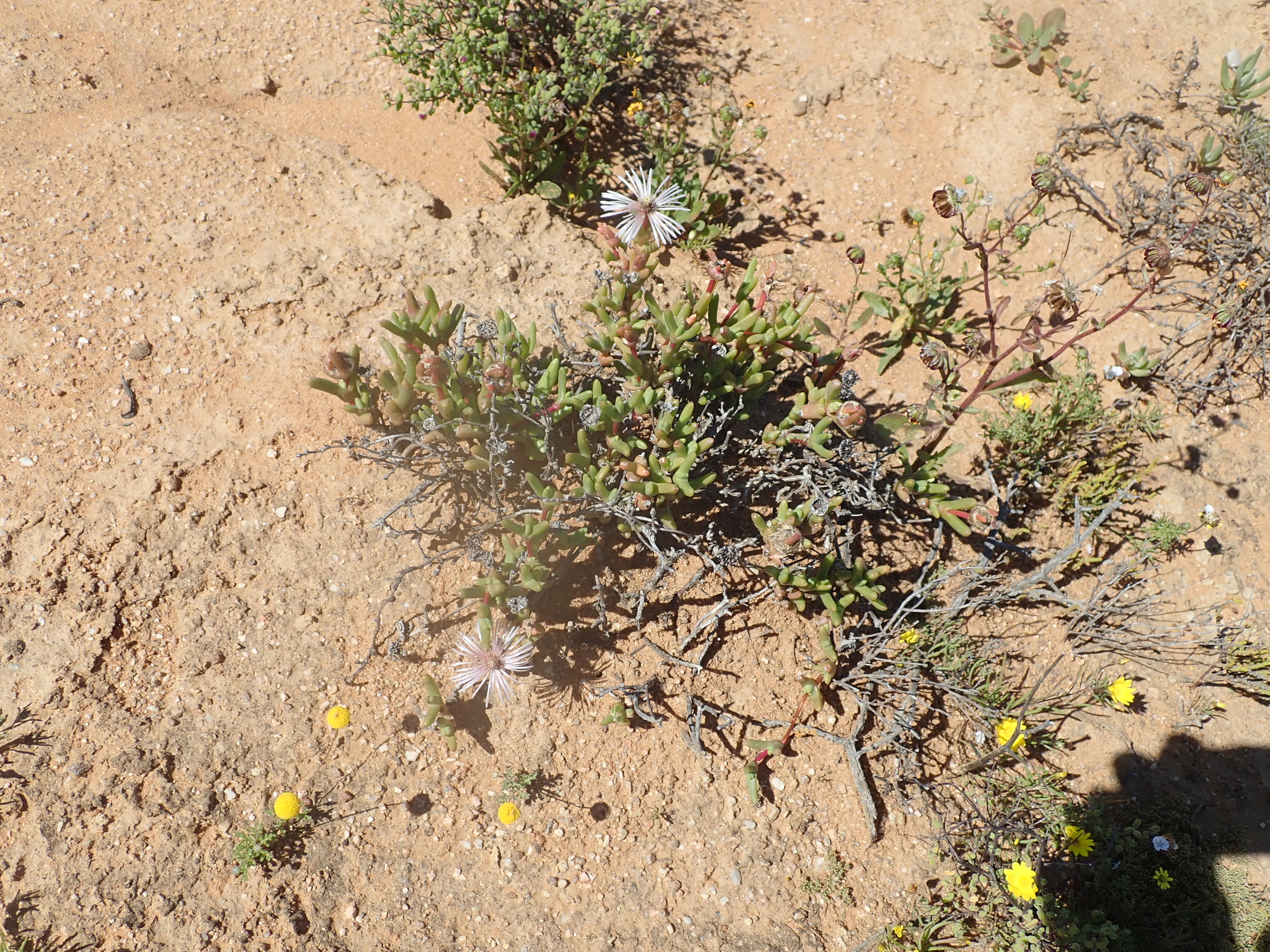
PLANTAE / PHANEROGAMAE / ANTHOPHYTA / CARYOPHYLLALES / AIZOACEAE / RUSCHIOIDEAE / RUSCHIEAE / VANZIJLIA / ANNULATA

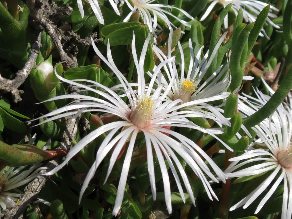
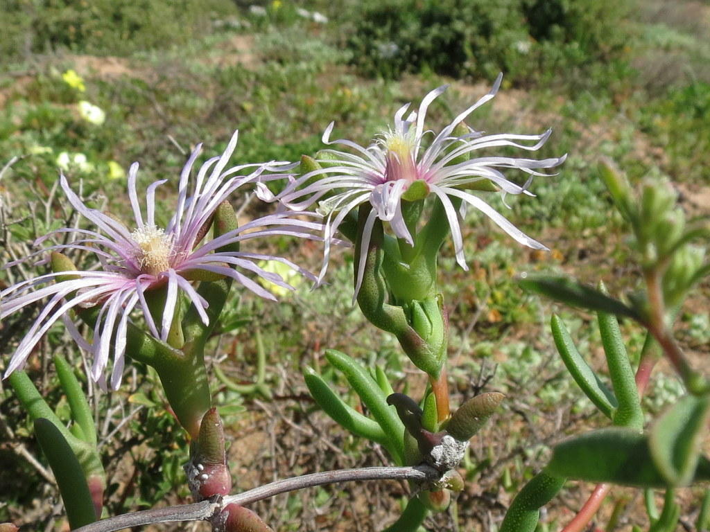
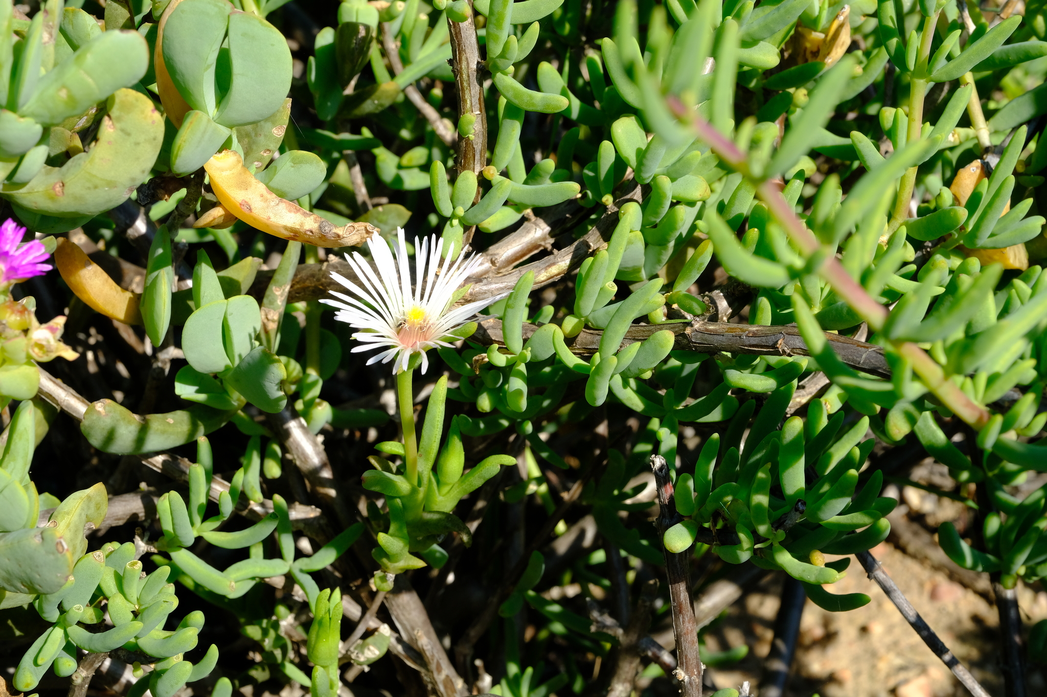
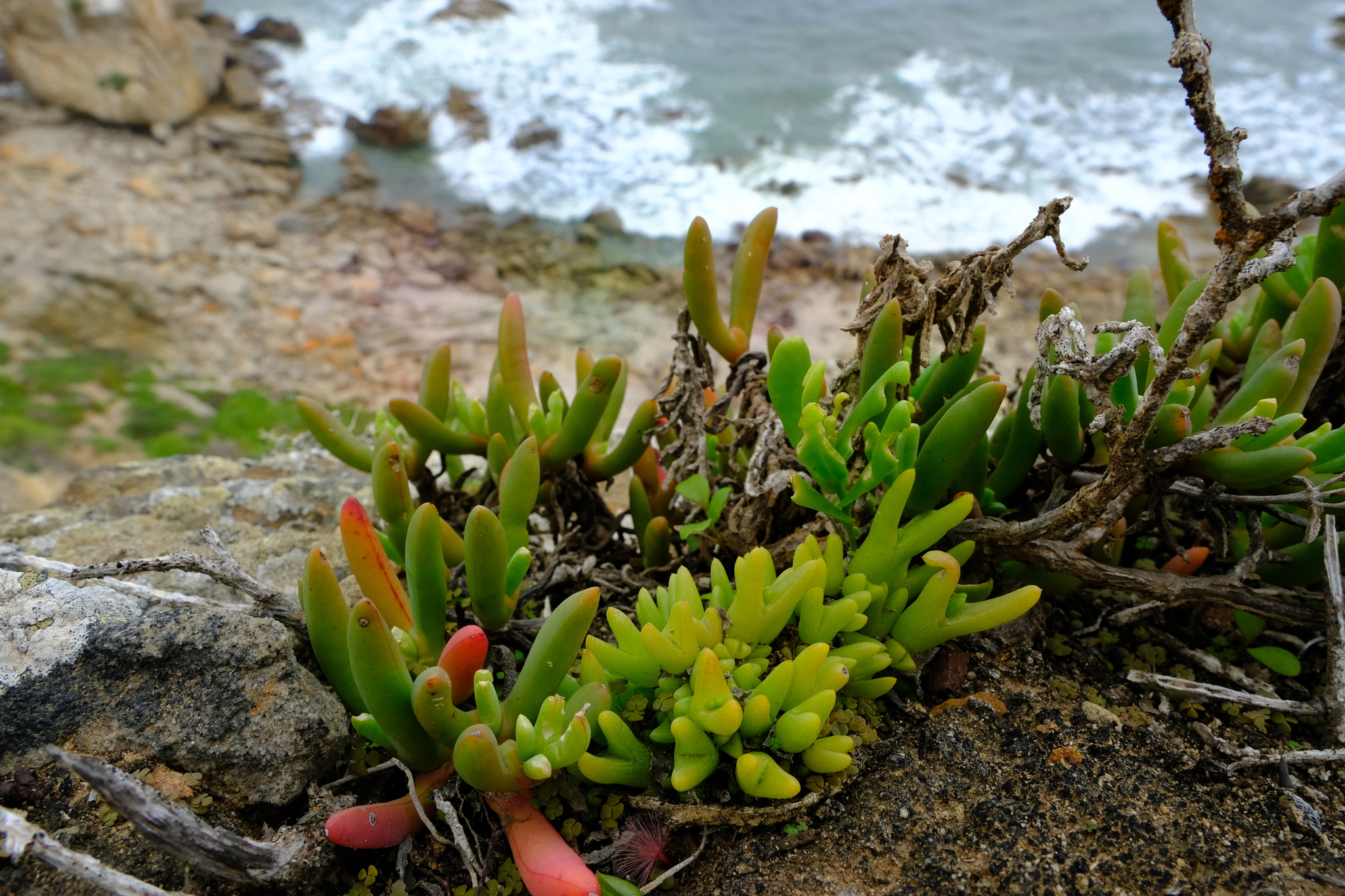
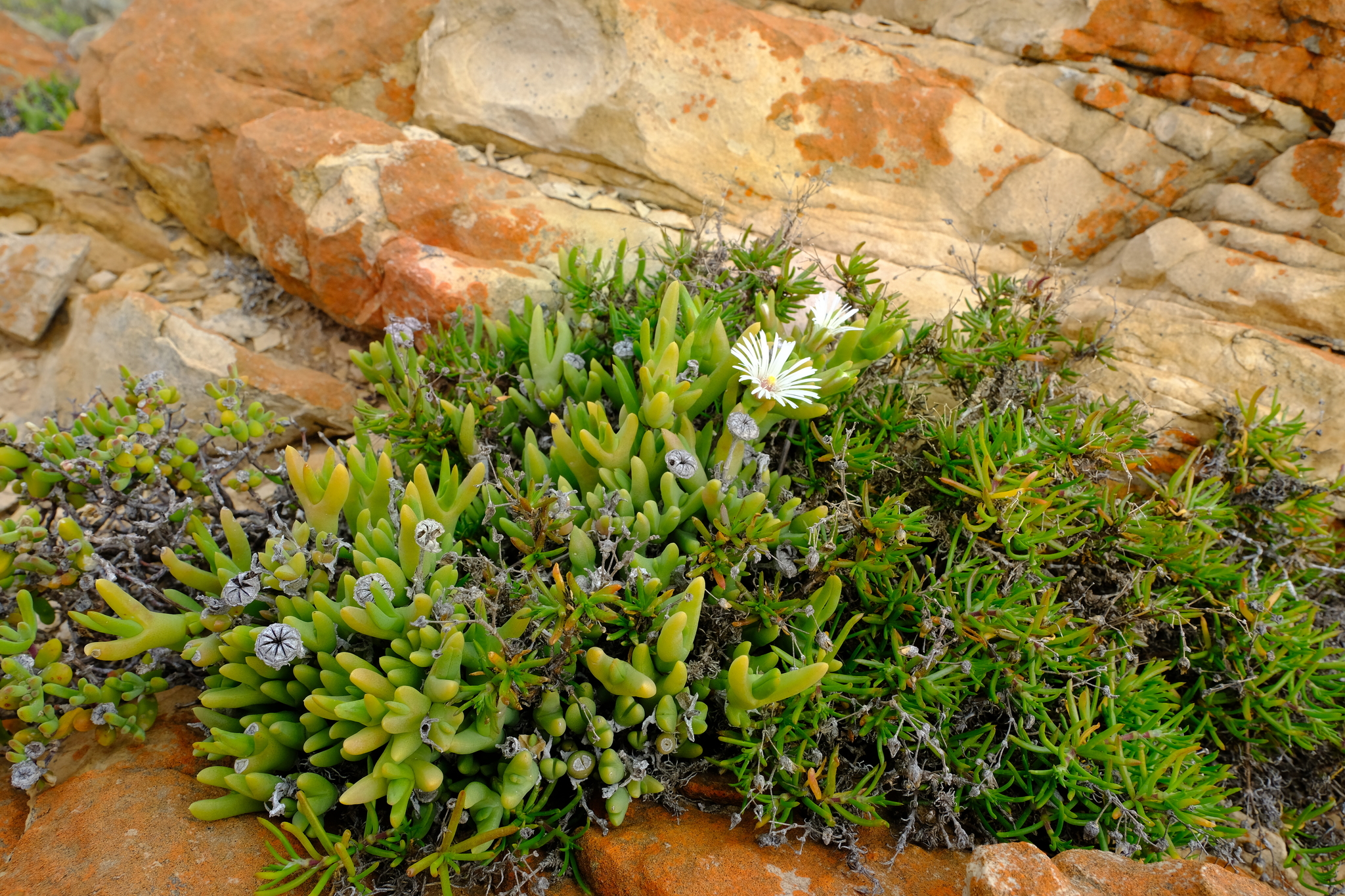
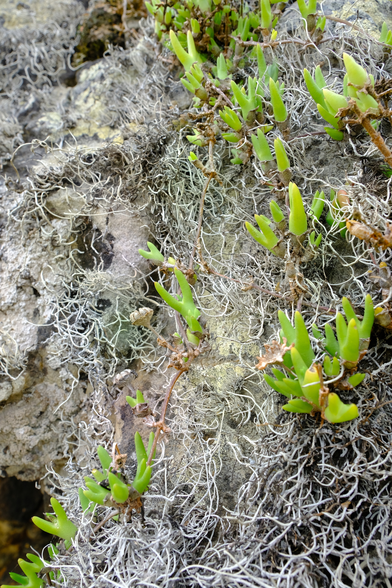
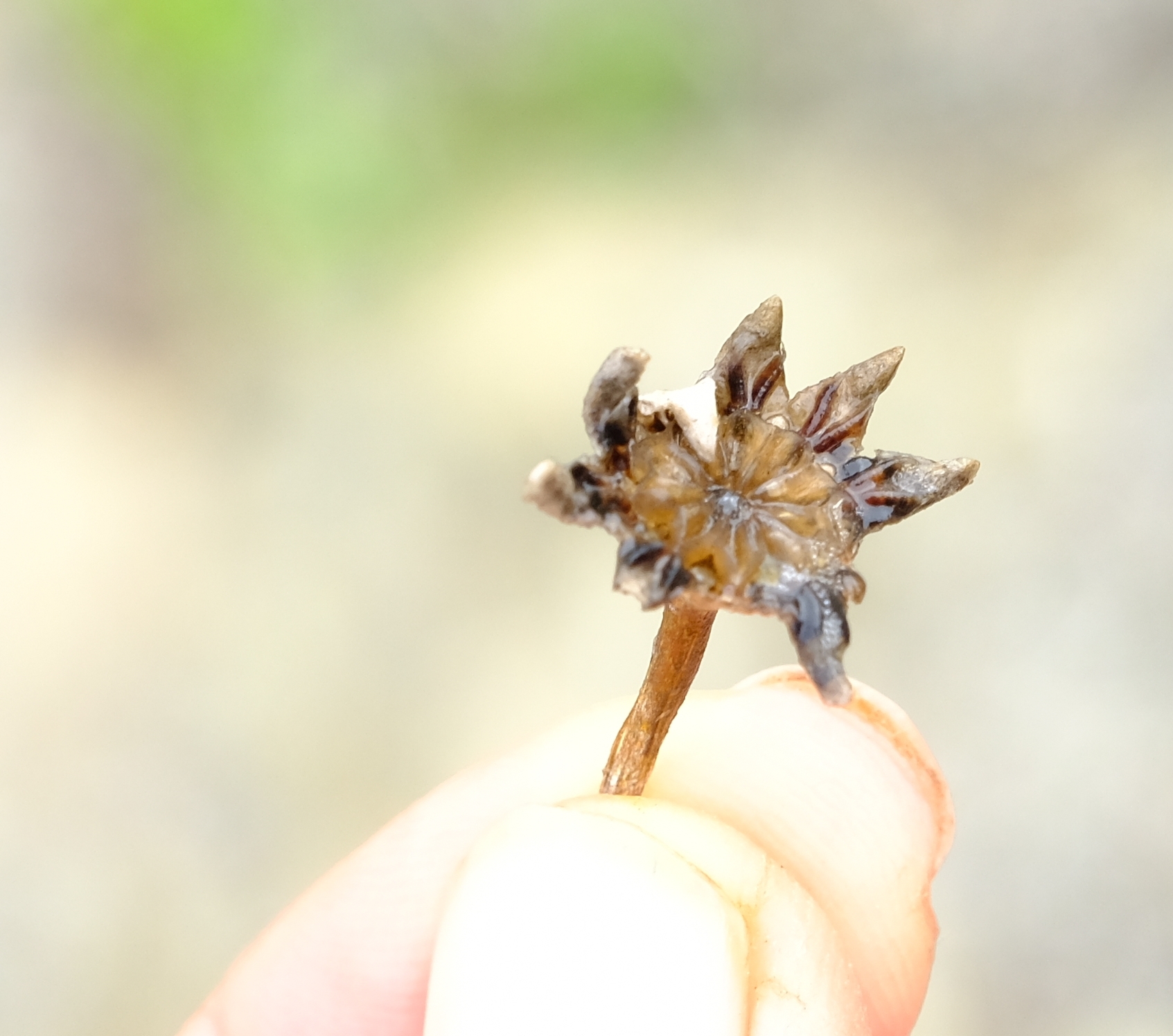
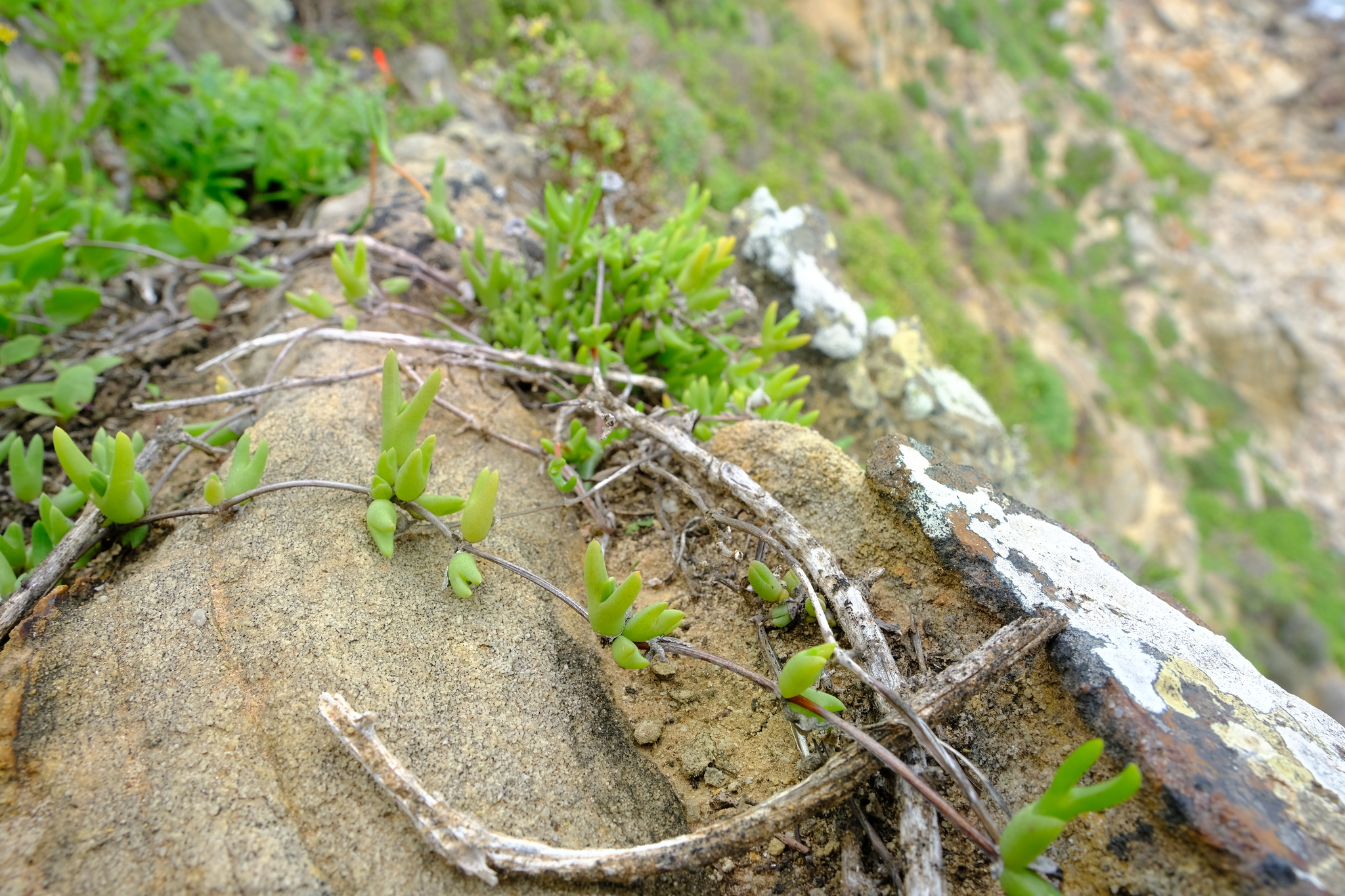
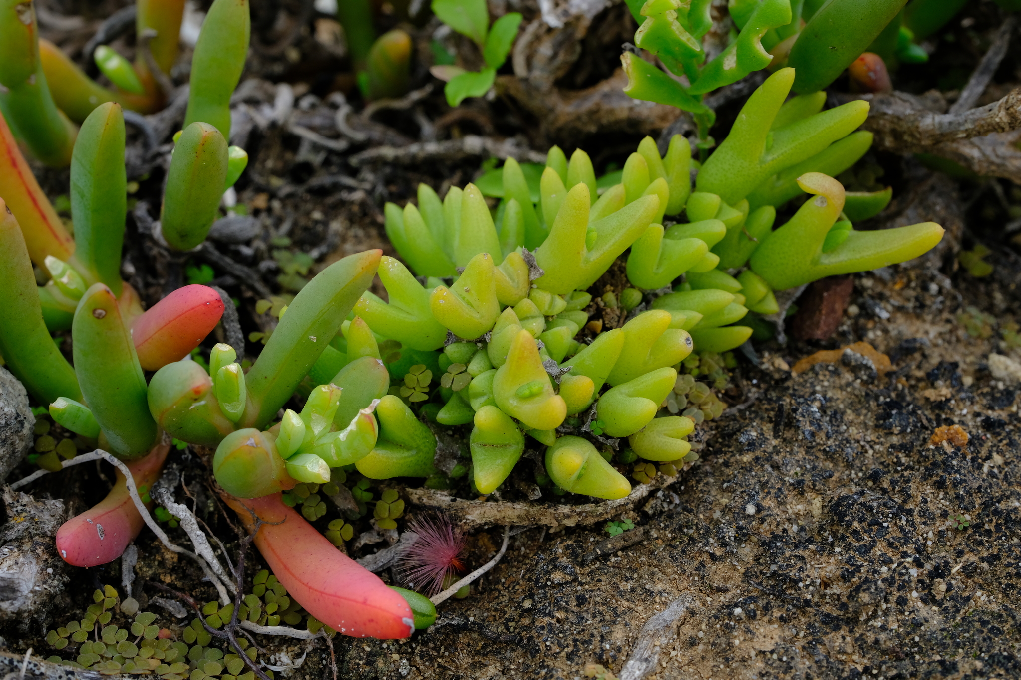
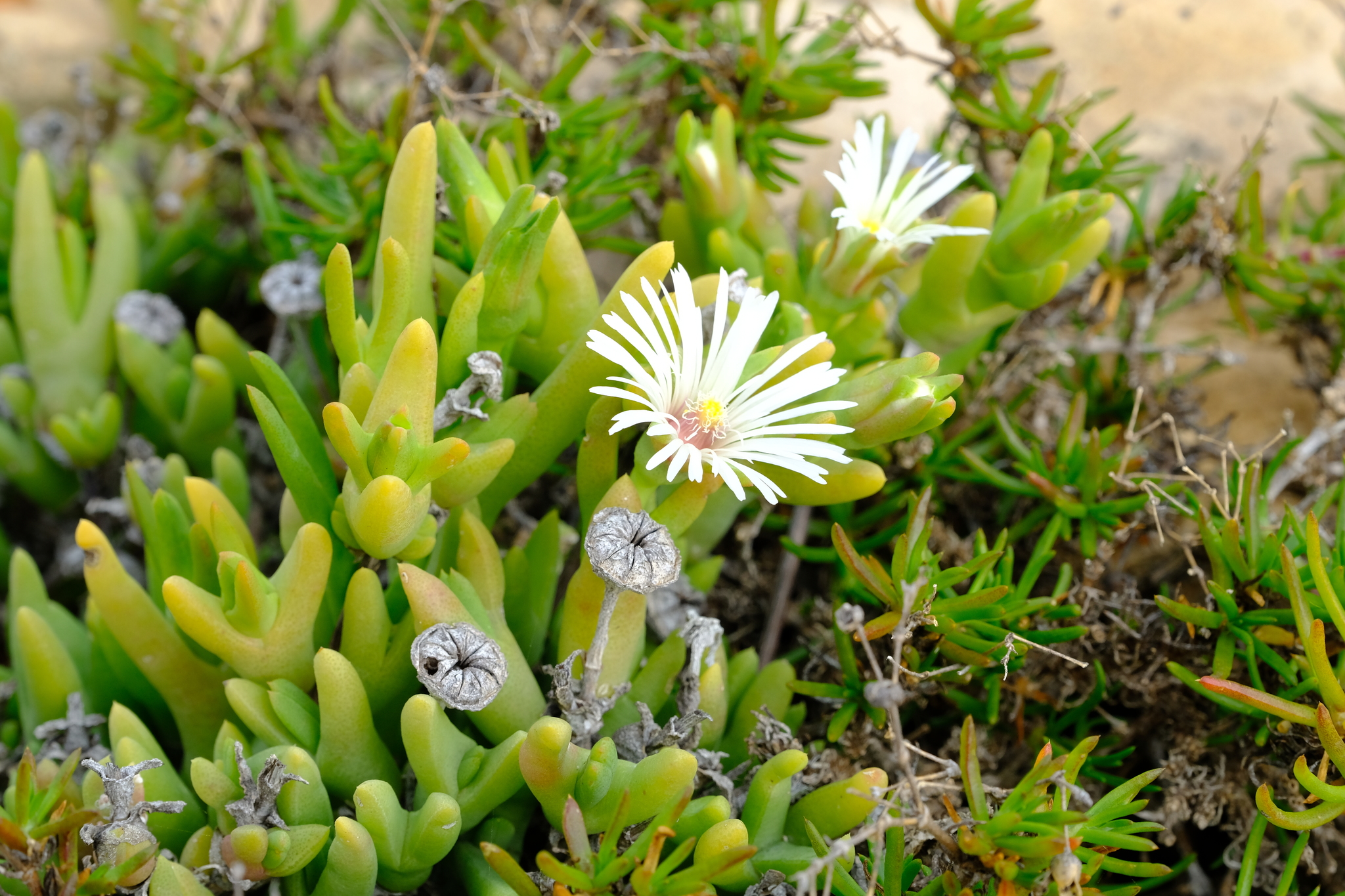
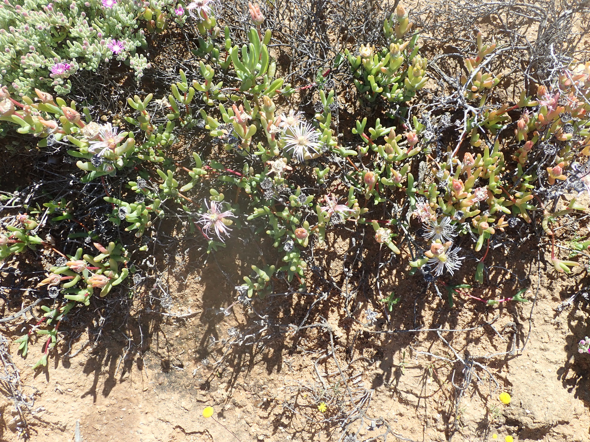
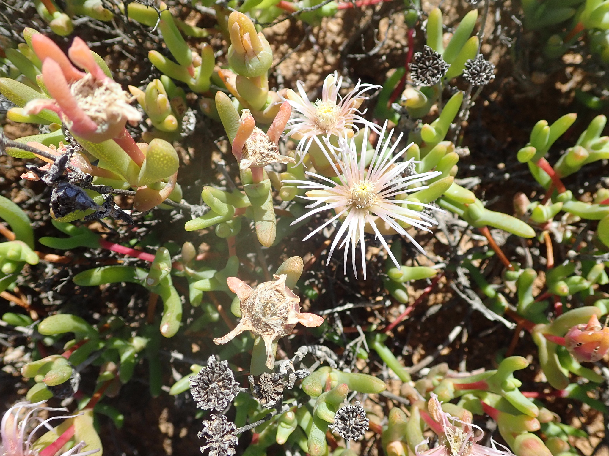
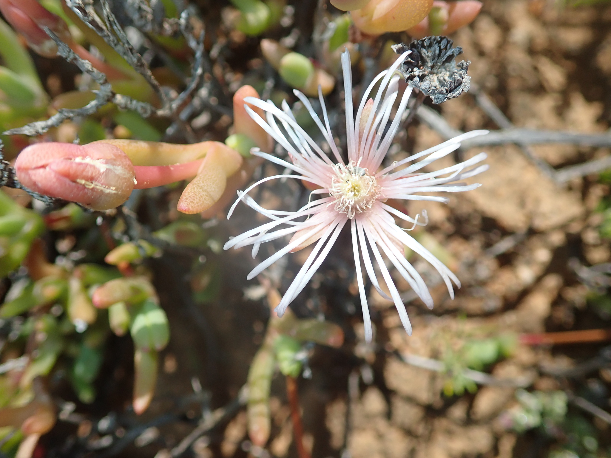
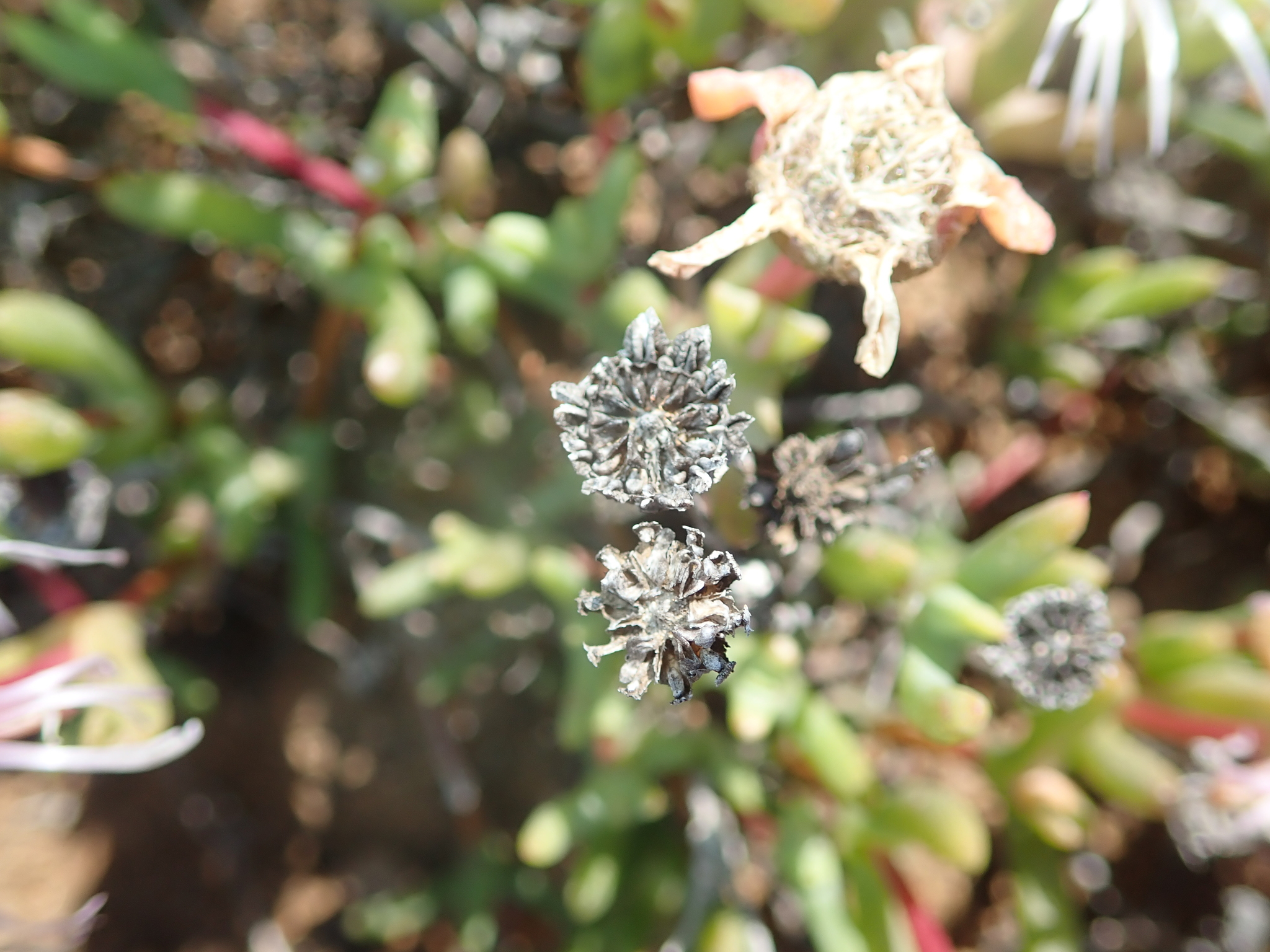
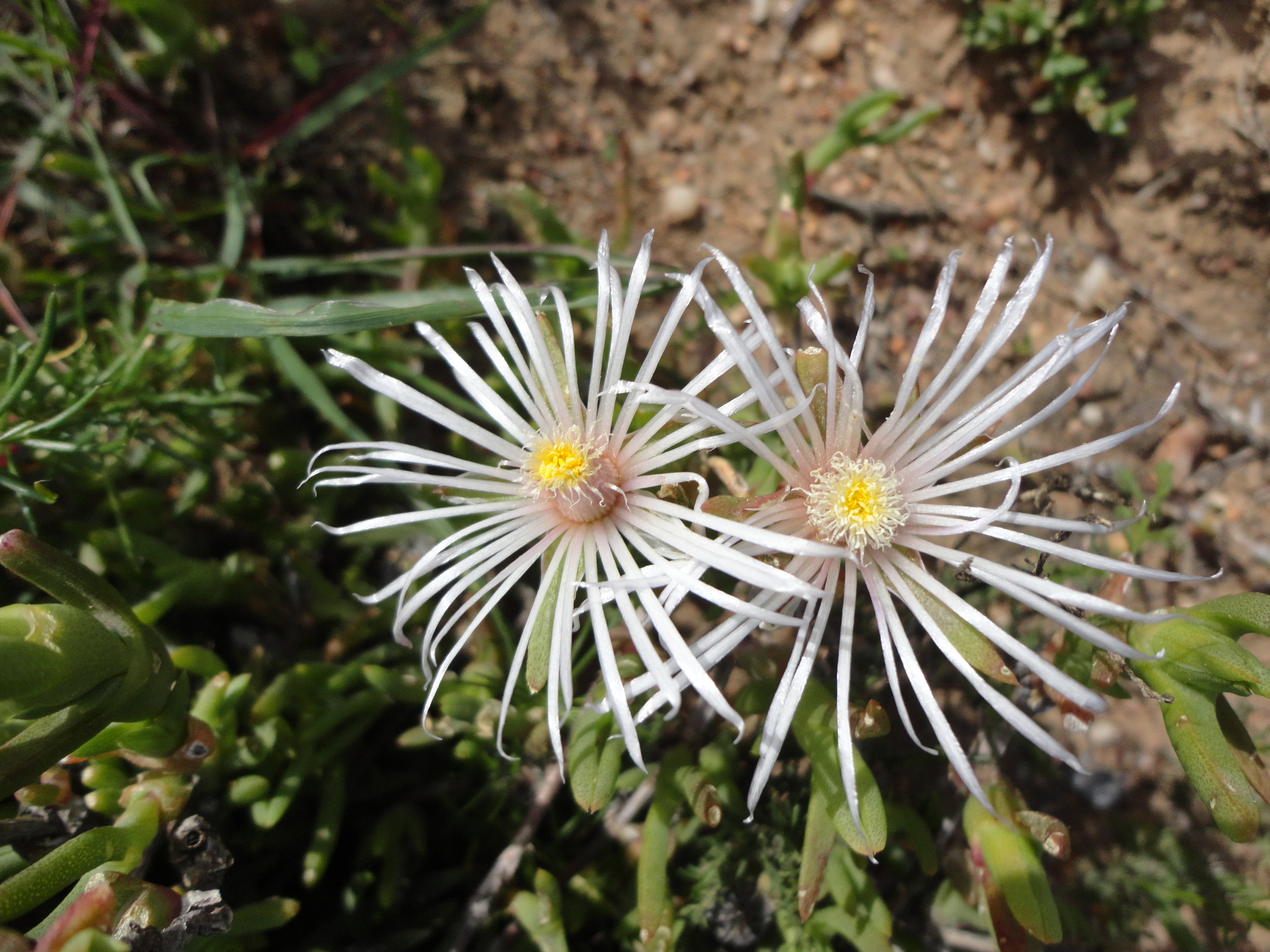
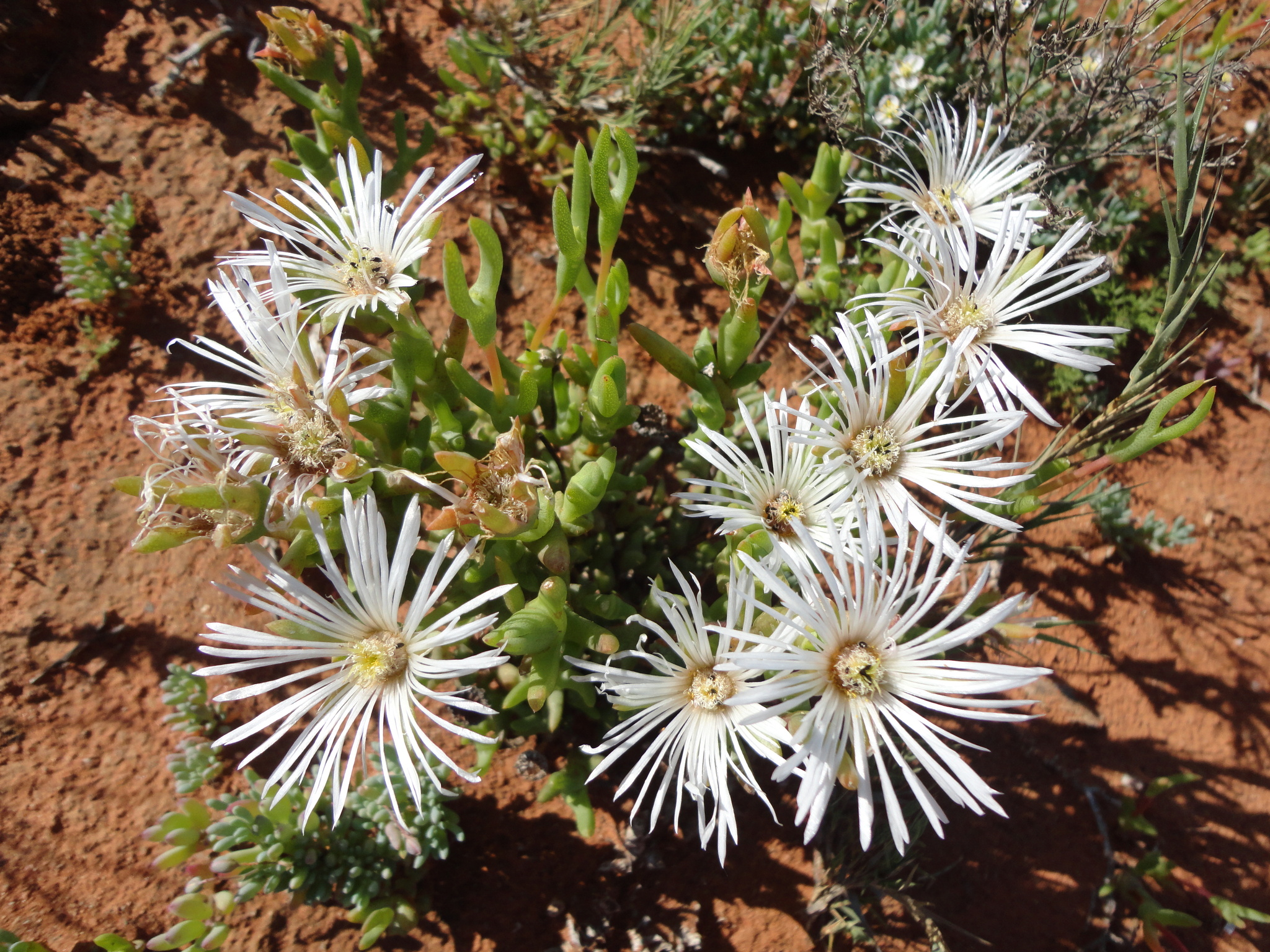
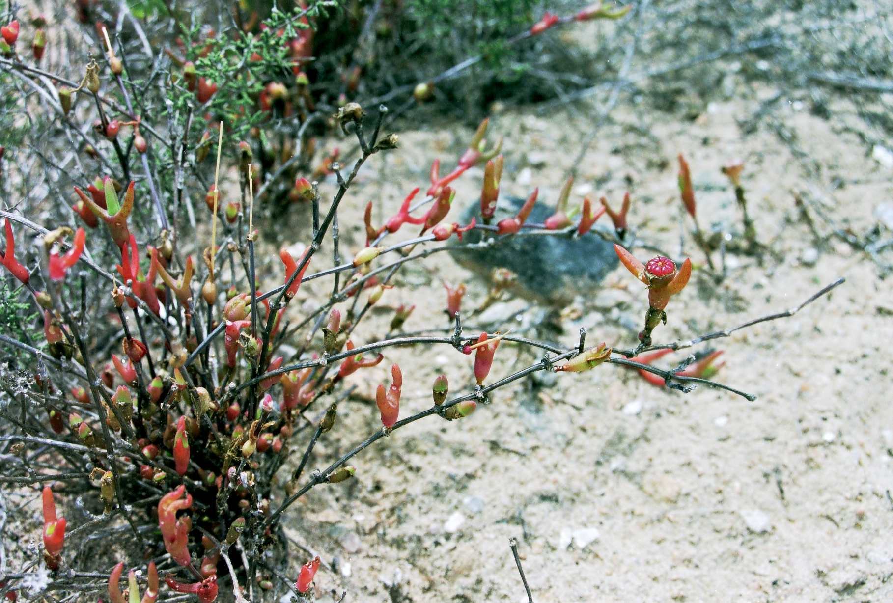
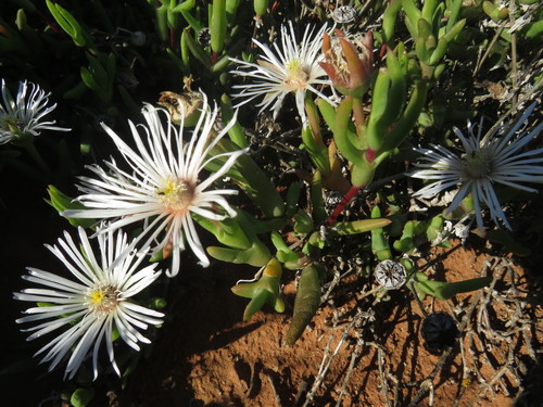
Small, succulent shrub, with a compact centre and long climbing to straggling branches. Leaves differing in shape, first leaf-pair on a branch connate for more than half its length, subsequent ones fused for less than half their length, smooth. Flowers terminal on long-shoots, solitary, 25-40 mm diam., petals white. Fruit 9-12-locular, valve wings broad, closing bodies large. From: Klak, C. 2013. Aizoaceae: Vanzijlia. In: DA Snijman (ed.), Plants of the Greater Cape Floristic Region 2: The Extra Cape flora. Strelitzia 30: 231-231. South African National Biodiversity Institute, Pretoria. [CC BY]
Low, succulent shrublet to 13 cm, with ascending branchlets. Leaves heterophyllous, smooth. Flowers solitary, white or pale pink, 40-60 mm diam. Fruits 9- or 10-locular, with large white closing bodies. From: Klak, C. 2012. Aizoaceae: Vanzijlia L.Bolus. In: J Manning & P Goldblatt (eds), Plants of the Greater Cape Floristic Region 1: The Core Cape flora. Strelitzia 29: 309-309. South African National Biodiversity Institute, Pretoria. [CC BY]
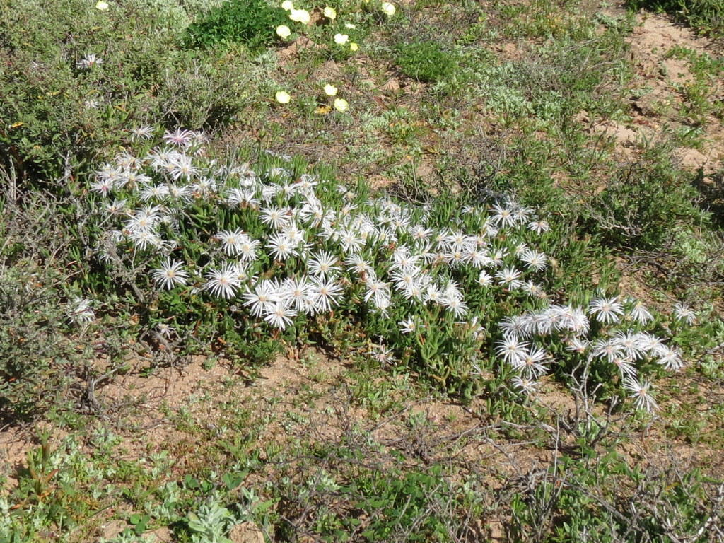
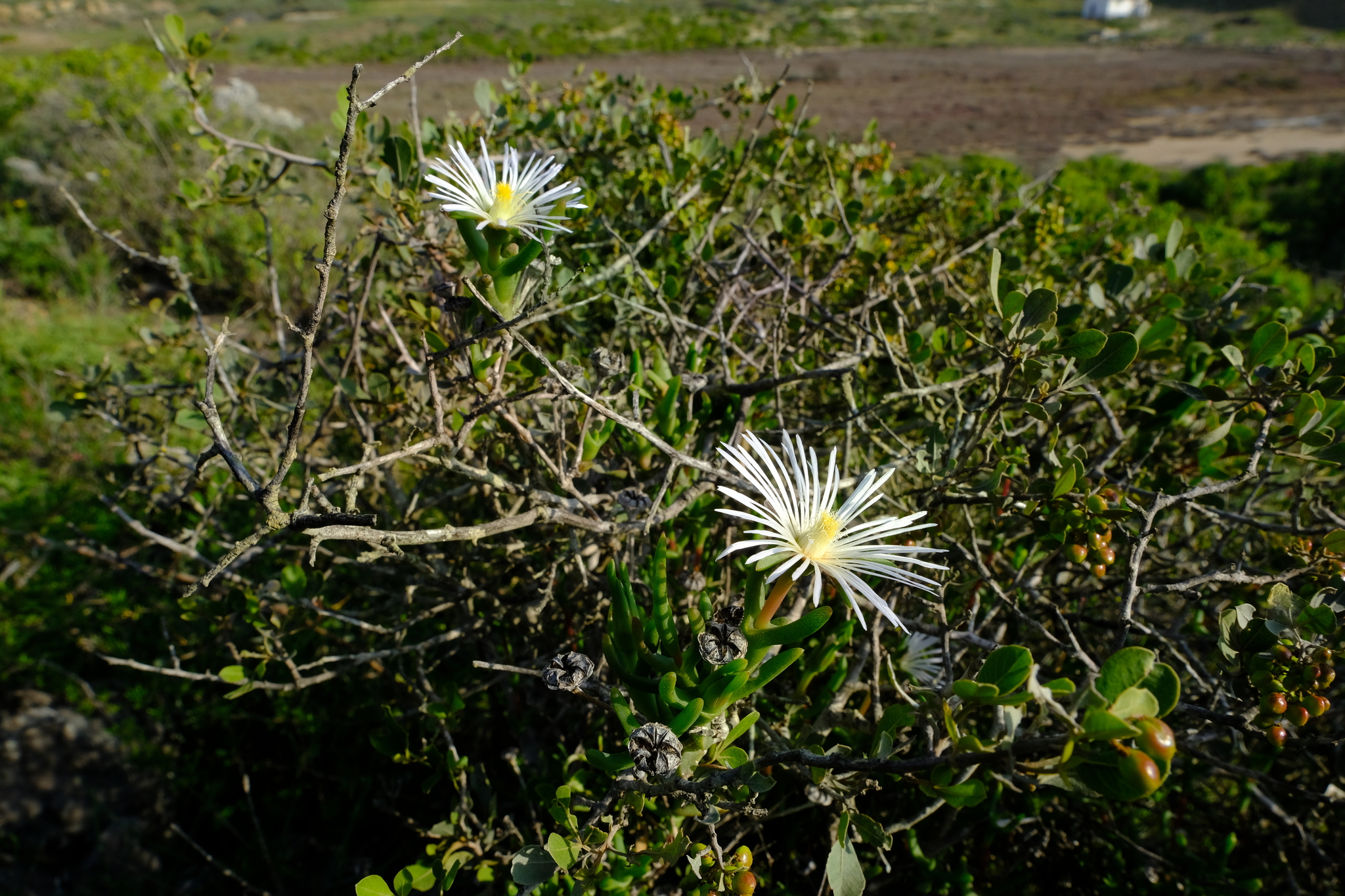
On coastal sands and on loam over calcareous soils. From: Klak, C. 2013. Aizoaceae: Vanzijlia. In: DA Snijman (ed.), Plants of the Greater Cape Floristic Region 2: The Extra Cape flora. Strelitzia 30: 231-231. South African National Biodiversity Institute, Pretoria. [CC BY]
Sand or loam in shrubby vegetation. From: Klak, C. 2012. Aizoaceae: Vanzijlia L.Bolus. In: J Manning & P Goldblatt (eds), Plants of the Greater Cape Floristic Region 1: The Core Cape flora. Strelitzia 29: 309-309. South African National Biodiversity Institute, Pretoria. [CC BY]
From N of Hondeklipbaai to Lambert's Bay. From: Klak, C. 2013. Aizoaceae: Vanzijlia. In: DA Snijman (ed.), Plants of the Greater Cape Floristic Region 2: The Extra Cape flora. Strelitzia 30: 231-231. South African National Biodiversity Institute, Pretoria. [CC BY]
Hondeklip Bay to Lambert's Bay. From: Klak, C. 2012. Aizoaceae: Vanzijlia L.Bolus. In: J Manning & P Goldblatt (eds), Plants of the Greater Cape Floristic Region 1: The Core Cape flora. Strelitzia 29: 309-309. South African National Biodiversity Institute, Pretoria. [CC BY]
July to September
20 to 350 m
This map contains point-based occurrences at different locations
Occurrence in the Flora of Southern Africa (FSA) countries and South African provinces. Residence status indicates if a taxon is indigenous, endemic, naturalised or invasive in a specific region. This data is based on specimen records and literature
FSA
SA
BOT
NAM
ESW
LES
WC
EC
NC
FS
GA
KZN
LP
MP
NW
Absent
Indigenous
Endemic
Naturalised
Invasive

Names and Sources
Vanzijlia angustipetala (L.Bolus) N.E.Br.
Mesembryanthemum annulatum A.Berger
Published in: Bot. Jahrb. Syst. 57(5): 627 (1922)
Mesembryanthemum angustipetalum L.Bolus
Published in: Ann. Bolus Herb. 3: 166 (1924)
Classification
KINGDOM Plantae
SUBKINGDOM Phanerogamae
PHYLUM Anthophyta
ORDER Caryophyllales
FAMILY Aizoaceae
SUBFAMILY Ruschioideae
TRIBE Ruschieae
GENUS Vanzijlia
SPECIES annulata
52 results for Vanzijlia annulata (A.Berger) L.Bolus
Year
Barcode: PRE0686841-0 Collector(s) & number: Van Jaarsveld, EJ, 5708 | 1980-9-10
South Africa, Cape Province, N OF DORINGDRAAI. W SLOPE
Data Resource: BODATSA View record
Barcode: NBG0090572-2 Collector(s) & number: Hall, H, 3735 | 1970-8-11
South Africa, Western Cape, Cape, Hol River,15 miles north of Vredendal
Data Resource: BODATSA View record
Barcode: PRE0890930-0 Collector(s) & number: Nienaber, EP, EN815 | 2000-6-19
South Africa, Western Cape, Lutzville due west to Robeiland. Trans Hex Mine just north of Olifants River mouth.
Data Resource: BODATSA View record
Barcode: PRE0761922-0 Collector(s) & number: Burgoyne, PM, 10549 | 2006-9-18
South Africa, Western Cape, Vredendal District. ± 4 km S of Doringbaai.
Data Resource: BODATSA View record
Barcode: NBG0802256-0 Collector(s) & number: Chinnock, RJ, 9212 | 1998-9-5
South Africa, Western Cape, Western Cape, 6.8 km south west of Lutzville on the Strandfontein road.
Data Resource: BODATSA View record
Barcode: PRE0757453-0 Collector(s) & number: Bester, SP, 6958 | 2006-7-30
South Africa, Northern Cape, Namaqua National Park. Proposed westcoast section. Northwestern corner of Strandfontein farm.
Data Resource: BODATSA View record
Barcode: PRE0761923-0 Collector(s) & number: Burgoyne, PM, 10518 | 2006-9-16
South Africa, Western Cape, Vredendal District. W of Lutzville, ± 100 m from crossroads to Nuwerus.
General notes: Strandveld. Slope: gentle. Common to abundant. Quaternary deposits. Height: ± 10-45 cm. Tangled shrublets with stems rooting where they touch the ground.
Data Resource: BODATSA View record
Barcode: PRE0509821-0 Collector(s) & number: Burgoyne, PM, 7850 | 2000-1-7
South Africa, Western Cape, Vredendal District: Strandfontein at T- junction going into town.
Data Resource: BODATSA View record
Barcode: PRE0803070-0 Collector(s) & number: Van Rooyen, MW, 2115 | 1992-9-29
South Africa, Western Cape, Van Rhynsdorp/Vredendal: Brandsebaai. Proposed mining area (for heavy minerals) of Anglo American Corporation: Strandveld of West Coast.
General notes: Det: M. Jordaan
Data Resource: BODATSA View record
Barcode: NBG0142437-0 Collector(s) & number: Thomas, M, 9031 | 1986-10-7
South Africa, Northern Cape, Cape, Calvinia, Van Rhynshoek, east bottom of Hantam
Data Resource: BODATSA View record
Barcode: PRE0577223-0 Collector(s) & number: Burgoyne, PM, 7553 | 1999-9-6
South Africa, Western Cape, Vredendal District: Strandfontein at T-junction into the town.
General notes: Nama Karoo. Coastal succulent scrubland. Coastal plain. Soil. Well-drained. Sand. Sandstone. Full sun. Slope: none. Biotic effect: none seen. Succulent, ± 30 - 40 cm high. Straggling with stems between other bushes. Flowers light cream. Fruit absent. Occasional.
Data Resource: BODATSA View record
Barcode: NBG0202313-0 Collector(s) & number: Desmet, PG, 1364 | 1997-9-20
South Africa, Western Cape, Namaqualand. Bakoondkolk. Bitterfontein. Quartz lag, gravel patches north of dirt road, on the eastern bank of Bakoondkolk River.
General notes: 31°01'19"S: 18°24'04"E. Low Succulent Karoo. Quartz lag gravel over silcrete. Well-drained, stony, clay amd loam soil. Full sun. Moderate slope. SW aspect.
Data Resource: BODATSA View record
Barcode: PRE0853889-0 Collector(s) & number: Steyn, HM, 1787 | 2010-9-5
South Africa, Northern Cape, Namaqualand District. Namaqua National Park. S of Koringkorrelbaai; between Spoegrivier & Groenrivier.
General notes: Coastal plain. Slope: gentle. White flowers - prostrate growing.
Data Resource: BODATSA View record
Barcode: PRE0772897-0 Collector(s) & number: Steyn, HM, 1250 | 2007-8-10
South Africa, Northern Cape, Namaqualand District. De Beers Mining Area, NW of Koingnaas on road to Kleinsee.
General notes: Namaqualand Coastal Duneveld. Slope: none. Coastal plain. Internodes red.
Data Resource: BODATSA View record
Barcode: NBG0142080-0 Collector(s) & number: Van Jaarsveld, EJ, 5115 | 1980-9-10
South Africa, Western Cape, Cape, 1 km from Lutzville laagwater bridge towards Hol River
Data Resource: BODATSA View record
Barcode: NBG0127967-0 Collector(s) & number: Van Jaarsveld, EJ, 5686 | 1980-9-9
South Africa, Western Cape, Cape, 5 km from Elandsbay towards Velddrif
Data Resource: BODATSA View record
Barcode: NBG0802257-0 Collector(s) & number: Euston-Brown, D, 30 | 1999-10-10
South Africa, Western Cape, Western Cape, West Coast, within 200 m of coastline, proposed Liebenberg Bay Mine, 35 km west of Koekenaap
Data Resource: BODATSA View record
Barcode: NBG0089986-0 Collector(s) & number: Wisura, W, 903 | 1969-11-24
South Africa, Northern Cape, Cape, Hondeklipbaai, Kotzesrus, on granite hill just south of the village
Data Resource: BODATSA View record
Barcode: PRE0559361-0 Collector(s) & number: Boucher, C, 4052 | 1978-11-8
South Africa, Western Cape, CLANWILLIAM DIST.; DORINGBAAI; BAMBOESBAAI
Data Resource: BODATSA View record
Barcode: NBG0275539-0 Collector(s) & number: Helme, NA, 7440 | 2012-7-18
South Africa, Western Cape, Vanrhynsdorp Dist. 30 km W of Nuwerus. Komkans 141. 2 km SE of Komkans farm. 31°13'19.0"S 18°05'39.4"E.
General notes: Alt. 160 m. Succulent Karoo. Namaqualand Heuweltjieveld. Hill slope. No slope. Soil. Well-drained. Sand loam. Full sun. No biotic effect seen. Succulent, 0.2 m. Flowers present. Fruit present. White, recurved petals, cone brownish. Scattered plants in sands over dorbank.
Data Resource: BODATSA View record
Barcode: NBG0169995-0 Collector(s) & number: Boucher, C, 5470 | 1989-3-11
South Africa, Cape Province, Southern Namaqualand. Graauwduinen, Anglo Exploration Trench 93. Red sandy flats.
General notes: Acock's veld type 34. Open shrubland. Plain. Slope level. Sandy soil. Aspect: none. Soil well-drained. Procumbent. Fairly common. Voucher for physiological experiments.
Data Resource: BODATSA View record
Barcode: PRE0803516-0 Collector(s) & number: Goldblatt, P, 3639 | 1976-7-21
South Africa, Western Cape, Van Rhynsdorp; 3km South of Nuwerus, North side of Main Road - Quartzite Gravel.
General notes: Det: M. O'Connor Fenton
Data Resource: BODATSA View record
Barcode: NBG0090572-1 Collector(s) & number: Hall, H, 3735 | 1970-8-11
South Africa, Western Cape, Cape, Hol River,15 miles north of Vredendal
Data Resource: BODATSA View record
Barcode: NBG0802255-0 Collector(s) & number: Bolus, L, s.n. | 1938-9-
South Africa, Western Cape, Cape Region, Clanwilliam District, Lamberts Bay
Data Resource: BODATSA View record
Barcode: NBG0077186-1 Collector(s) & number: Hall, H, 2855 | 1964-9-5
South Africa, Western Cape, Cape province, Van Rhynsdorp District, Doringbaai
Data Resource: BODATSA View record
Barcode: NBG0802254-0 Collector(s) & number: Hall, H, 2865 | 1964-9-5
South Africa, Western Cape, Cape Province, Van Rhynsdorp District, Doringbaai
Data Resource: BODATSA View record
Barcode: NBG0127968-0 Collector(s) & number: Van Jaarsveld, EJ, 5712 | 1980-9-10
South Africa, Western Cape, Cape, 4 km from Lutzville (Vlermuisklip) towards Papendorp, top of hill
Data Resource: BODATSA View record
Barcode: NBG0142151-0 Collector(s) & number: Van Jaarsveld, EJ, 5708 | 1980-9-10
South Africa, Western Cape, Cape, North of Doringbaai.
Data Resource: BODATSA View record
Barcode: NBG0077186-2 Collector(s) & number: Hall, H, 2865 | 1964-9-5
South Africa, Western Cape, Cape province, Van Rhynsdorp District, Doringbaai
Data Resource: BODATSA View record
Barcode: NBG0198128-0 Collector(s) & number: Burgoyne, PM, 7553 | 1999-9-6
South Africa, Western Cape, Vredendal District: Strandfontein at T-junction into the town.
General notes: Nama Karoo. Coastal succulent scrubland. Coastal plain. Soil. Well-drained. Sand. Sandstone. Full sun. Slope: none. Biotic effect: none seen. Succulent, ± 30 - 40 cm high. Straggling with stems between other bushes. Flowers light cream. Fruit absent. Occasional.
Data Resource: BODATSA View record
Barcode: PRE0574121-0 Collector(s) & number: Burgoyne, PM, 8778 | 2001-11-20
South Africa, Western Cape, Clanwilliam District. Lamberts Bay.
General notes: Fynbos. Dune (coastal) covering granite dome. Stony soil. Well drained. Receiving sea fog. Gravel. Granite. Full sun. Gentle slope. W aspect. Biotic effect: disturbed, litter. Succulent. ± 30 cm tall. Upright stems with young internodes rust/red. Flowers absent. Fruit present. Common.
Data Resource: BODATSA View record
Barcode: PRE0761921-0 Collector(s) & number: Burgoyne, PM, 10526(b) | 2006-9-18
South Africa, Western Cape, Vredendal District. S of Lutzville. Open ground NW of Papendorp turn.
Data Resource: BODATSA View record
Barcode: NBG0207757-0 Collector(s) & number: Burgoyne, PM, 10392 | 2005-12-3
South Africa, Western Cape, Piquetberg District. Elands Bay below cliff above harbour.
General notes: Strandveld. Lower mountain slope. Height ± 20-40 cm. Straggling with leaves forming a sheath for lower part. Voucher for seed germination studies (UP).
Data Resource: BODATSA View record
Barcode: NBG0250380-0 Collector(s) & number: Desmet, PG, 13645 | 2007-8-30
South Africa, Northern Cape, Namaqualand coast. Schulpfontein farm, Little fence in distance over road from beach area. 30°04'49.3"S 17°17'900"E.
General notes: Namaqualand strandveld. Coastal plain. In well-drained recent sands and full sun. No biotic effect seen. Gentle slopes. Succulent karoo. White flowers and fruit absent. Plant height: 15 cm tall.
Data Resource: BODATSA View record
Barcode: PRE0755066-0 Collector(s) & number: Burgoyne, PM, 10392 | 2005-12-3
South Africa, Western Cape, Piquetberg District. Elands Bay below cliff above harbour.
General notes: Strandveld. Lower mountain slope. Height ± 20-40 cm. Straggling with leaves forming a sheath for lower part. Voucher for seed germination studies (UP).
Data Resource: BODATSA View record
Barcode: NBG02777751-0 Collector(s) & number: Low, AB, ABL12940 | 2006-11-7
South Africa, Western Cape, St Helena Fields. Saldanha Peninsula. 32°46'110" S; 18°01'763" E.
General notes: Fynbos biome. Saldanha Granite Strandveld vegetation. Hilltop, moderate, hill slope. Well-drained, loam, rocky soil. Granite. Full sun. No biotic effect seen. Succulent. Pink flowers. Plant height 0.60 m.
Data Resource: BODATSA View record
Barcode: PRE0765223-0 Collector(s) & number: Burgoyne, PM, 8163 | 2001-2-9
South Africa, Western Cape, Vanrhynsdorp District; ±47 km N of Vanrhynsdorp on Knersvlakte.
General notes: Calcrete. Slope: gentle.
Data Resource: BODATSA View record
Barcode: NBG1474367-0 Collector(s) & number: Burgoyne, PM, 8163 | 2001-2-9
South Africa, Western Cape, Vanrhynsdorp District; ±47 km N of Vanrhynsdorp on Knersvlakte.
General notes: Calcrete. Slope: gentle.
Data Resource: BODATSA View record
Barcode: PRE0686845-0 Collector(s) & number: Van Jaarsveld, EJ, 5115 | 1980-9-10
South Africa, Western Cape, 1 KM FROM LUTZVILLE LAAGWATER BRIDGE TO HOL RIVER. SLIGHT SE-SLOPE.
Data Resource: BODATSA View record
Barcode: PRE0755049-0 Collector(s) & number: Burgoyne, PM, 10390 | 2005-12-3
South Africa, Western Cape, Clanwilliam District. Lamberts Bay on seashore.
General notes: Strandveld. Conglomerate. Gravelly sand. Slope: gentle. Height ± 20-50 cm. Straggling in other plants or growing alone. Common in spots.
Data Resource: BODATSA View record
Barcode: PRE0398356-0 Collector(s) & number: Exp. Farm Nortier, 1657 | 1964-9-11
South Africa, Western Cape, STELLENBOSCH DIV.
Data Resource: BODATSA View record
Barcode: PRE0772865-0 Collector(s) & number: Steyn, HM, 1310 | 2007-8-11
South Africa, Northern Cape, Namaqualand District. Koingnaas-Kleinsee road.
General notes: Namaqualand Coastal Duneveld. Coastal plain. Slope: none. Sparse leaves.
Data Resource: BODATSA View record
This map contains point-based occurrences at different locations
2013
SERIES CHAPTER
Aizoaceae: Vanzijlia Klak, CIn: DA Snijman (ed.), Plants of the Greater Cape Floristic Region 2: The Extra Cape flora. Strelitzia 30: 231-231
South African National Biodiversity Institute, Pretoria
2012
SERIES CHAPTER
Aizoaceae: Vanzijlia L.Bolus Klak, CIn: J Manning & P Goldblatt (eds), Plants of the Greater Cape Floristic Region 1: The Core Cape flora. Strelitzia 29: 309-309
South African National Biodiversity Institute, Pretoria
2001
BOOK
Illustrated handbook of succulent plants: Aizoaceae F-Z Hartmann, HEKO1983
PERIODICAL/JOURNAL
Hartmann, HEKOBotanische Jahrbücher für Systematik, Pflanzengeschichte und Pflanzengeographie 103:
1927
PERIODICAL/JOURNAL
Vanzijlia annulata L.Bolus Bolus, L; Page, MMFlowering Plants of South Africa 7: , t.262
No results found for Vanzijlia annulata (A.Berger) L.Bolus
Status and criteria
LC
Assessor(s)
Plantae Coordinator
| Part(s) of plant used | Use(s) | Reference |
|---|
Coming soon...
