PLANTAE / PHANEROGAMAE / ANTHOPHYTA / CARYOPHYLLALES / AIZOACEAE / RUSCHIOIDEAE / RUSCHIEAE / CHEIRIDOPSIS / DENTICULATA

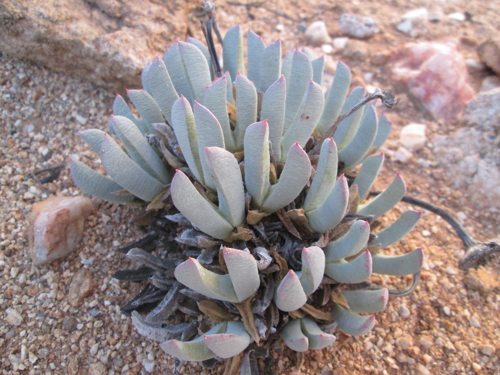
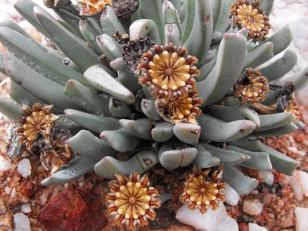
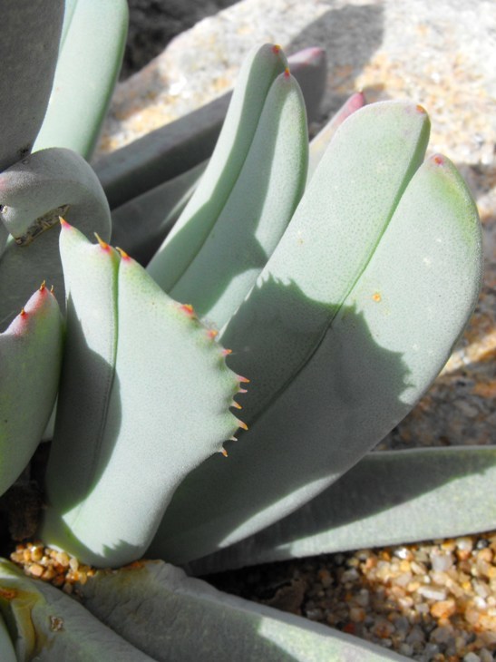
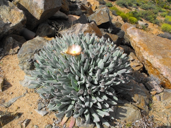
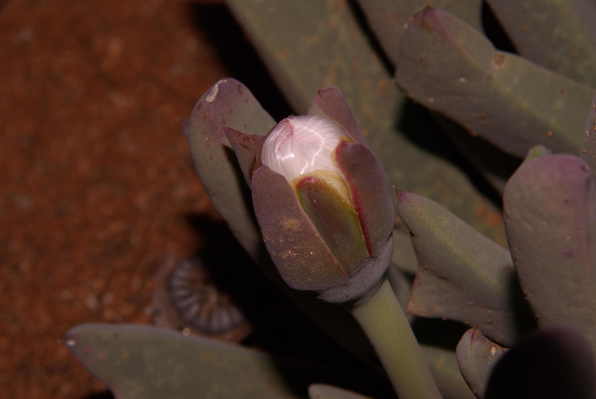
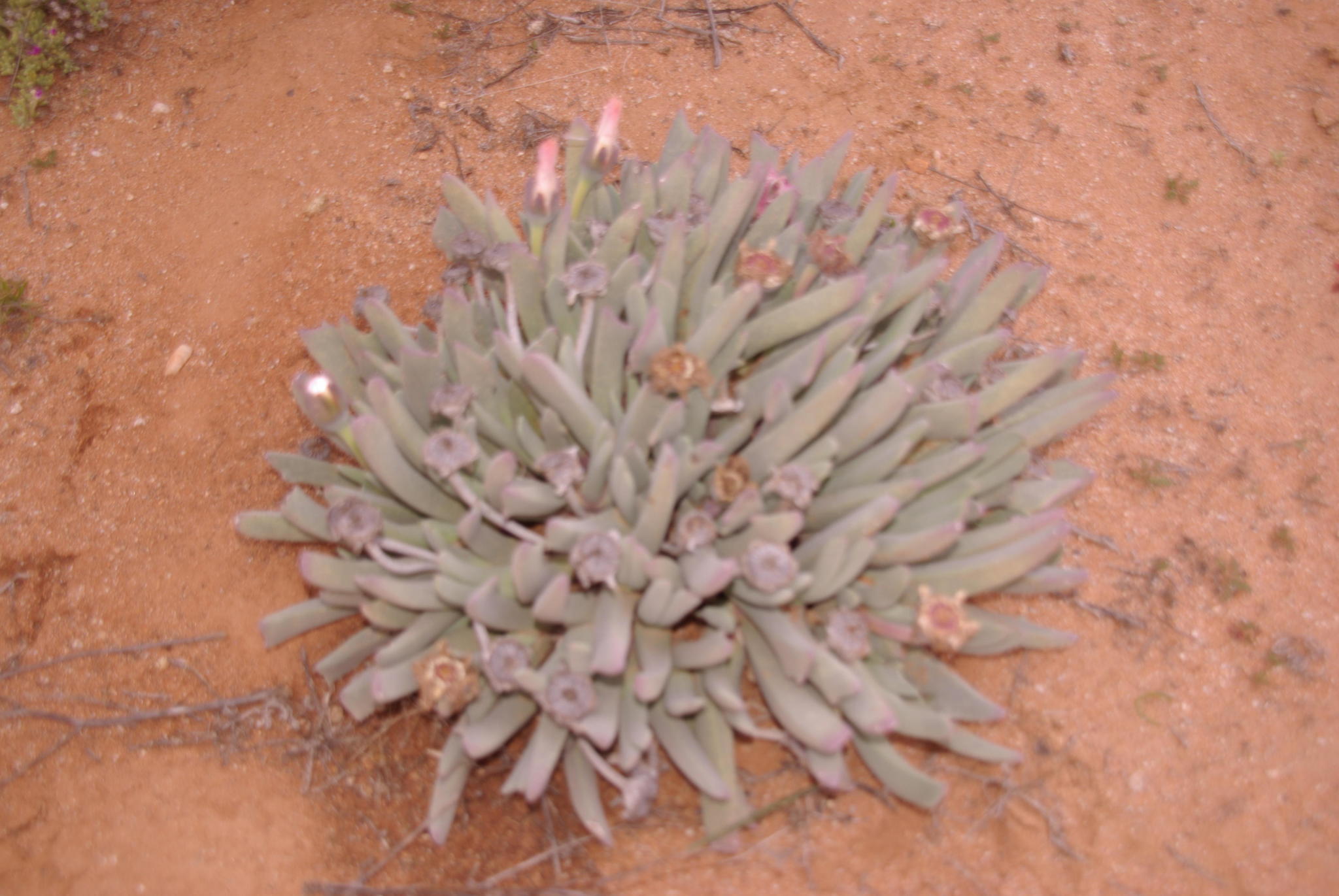
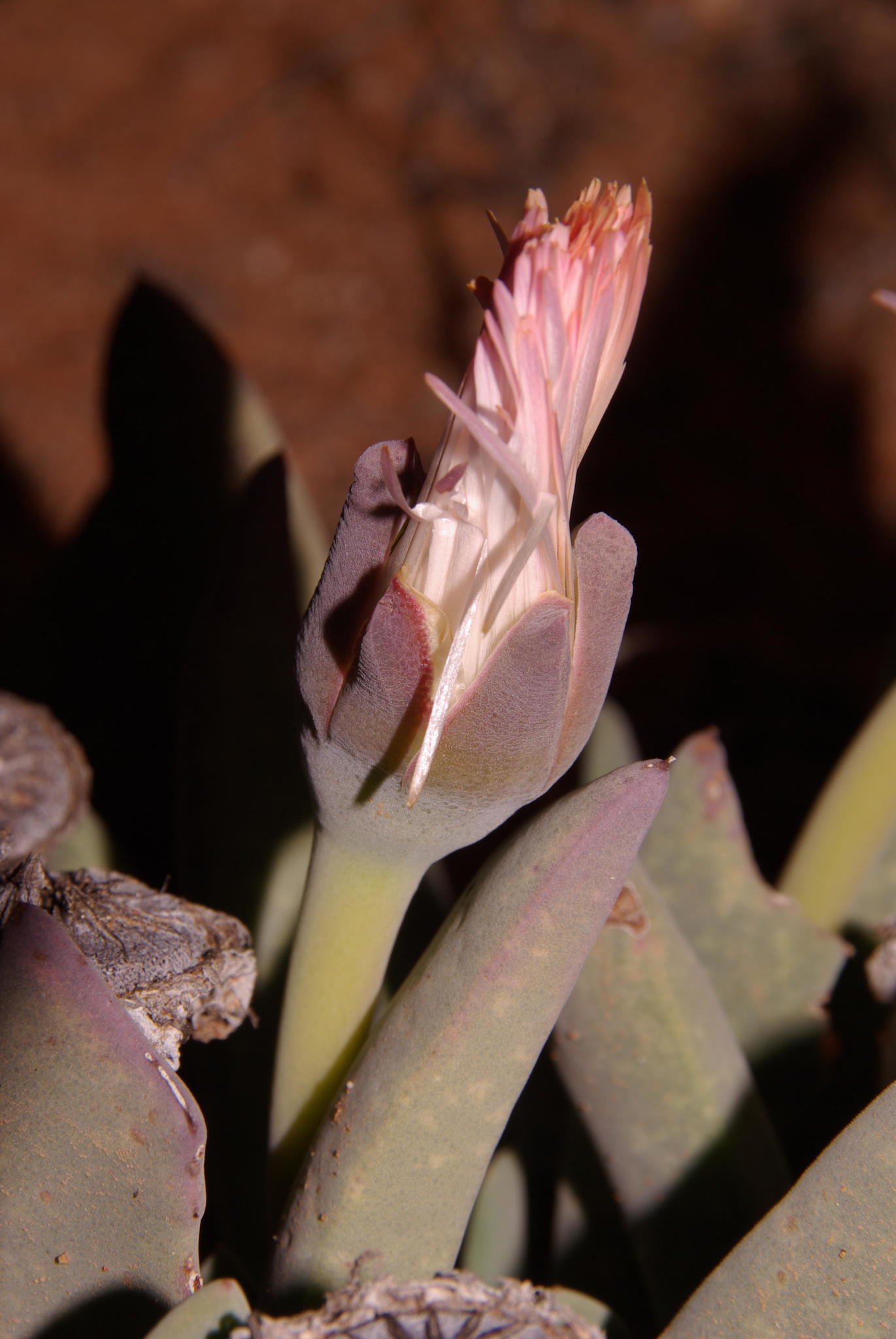
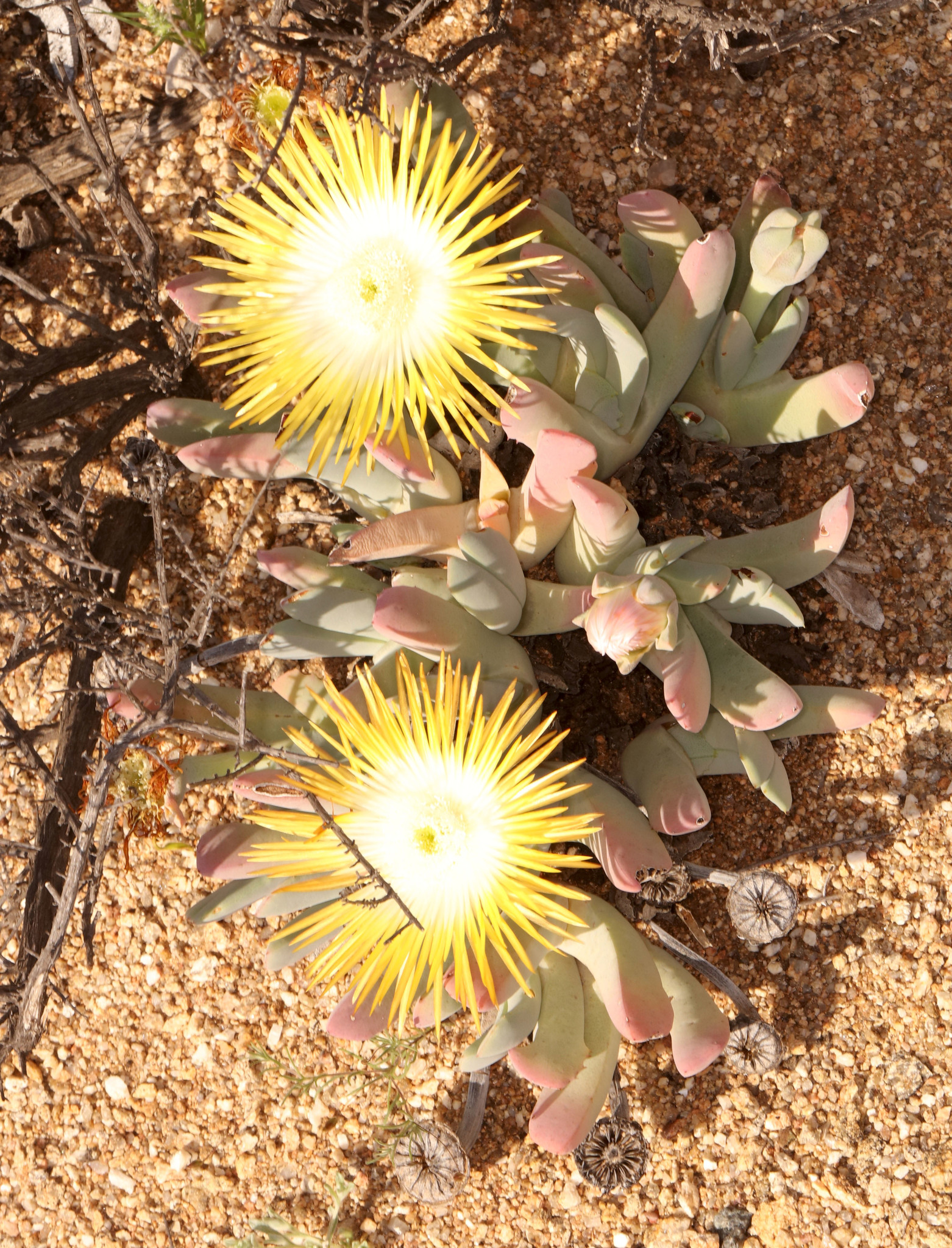
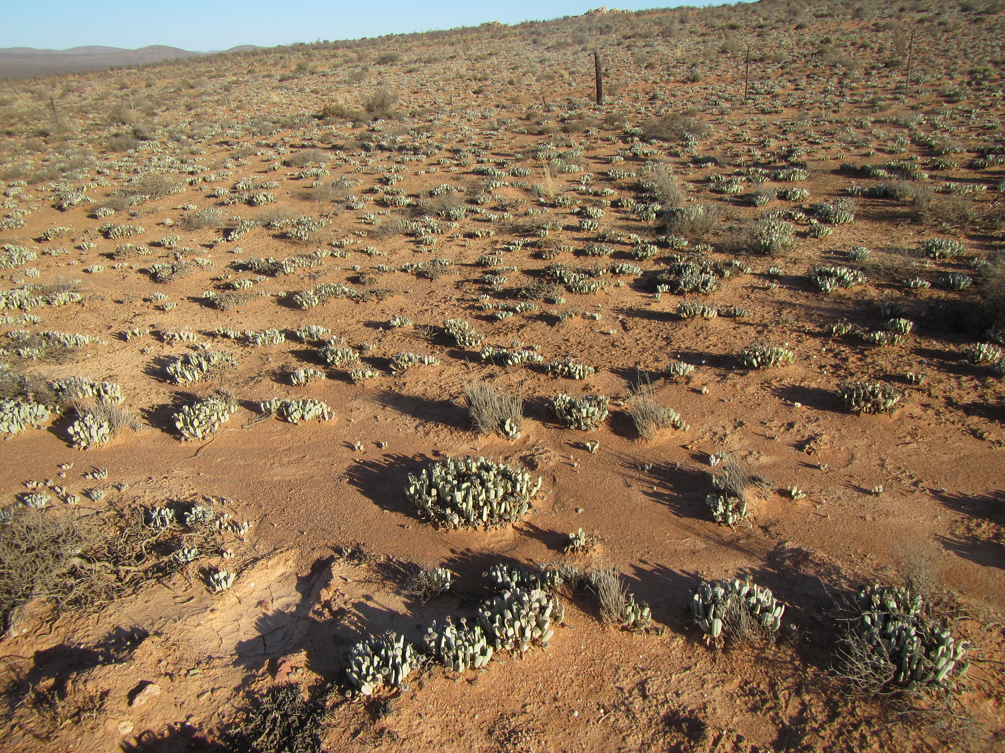
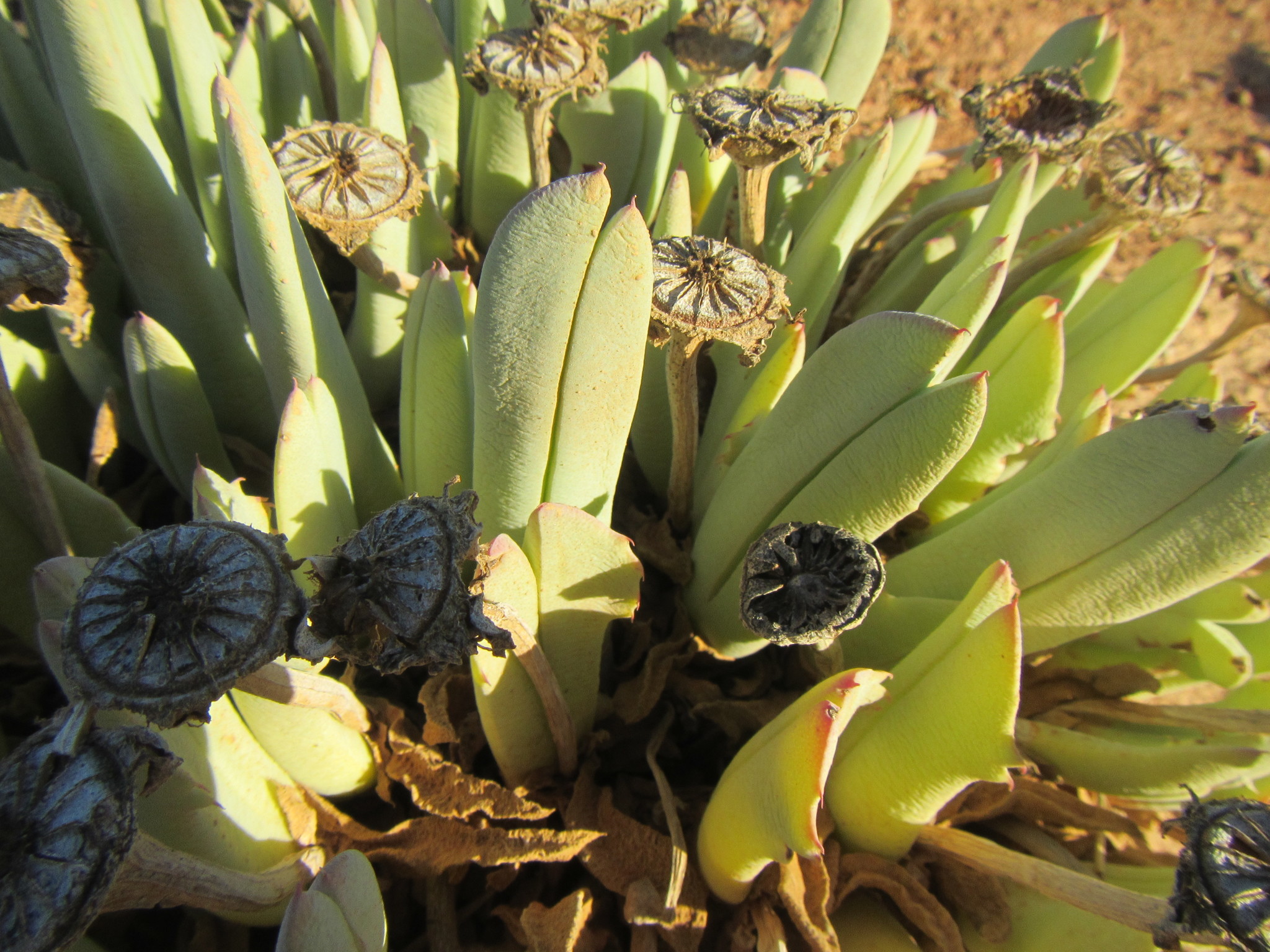
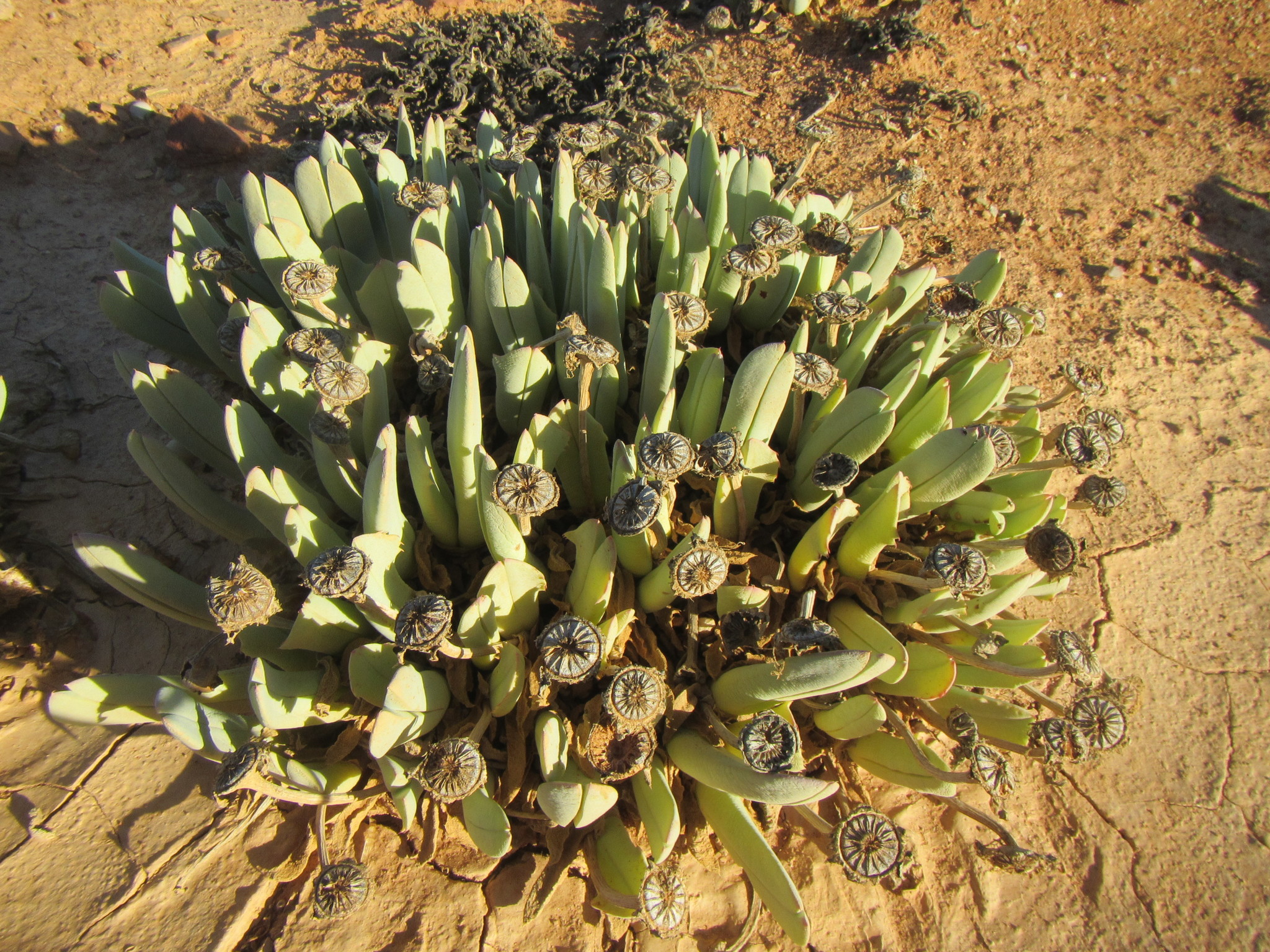
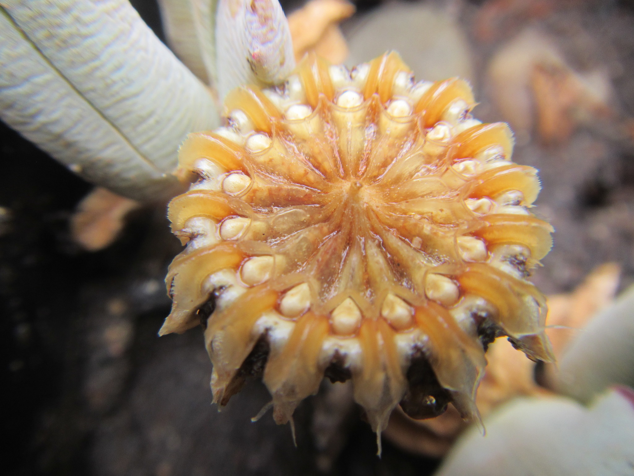
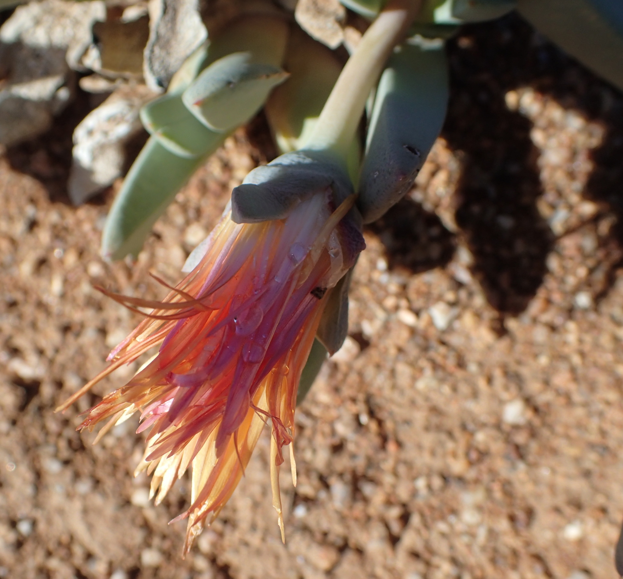
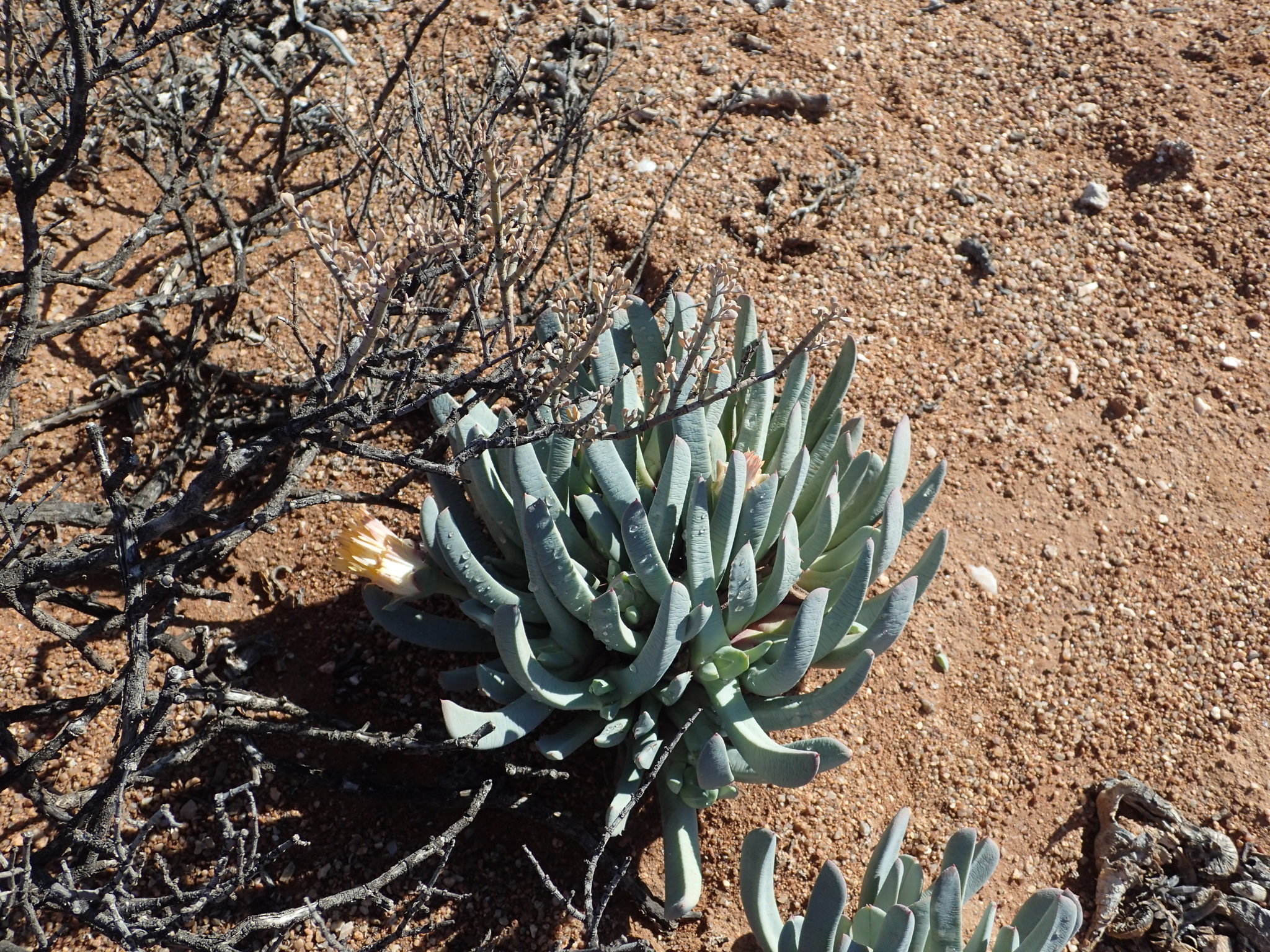
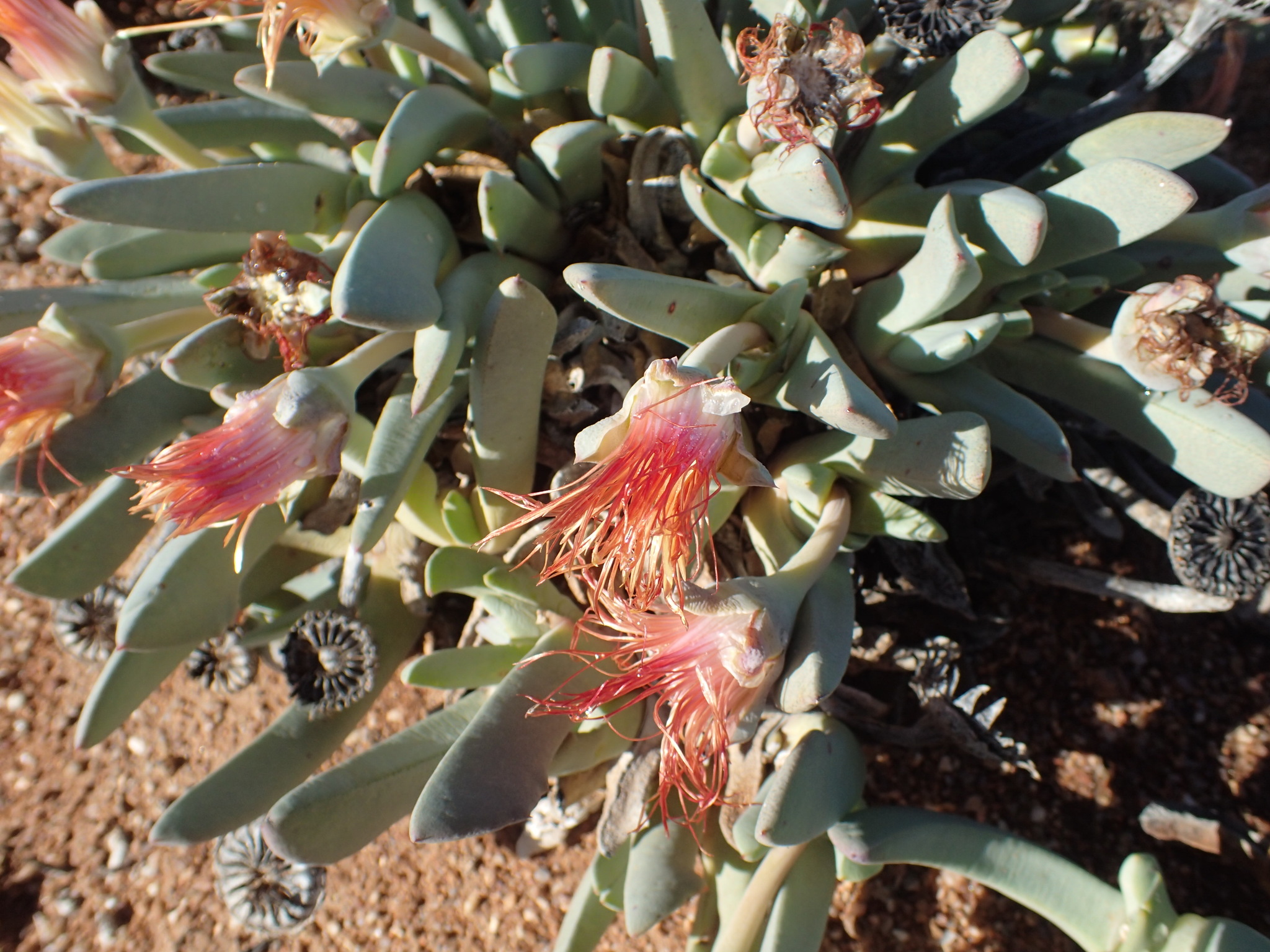
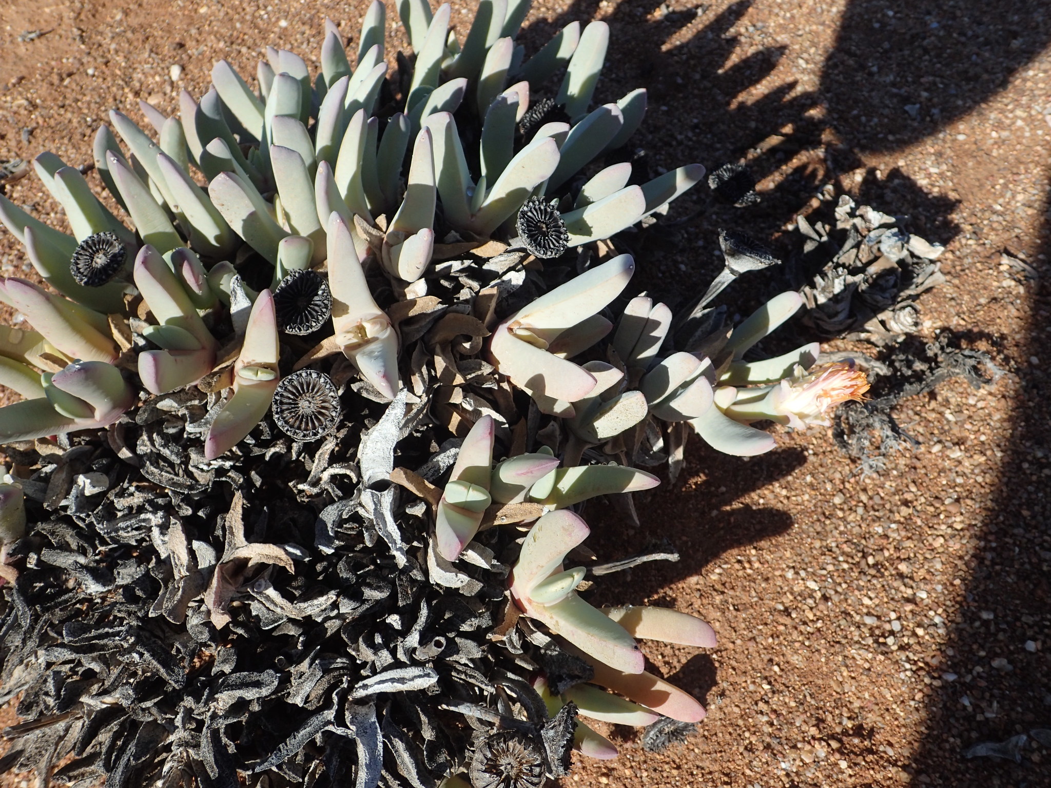
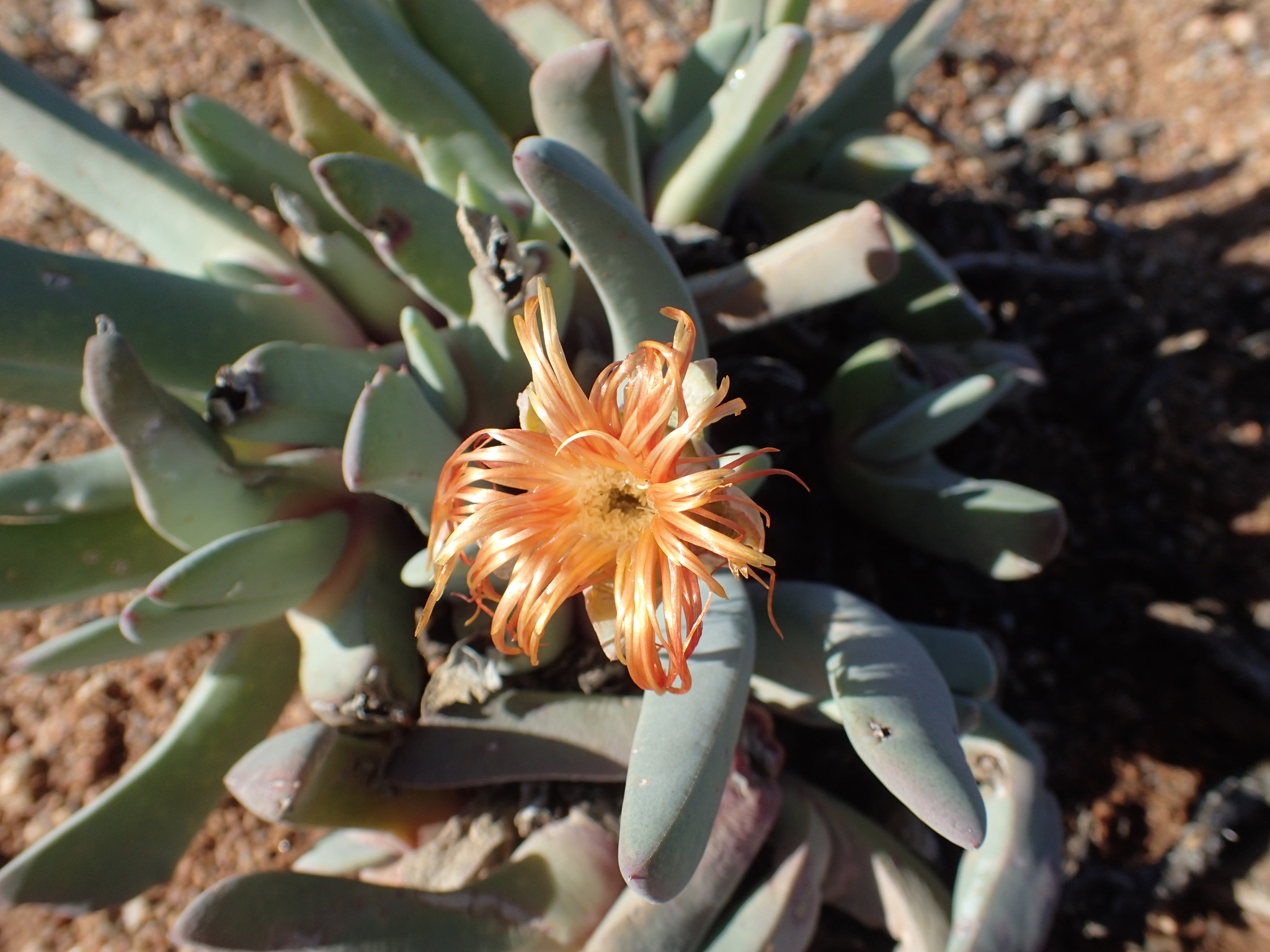
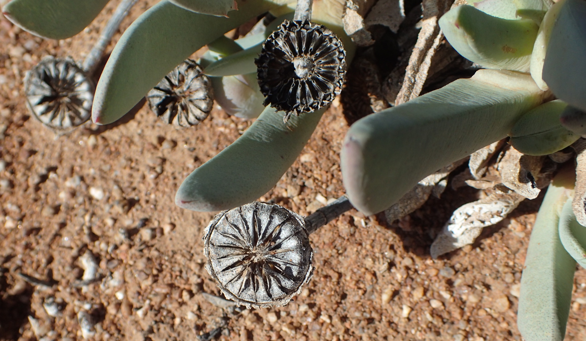
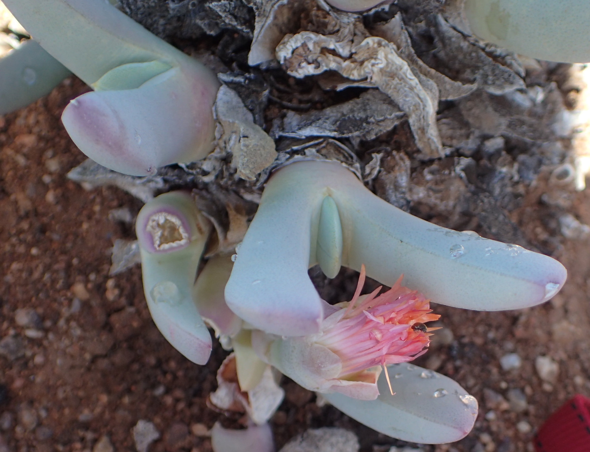
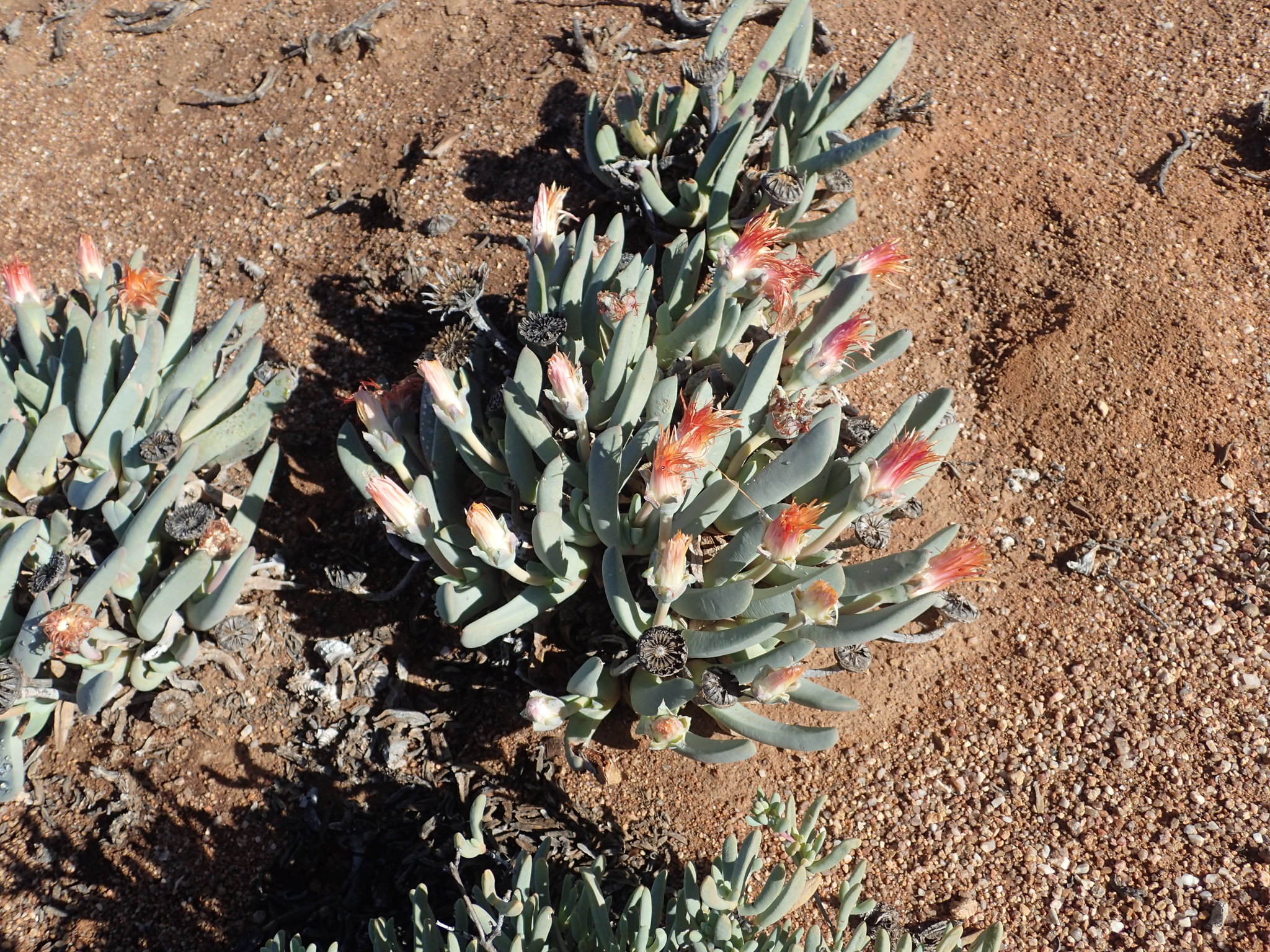
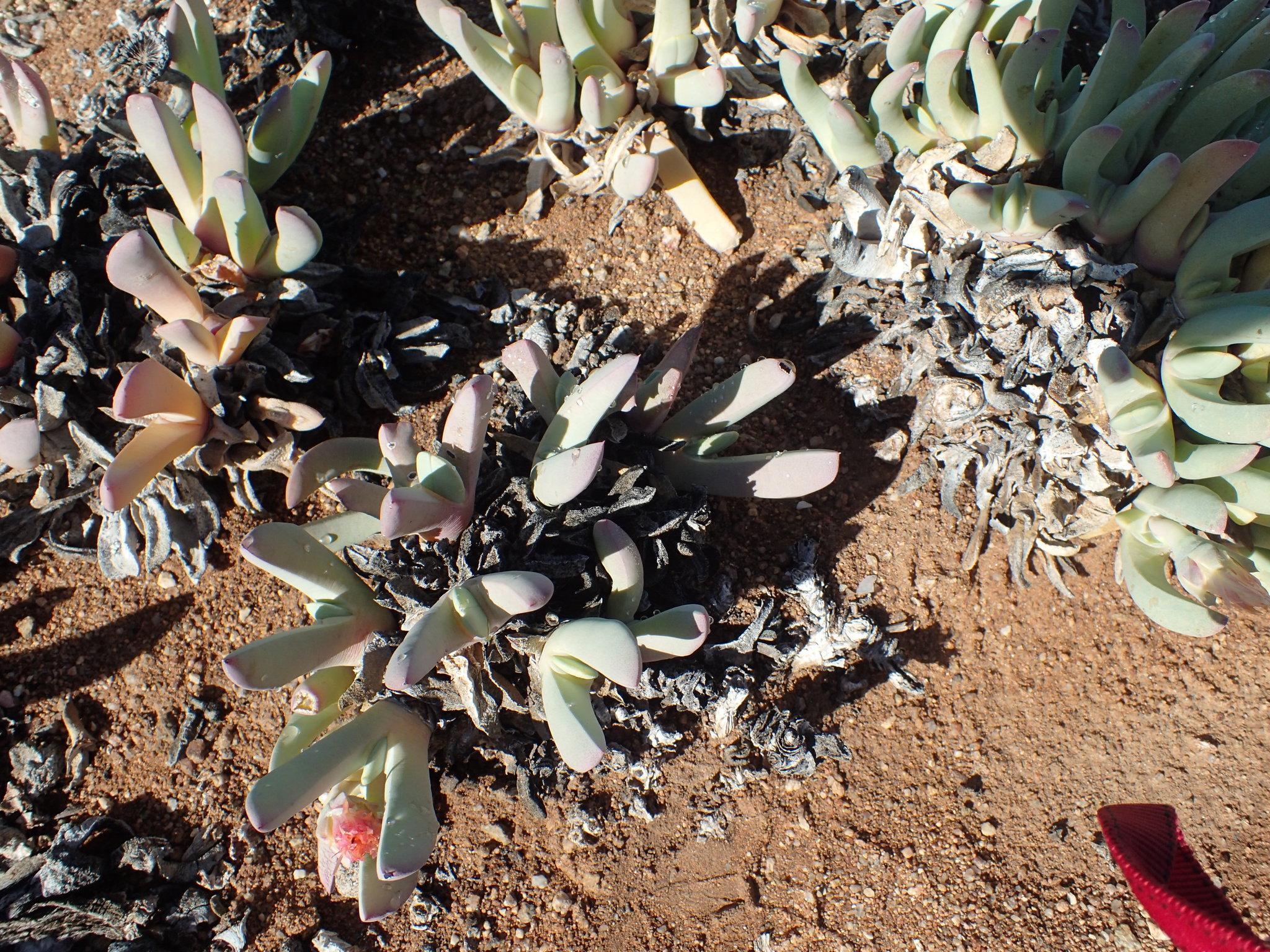
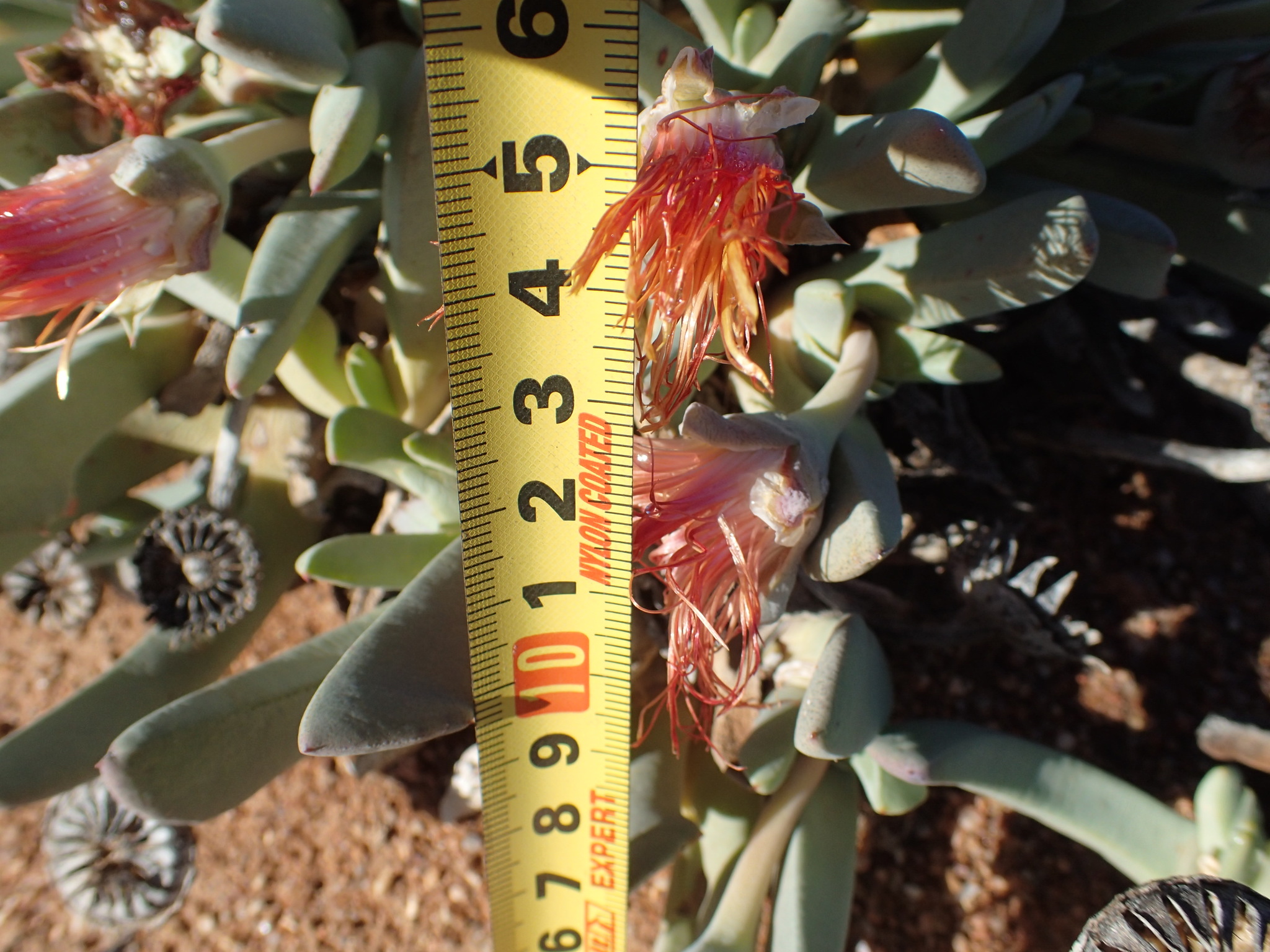
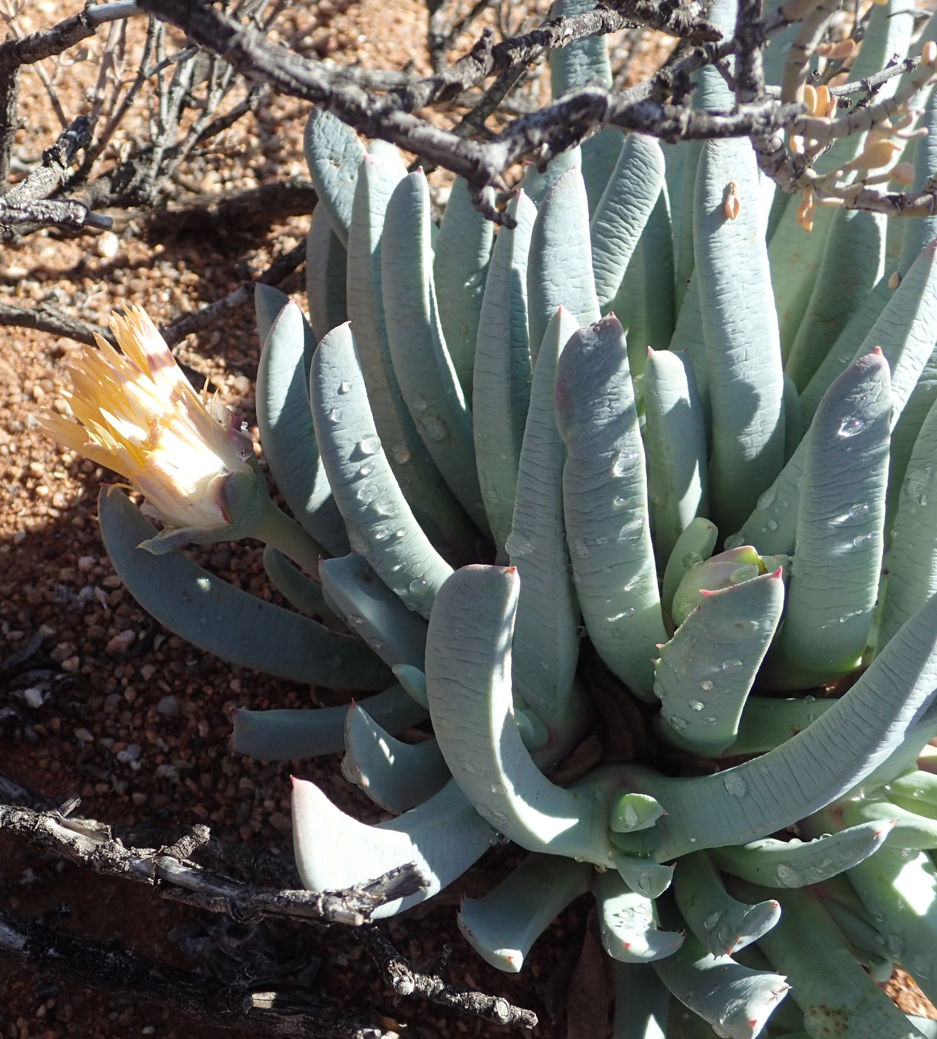
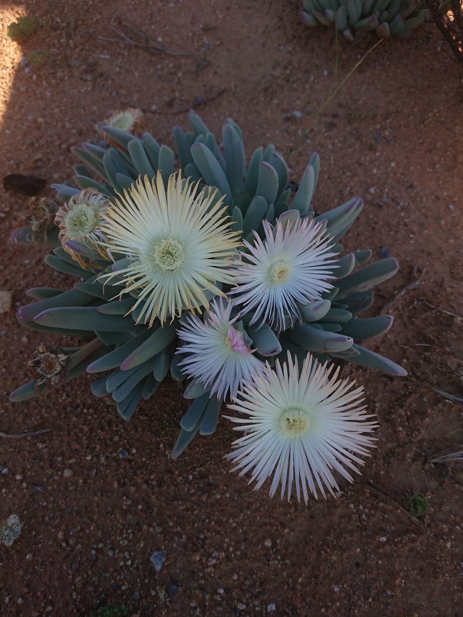
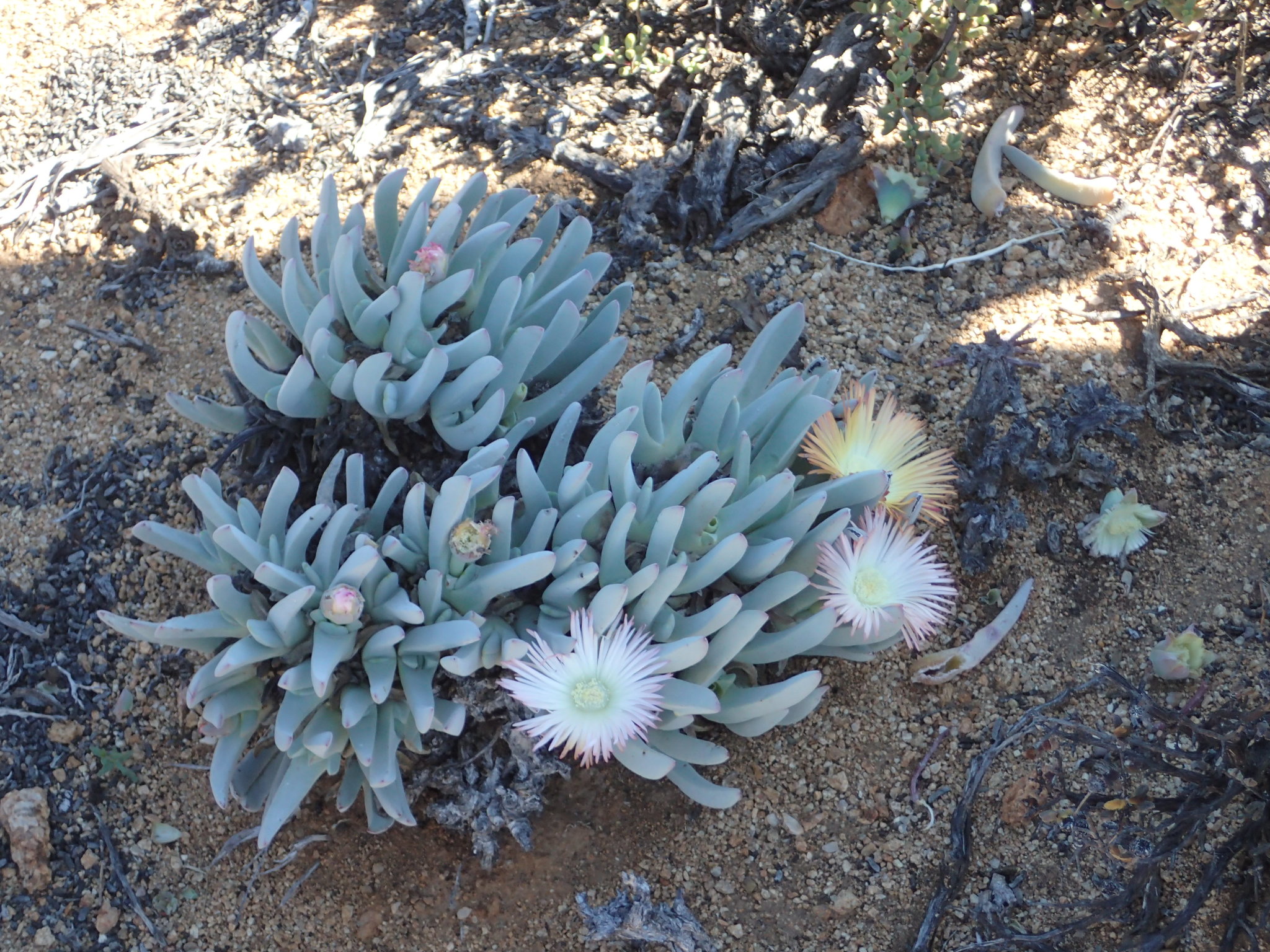
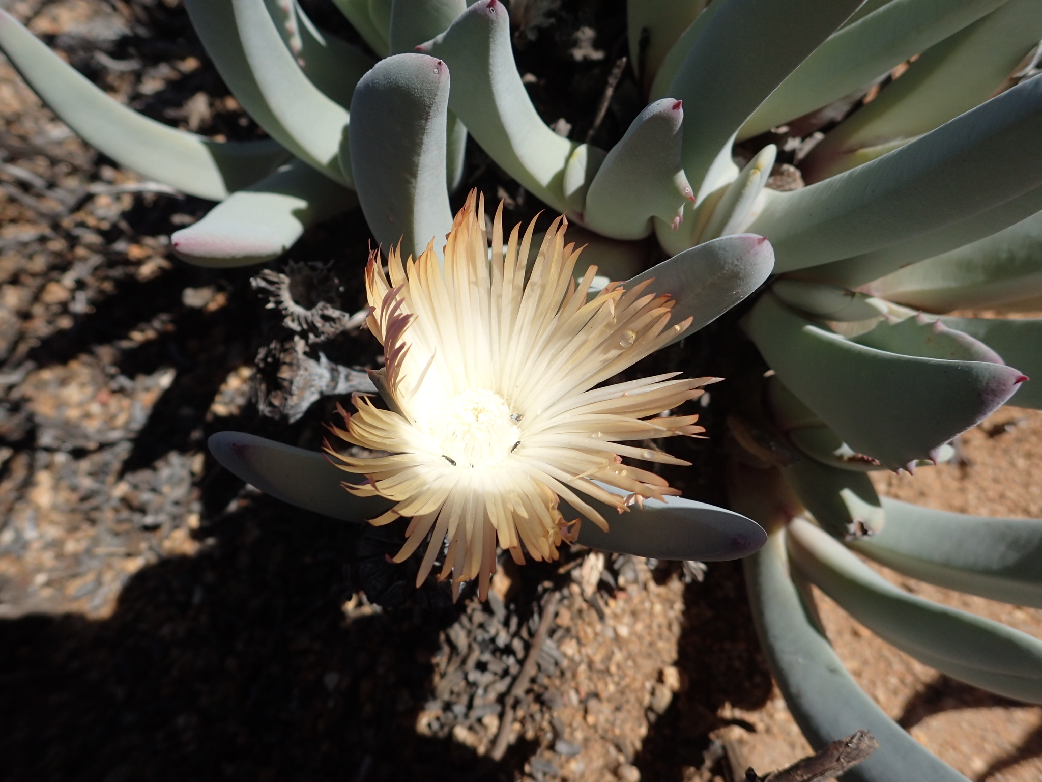
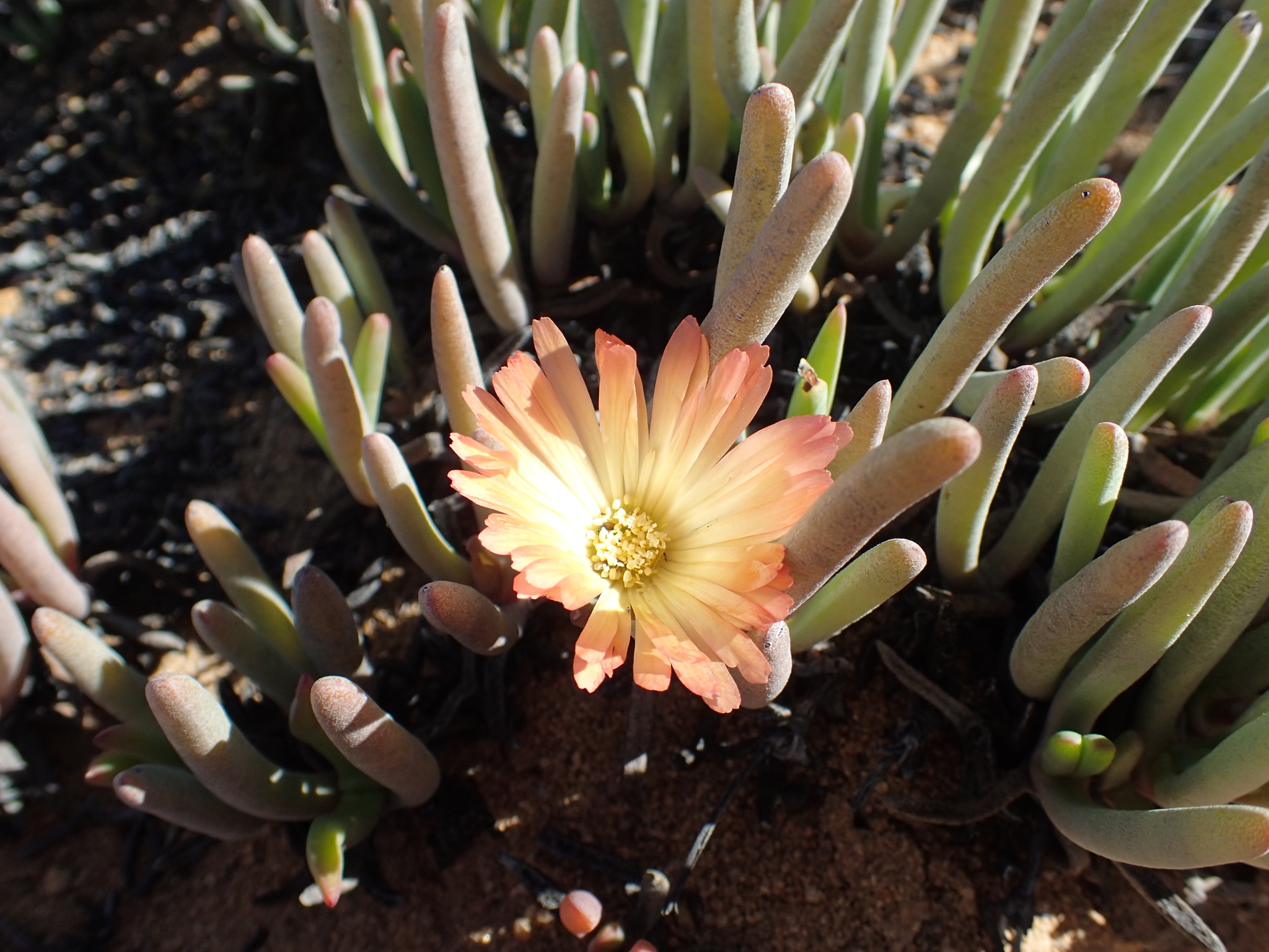
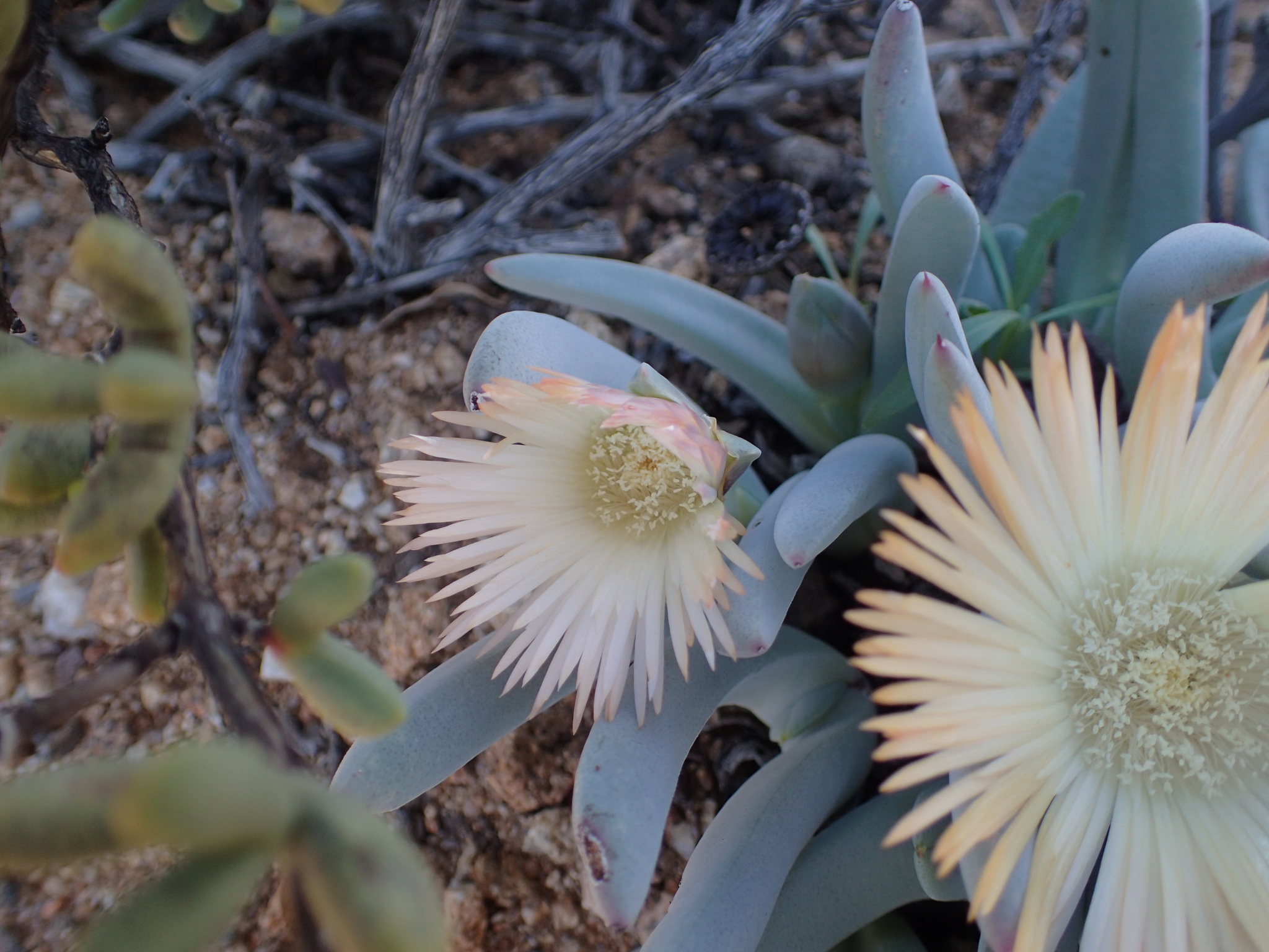
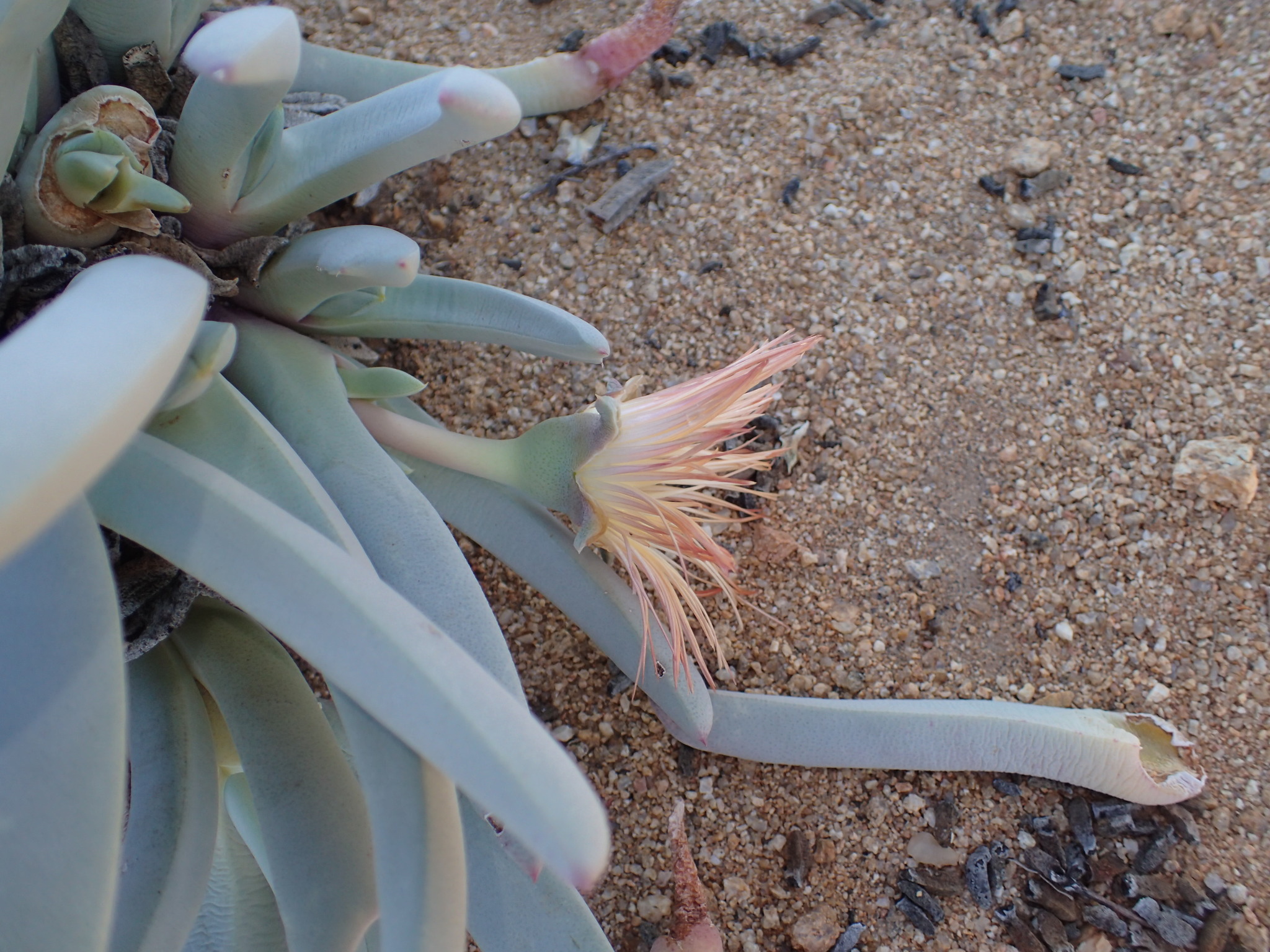
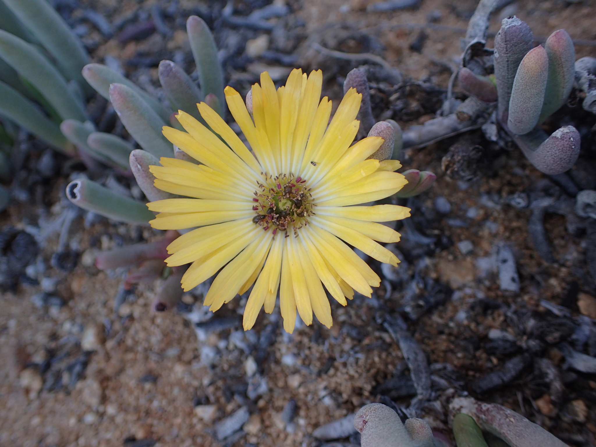
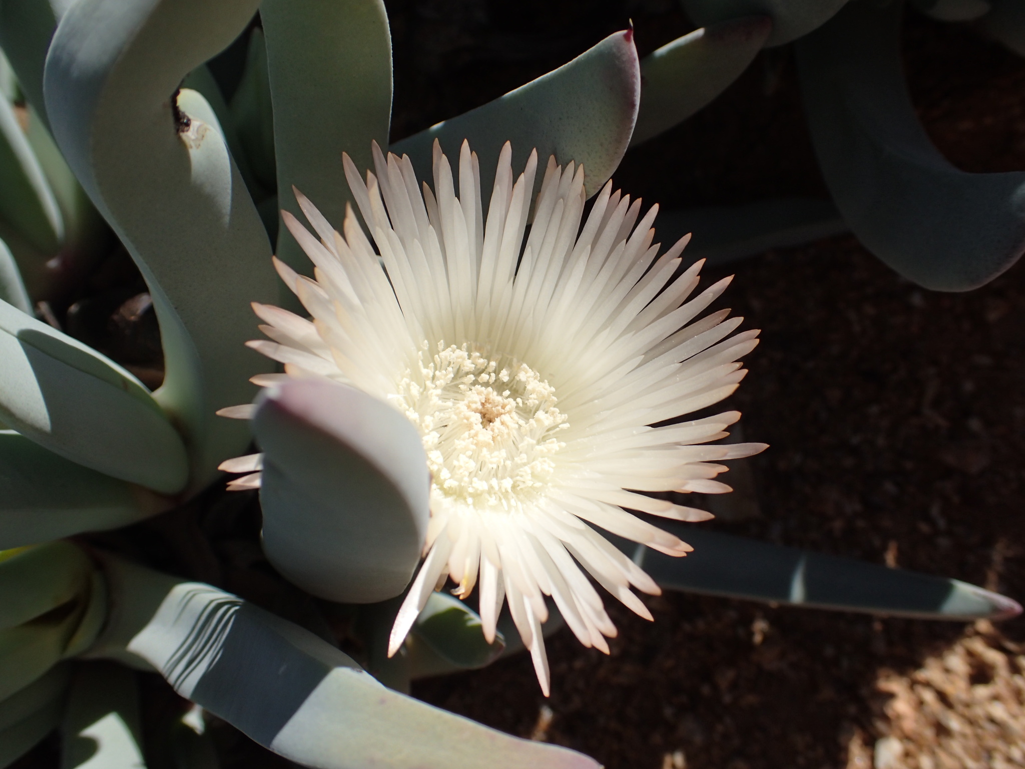
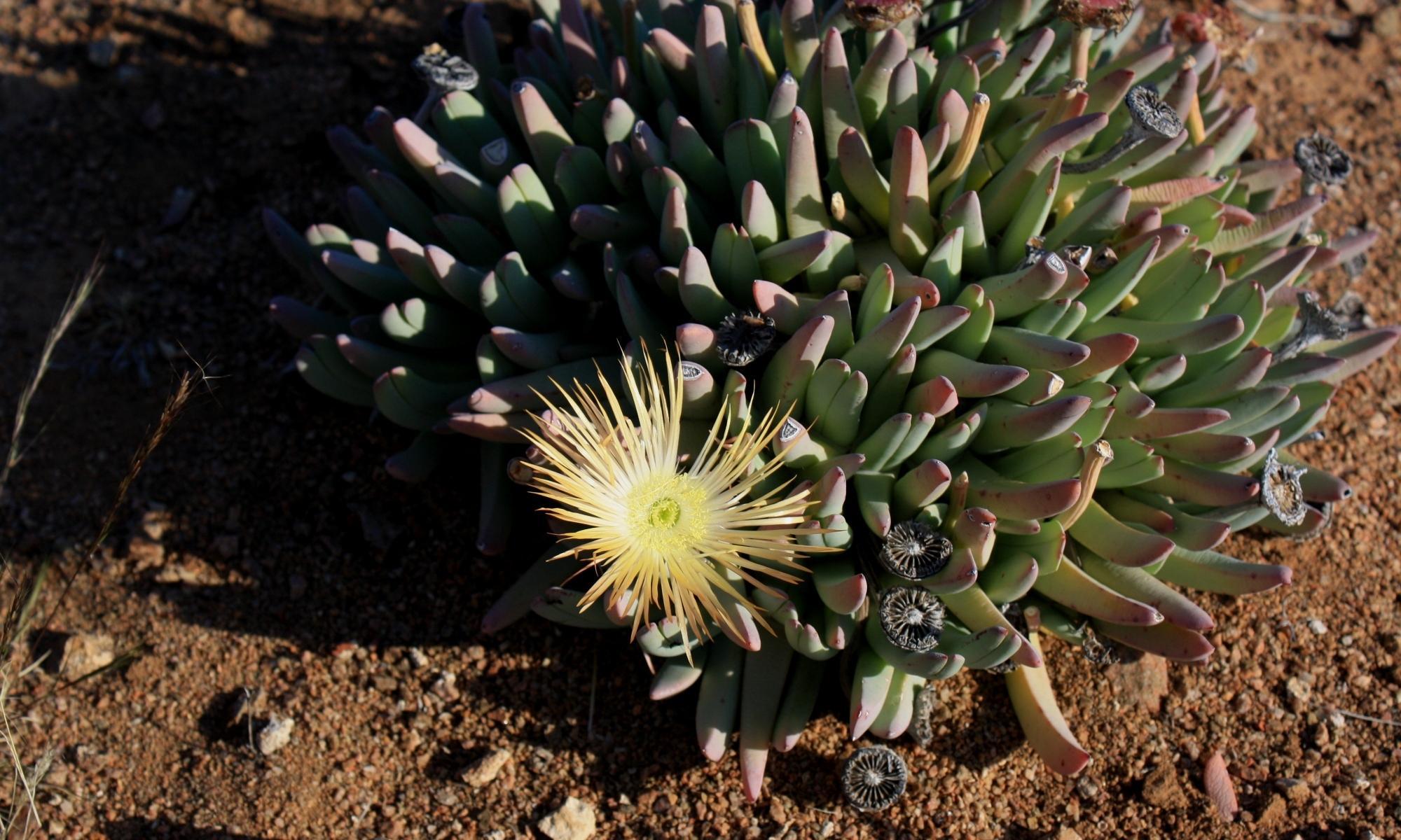
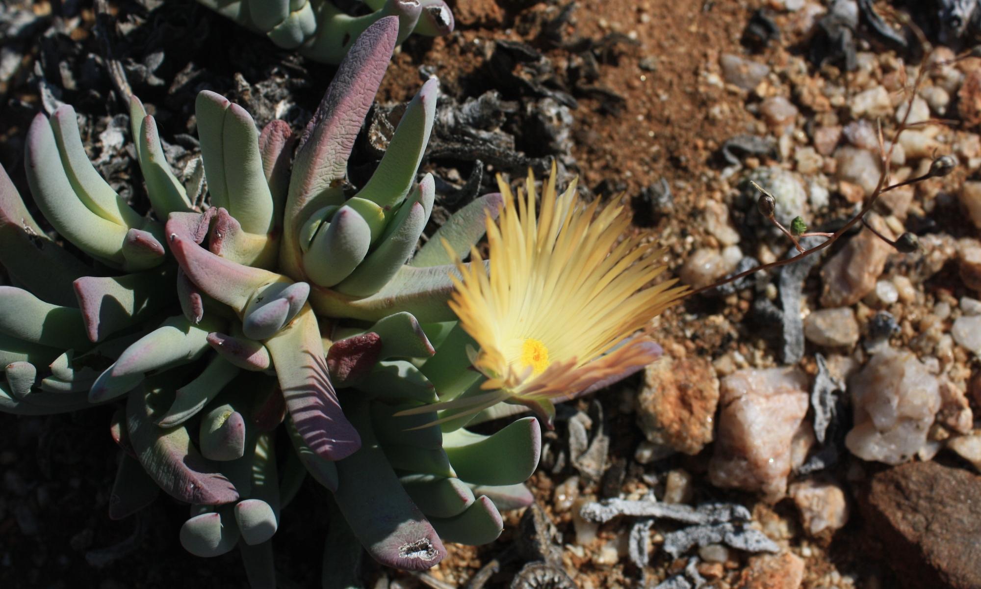
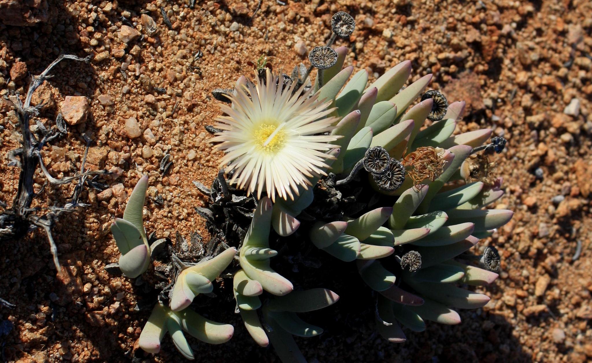
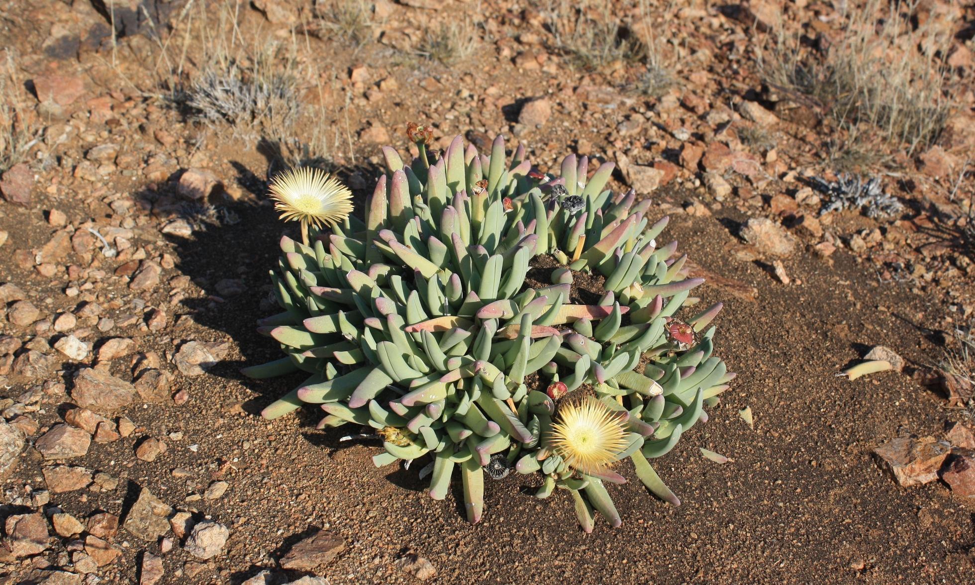
Succulent shrub, old plants densely clumped, 100-250 mm tall, up to 400 mm diam., not deciduous. Leaf-pairs forming a gaping V, each leaf flaring to tip, unequally toothed (absent one year but fiercely present the next), pale bluish grey to silvery white, never brownish, rarely green, subtly mottled. Flowers solitary, huge, long- and sturdily-stalked, petals pale yellow to cream or white with a rosy tinge. Fruit 12-20-locular. From: Hammer, SA. 2013. Aizoaceae: Cheiridopsis. In: DA Snijman (ed.), Plants of the Greater Cape Floristic Region 2: The Extra Cape flora. Strelitzia 30: 183-185. South African National Biodiversity Institute, Pretoria. [CC BY]
On flats or slopes, ubiquitous. From: Hammer, SA. 2013. Aizoaceae: Cheiridopsis. In: DA Snijman (ed.), Plants of the Greater Cape Floristic Region 2: The Extra Cape flora. Strelitzia 30: 183-185. South African National Biodiversity Institute, Pretoria. [CC BY]
Lower Richtersveld to Bitterfontein. From: Hammer, SA. 2013. Aizoaceae: Cheiridopsis. In: DA Snijman (ed.), Plants of the Greater Cape Floristic Region 2: The Extra Cape flora. Strelitzia 30: 183-185. South African National Biodiversity Institute, Pretoria. [CC BY]
300 to 1200 m
This map contains point-based occurrences at different locations
Occurrence in the Flora of Southern Africa (FSA) countries and South African provinces. Residence status indicates if a taxon is indigenous, endemic, naturalised or invasive in a specific region. This data is based on specimen records and literature
FSA
SA
BOT
NAM
ESW
LES
WC
EC
NC
FS
GA
KZN
LP
MP
NW
Absent
Indigenous
Endemic
Naturalised
Invasive

Names and Sources
Published in: Gard. Chron., ser. 3, 79: 407 (1926)
Mesembryanthemum denticulatum Haw. var. candidissimum Haw.
Mesembryanthemum denticulatum Haw. var. canum Haw.
Mesembryanthemum denticulatum Haw. var. glaucum Haw.
Mesembryanthemum denticulatum Haw.
Published in: Observ. Mesembryanthemum 2: 149 (1795)
Cheiridopsis candidissima (Haw.) N.E.Br.
Published in: Gard. Chron., ser. 3, 79: 407 (1926)
Cheiridopsis denticulata (Haw.) N.E.Br. var. glauca (Haw.) N.E.Br.
Published in: Gard. Chron., ser. 3, 79: 407 (1926)
Cheiridopsis inconspicua N.E.Br.
Published in: Gard. Chron., ser. 3, 79: 407, 426 (1926)
Cheiridopsis macrophylla L.Bolus
Published in: Notes Mesembryanthemum [H.M.L. Bolus] 2: 300 (1931)
Cheiridopsis vanheerdei L.Bolus
Published in: J. S. African Bot. 27: 55 (1960)
Cheiridopsis littlewoodii L.Bolus
Published in: J. S. African Bot. 27: 264 (1961)
| Common name | Language | Reference/barcode | Published as |
|---|---|---|---|
| T'noutsie-amma | Afrikaans | Powrie, LW. 2004. Common names of Karoo plants. Strelitzia: . National Botanical Institute, Pretoria. |
Cheiridopsis candidissima (Haw.) N.E.Br. |
Classification
KINGDOM Plantae
SUBKINGDOM Phanerogamae
PHYLUM Anthophyta
ORDER Caryophyllales
FAMILY Aizoaceae
SUBFAMILY Ruschioideae
TRIBE Ruschieae
GENUS Cheiridopsis
SPECIES denticulata
51 results for Cheiridopsis denticulata (Haw.) N.E.Br.
Year
Barcode: PRE0577804-0 Collector(s) & number: Burgoyne, PM, 7285 | 1999-6-27
South Africa, Northern Cape, Namaqualand District. Springbok area, ±89km from Aggeneys East of Gouwsberg Veld Reserve (Hester Malan).
Data Resource: BODATSA View record
Barcode: PRE0856261-0 Collector(s) & number: Steyn, HM, 1579 | 2009-8-13
South Africa, Northern Cape, Namaqua National Park; Wildeperdehoek Pass; between old prison and Kanariesfontein turn-off.
Data Resource: BODATSA View record
Barcode: PRE0769560-0 Collector(s) & number: Burgoyne, PM, 11041 | 2007-11-2
South Africa, Northern Cape, Steinkopf; ± 15 km N of Steinkopf on slopes West of Kabinakop.
Data Resource: BODATSA View record
Barcode: PRE0414516-0 Collector(s) & number: Le Roux, A, 13 | 1973-11-21
South Africa, Northern Cape, NAMAKWALAND; NABABEEP; KLIPDAM GOLFBAAN 6 KM. VANAF NABABEEP
Data Resource: BODATSA View record
Barcode: NBG1459883-0 Collector(s) & number: Powell, RF, 009 | 2014-5-11
South Africa, Northern Cape, Kamieskroon. 3.7 km S of turnoff to Wasklip, alongside N7 road verge.
Data Resource: BODATSA View record
Barcode: PRE0413882-0 Collector(s) & number: Verdoorn, IC, PRE 54610 | 1937-7-
South Africa, Northern Cape, NAMAQUALAND; SPRINGBOK
Data Resource: BODATSA View record
Barcode: PRE0766307-0 Collector(s) & number: Hardy, DS, 1367 | --
Namibia, Witputz.
General notes: Flower pale yellow. Garden no: 14185.
Data Resource: BODATSA View record
Barcode: PRE0843520-0 Collector(s) & number: Burgoyne, PM, 11254(b) | 2007-12-6
South Africa, Northern Cape, 20.1 km N of Kamieskroon on Droëdap road.
General notes: Gravelly sand. Pink granite. Slope: none. Height: ± 3-5 cm. Low clusters of upright glaucous leaves densely borne.
Data Resource: BODATSA View record
Barcode: PRE0576369-0 Collector(s) & number: Burgoyne, PM, 8118 | 2001-2-5
South Africa, Northern Cape, Namaqualand District: Springbok area - North of Springbok on Bulletrap road past Vaalheuwel Farm.
General notes: Soil. Well-drained. Sand. White quartzite. Slope: none. Biotic effect: none seen. Common.
Data Resource: BODATSA View record
Barcode: PRE0848231-0 Collector(s) & number: Steyn, HM, 1592 | 2009-8-14
South Africa, Northern Cape, Namaqua National Park; 4x4 track between Kykokeis and Kookfontein.
General notes: Namaqualand Klipkoppe Shrubland. Slope: gentle. Bright yellow flowers.
Data Resource: BODATSA View record
Barcode: PRE0563433-0 Collector(s) & number: Burgoyne, PM, 7769 | 2000-1-1
South Africa, Northern Cape, Namaqualand District: Springbok. ± 5 km West of Springbok on road to Kleinsee.
General notes: Nama Karroo. Rocky succulent scrubland. Hilltop. Soil twixt bare rock. Well-drained. Gravel. Granite. Full sun. N-aspect. Gentle slope. Biotic effect: none seen. Succulent, ± 10 cm high. Caespitose forming clumps. Leaves glaucous. Rare.
Data Resource: BODATSA View record
Barcode: PRE0413881-0 Collector(s) & number: Dyer, RA, 3858 | 1937-7-27
South Africa, Northern Cape, NAMAQUALAND; GARIES DIST
Data Resource: BODATSA View record
Barcode: PRE0804431-0 Collector(s) & number: Pearson, HHW, 6432 | 1911-9-10
South Africa, Northern Cape, Namaqualand: Stinkfontein.
Data Resource: BODATSA View record
Barcode: PRE0656008-0 Collector(s) & number: Stirton, CH, 6144 | 1976-8-
South Africa, Western Cape, SOUTRIVIER; KNERSVLAKTE. PNBG NO. 21597
Data Resource: BODATSA View record
Barcode: PRE0770275-0 Collector(s) & number: Burgoyne, PM, 11012(b) | 2007-11-30
South Africa, Northern Cape, Namaqualand District. E of Springbok. Pegmatite domes 4.2 km E of Springbok on road to Pofadder.
Data Resource: BODATSA View record
Barcode: PRE0563441-0 Collector(s) & number: Burgoyne, PM, 7793 | 2000-1-31
South Africa, Northern Cape, Namaqualand District: Steinkopf area. ± 10 km NE of Steinkopf.
General notes: Lowland Succulent Karroo. Plain. Rocky soil. Well-drained. Gravel. White quartzite patches. Full sun. Slope: none. Biotic effect: none seen. Succulent, ± 5 cm high, caespitose with glaucous leaves. Common.
Data Resource: BODATSA View record
Barcode: PRE0577805-0 Collector(s) & number: Burgoyne, PM, 7401 | 1999-7-2
South Africa, Western Cape, Van Rhynsdorp District. Bitterfontein area, ±29km N of Bitterfontein.
General notes: Nama Karoo. Succulent scrubland. Hill slope. Stony soil. Well drained. Gravel. Lithology: granite. Gentle slope. E aspect. Biotic Effect: roadside. Succulent, forming clumps, ±20cm in height. Waxy blue/green leaves. Large light yellow flowers. Abundatly common in spots.
Data Resource: BODATSA View record
Barcode: PRE0748732-0 Collector(s) & number: Giess, JWH, 13875 | 1975-10-
Namibia, ORANJEMUND; OBIB BERGE; C 3KM FROM OBIB-WASSER PNBG 20449
General notes: Winter rainfall.
Data Resource: BODATSA View record
Barcode: PRE0769566-0 Collector(s) & number: Burgoyne, PM, 11031 | 2007-12-2
South Africa, Northern Cape, Springbok area, Namaqualand; ± 25 km N of Springbok on road to Steinkopf.
Data Resource: BODATSA View record
Barcode: PRE0843443-0 Collector(s) & number: Burgoyne, PM, 11560 | 2008-5-21
South Africa, Northern Cape, Namaqualand District; ± 8 km N of Vaalputs.
General notes: Rocky ridge on plain. Slope: none. Common in spots. Grazed by sheep. Height: ± 10-15 cm. Clumps with upright glaucous leaves.
Data Resource: BODATSA View record
Barcode: PRE0752079-0 Collector(s) & number: Bester, SP, 5903 | 2005-8-16
South Africa, Northern Cape, Namaqua National Park.
General notes: Biome: Succulent Karoo. Vegetation type: Lowland Succulent Karoo. Flowers yellow turning orange with age. Forming clumps.
Data Resource: BODATSA View record
Barcode: PRE0413883-0 Collector(s) & number: Dyer, RA, 3858 | 1937-7-27
South Africa, Northern Cape, NAMAQUALAND; GARIES
Data Resource: BODATSA View record
Barcode: PRE0578950-0 Collector(s) & number: Burgoyne, PM, 8720 | 2002-11-17
South Africa, Western Cape, Vanrhynsdorp District: ± 78 km NNE of Vanrhynsdorp, S of Kliprand.
General notes: Gentle slope. NW-aspect. Succulent, ± 10cm high, clustered, with upright leaves, glaucous capsules on long upright pedicel.
Data Resource: BODATSA View record
Barcode: PRE0754621-0 Collector(s) & number: Burgoyne, PM, 10347(b) | 2005-11-29
South Africa, Northern Cape, Richtersveld. E of Port Nolloth and S of Lekkersing; ± 10 km on Lekkersing road from Port Nolloth.
Data Resource: BODATSA View record
Barcode: PRE0576298-0 Collector(s) & number: Burgoyne, PM, 8137 | 2001-2-6
South Africa, Northern Cape, Namaqualand District: Springbok area. ± 25 km on road to Hondelklip Bay.
General notes: Soil. Well-drained. Gravel. Granite. Gentle slope. W-aspect. Biotic effect: roadside. Flowers absent, fruit upright capsules. Occasional.
Data Resource: BODATSA View record
Barcode: PRE0769552-0 Collector(s) & number: Burgoyne, PM, 11054 | 2007-11-2
South Africa, Northern Cape, Namaqualand District. Precisely 40 km S of Vioolsdrift.
Data Resource: BODATSA View record
Barcode: PRE0414515-0 Collector(s) & number: Rosch, MW, 221 | 1973-11-24
South Africa, Northern Cape, NAMAKWALAND; HESTER MALAN NATUURRESERVAAT
Data Resource: BODATSA View record
Barcode: PRE0804433-0 Collector(s) & number: Pearson, HHW, 4068 | 1909-7-15
South Africa, Northern Cape, Little Bushmanland; Slopes at Eenriet.
Data Resource: BODATSA View record
Barcode: PRE0754622-0 Collector(s) & number: Burgoyne, PM, 10335(b) | 2005-11-29
South Africa, Northern Cape, Namaqualand District. Kleinsee area; ± 7 km from Kleinsee on road to Springbok.
General notes: Slope: gentle. Low dense clumps with upright succulent glaucous leaves. Common in spots.
Data Resource: BODATSA View record
Barcode: PRE0588591-0 Collector(s) & number: Burgoyne, PM, 9498B | 2002-9-19
South Africa, Northern Cape, Namaqualand District: ± 3km south of Kamiesberg turn on Springbok/Gamoep Road.
General notes: Rounded boulders. Sandy gravel. Gentle slope. Forming dense clumps with upright glaucous leaves. Flowers absent, fruit present.
Data Resource: BODATSA View record
Barcode: PRE0754620-0 Collector(s) & number: Burgoyne, PM, 10327(b) | 2005-11-29
South Africa, Northern Cape, Namaqualand District. Springbok area (SW of Springbok ± 2 km E of Spektakel Pass).
General notes: Rhenosterveld. Slope: moderate. Height ± 10-15 cm including fruits. Forming low dense clumps with upright glaucous leaves. Common in spots.
Data Resource: BODATSA View record
Barcode: PRE0570463-0 Collector(s) & number: van Wyk, E, MSEW 922 | 1999-10-11
South Africa, Northern Cape, Open slope in Northern Springbok outskirts.
General notes: Open low Euphorbia-Mesemb shrubland. Mountain slope. Sand. Gravel. Sandstone. E - aspect. Slope: 5-15°. Herb. Plant height: 0.15m. Unpalatable.
Data Resource: BODATSA View record
Barcode: NBG0202327-0 Collector(s) & number: Desmet, PG, 541 | 1996-8-28
South Africa, Northern Cape, Namaqualand. "Aronegas border with Doornfontein, Soebatsfontein", mid-slope, S facing, 50 m NE of fence with Aronegas.
General notes: N of Jansekraal. Granite. Lowland Succulent Karoo of the Namaqualand coastal belt. Granite. Namaqualand broken veld transition. Well-drained, stony rocks and loam soil. Bedrock. S aspect. Caespitose leaf, succulent dwarf shrub. Frequent. Flowers present. Flowers yellow.
Data Resource: BODATSA View record
Barcode: PRE0565877-0 Collector(s) & number: Hilton-Taylor, C, 2157 | 1987-8-19
South Africa, Northern Cape, North slopes of Rooiberg above Buffelsrivier - on eastern approach to the Meselpad.
General notes: Namaqualand broken veld. Hillside. S, SW - aspect. Slope - 4°- 5°.
Data Resource: BODATSA View record
Barcode: NBG1459894-0 Collector(s) & number: Powell, RF, 034 | 2014-5-15
South Africa, Northern Cape, Namaqualand. On road just past Spektakel Mine towards Kleinzee.
Data Resource: BODATSA View record
Barcode: PRE0770358-0 Collector(s) & number: Burgoyne, PM, 11263(b) | 2007-12-6
South Africa, Northern Cape, Namaqualand District; ± 47 km N of Kamieskroon on Droëdap road.
General notes: Gravelly sand pockets on baserock. Slope: steep. Common in spots. Height: ± 5-8 cm. Upight glaucous leaves forming tense clumps.
Data Resource: BODATSA View record
Barcode: PRE0804432-0 Collector(s) & number: Pearson, HHW, 4072 | 1909-1-15
South Africa, Northern Cape, Little Bushmanland: Eenriet; On lower sandy slopes.
Data Resource: BODATSA View record
Barcode: PRE0757798-0 Collector(s) & number: Burgoyne, PM, 10303 | 2005-11-28
South Africa, Northern Cape, Namaqualand District. NE of Steinkopf on Steinkopf/Viooldrift road at T-junction to road turning to Henkries.
General notes: Gravelly sand. Pegmatite. Slope: none. Height ± 5-10 cm. Low caespitose clumps with upright glaucous leaves tipped with teeth - some of the population not so. Common in spots.
Data Resource: BODATSA View record
Barcode: PRE0804426-0 Collector(s) & number: Rood, E, PRE 61500 | 1926-2-
South Africa, Western Cape, Near van Rhynsdorp.
General notes: PHOTO. Det: N.E. Brown
Data Resource: BODATSA View record
Barcode: PRE0867637-0 Collector(s) & number: Steyn, HM, 1579 | 2009-8-13
South Africa, Northern Cape, Namaqua National Park; Wildeperdehoek Pass; between old prison and Kanariesfonein turn-off.
General notes: SANParks.
Data Resource: BODATSA View record
Barcode: PRE0770293-0 Collector(s) & number: Burgoyne, PM, 11129 | 2007-12-3
South Africa, Northern Cape, Steinkopf area. Anenous Pass (middle part), 14.5 km from Steinkopf.
General notes: Stony soil to rocky soil. Gravelly sand. Slope: moderate.
Data Resource: BODATSA View record
This map contains point-based occurrences at different locations
2017
PERIODICAL/JOURNAL
Inclusion of Ihlenfeldtia and Odontophorus in Cheiridopsis (Ruschioideae: Aizoaceae) and insights into generic and subgeneric circumscription in the Conophytum clade Powell, R.F.; Boatwright, J.S.; Klak, C.; Magee, A.R.Botanical Journal of the Linnean Society 184: 457-484
2013
SERIES CHAPTER
Aizoaceae: Cheiridopsis Hammer, SAIn: DA Snijman (ed.), Plants of the Greater Cape Floristic Region 2: The Extra Cape flora. Strelitzia 30: 183-185
South African National Biodiversity Institute, Pretoria
2001
1987
PERIODICAL/JOURNAL
Dehn, M; Hartmann, HEKOBotanische Jahrbücher für Systematik, Pflanzengeschichte und Pflanzengeographie 108:
1967
PERIODICAL/JOURNAL
Cheiridopsis candidissima (N.E.Br.) N.E.Br. Bolus, HML; Page, MMFlowering Plants of Africa 38: , t.1507
No results found for Cheiridopsis denticulata (Haw.) N.E.Br.
Status and criteria
LC
Assessor(s)
Plantae Coordinator
JOURNAL ARTICLE
Rebelo, T. 2001. Conebushes. Protea Atlas Project: Interim distribution map: Cape edition 3. 3:1-44
JOURNAL ARTICLE
Rebelo, T. 2001. Pincushions and allies. Protea Atlas Project: Interim distribution map: Cape edition 3. 2:1-37
| Part(s) of plant used | Use(s) | Reference |
|---|
Coming soon...
