Stachys tysonii Skan
NE Indigenous

Morphological description

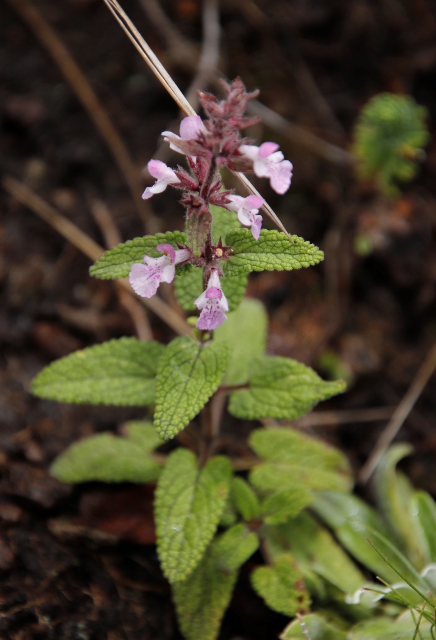
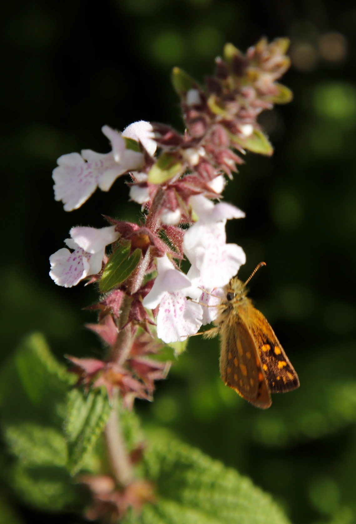
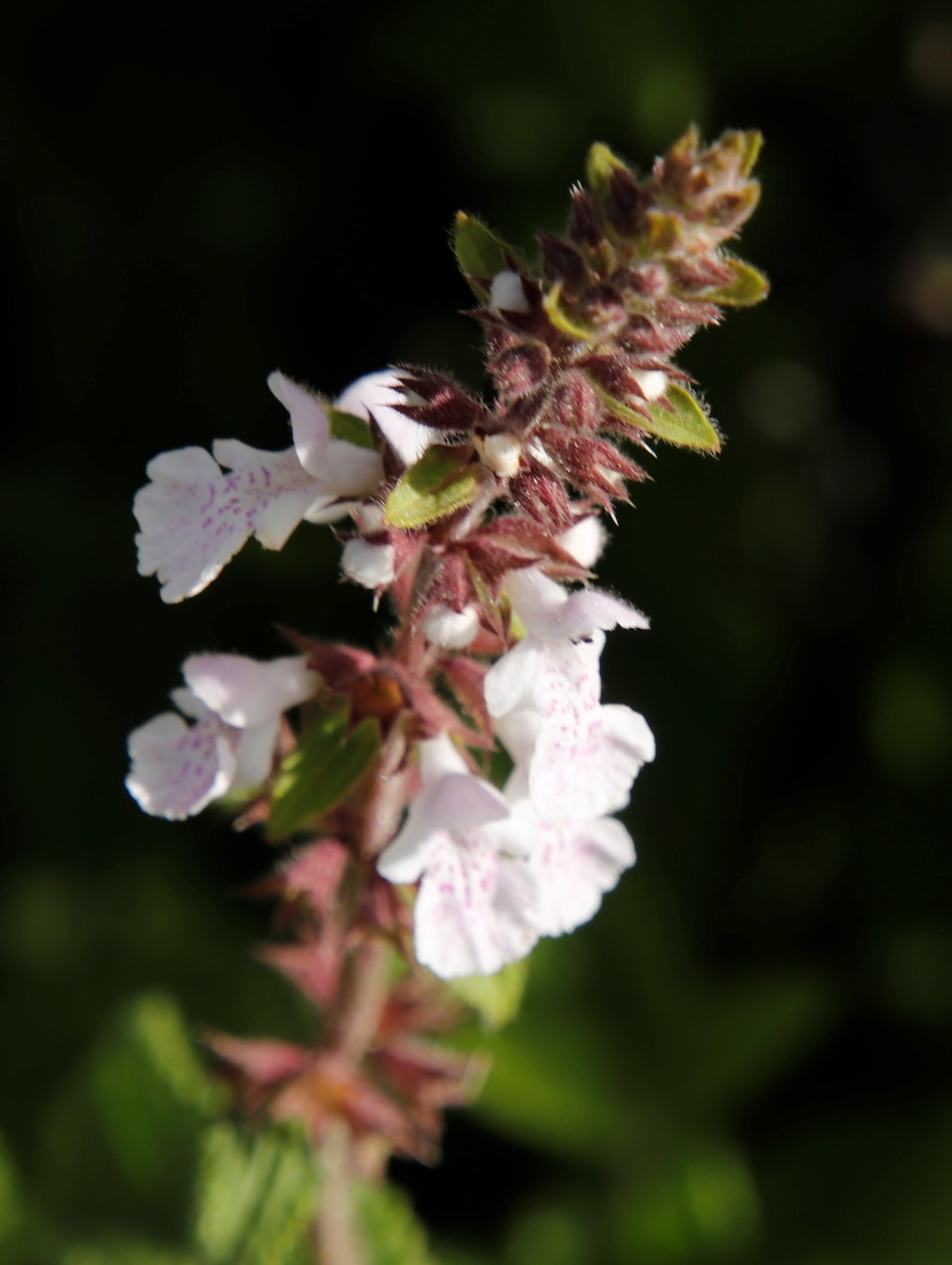
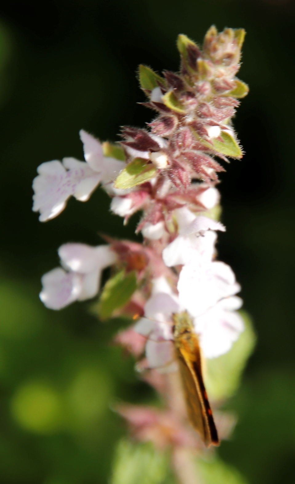
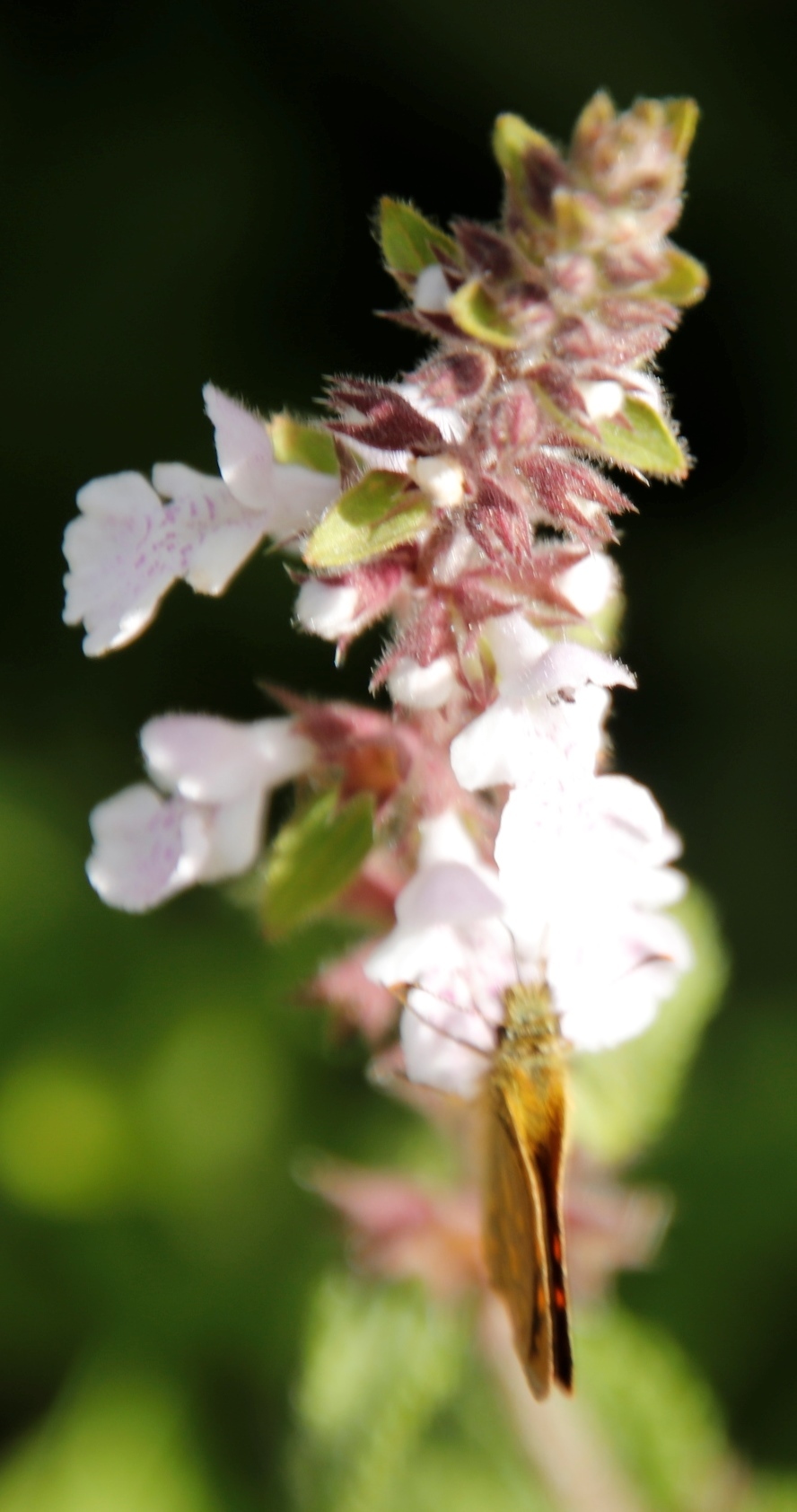
Perennial, few- to several-stemmed herb, 0.15-0.3 m tall; stems erect often from a decumbent base, sparingly branched, glandular-pilose with long slender hairs and short gland-tipped hairs. Leaves petiolate; blade drying green to brownish, ovate to ovate-lanceolate or ovate-oblong, 15-35 x 8-20 mm, upper surface softly to stiffly appressed pubescent, under-surface usually with copious gland-dots, apex rounded, base usually deeply cordate, margin regularly crenate-serrate; petiole 4-12 mm long. Inflorescence lax below, fairly dense above; verticils 4-6-flowered; bracts leaf-like below becoming smaller, lanceolate and subequal to the calyx above. Calyx shortly glandular-pubescent to glandular-pilose, 6-7 mm long. Corolla whitish to mauve with darker flecks on the lower lip; upper lip ascending, 2-3 mm long; lower lip de-flexed, 5-7 mm long. From: Codd, LEW. 1985. Lamiaceae: 13. Stachys. In: OA Leistner (ed.). Fl. S. Africa 28(4): 51-78. Botanical Research Institute, Department of Agriculture and Water Supply, Pretoria. [http://www.biodiversitylibrary.org/item/209555#page/9/mode/1up] [CC BY]

Perennial herb, 0.15-0.30 m high; few- to several-stemmed, erect often from decumbent base, sparingly branched, glandular-pilose with long slender hairs and short gland-tipped hairs. Leaves petiolate, ovate, ovate-lanceolate or ovate-oblong, 15-35 x 8-20 mm, base usually deeply cordate, apex rounded, margins regularly crenate-serrate; upper surface softly to stiffly appressed-pubescent, undersurface usually with copious gland dots. Inflorescence lax below, fairly dense above; verticillasters 4-6-flowered. Flowers whitish to mauve. Calyx shortly glandular-pubescent to glandular-pilose. Corolla: upper lip ascending; lower lip with darker flecks, deflexed. Flowering time Jan.-Apr. From: Bredenkamp, CL; Ngoepe, N. 2019. Lamiaceae. In: CL Bredenkamp (ed.), A Flora of the Eastern Cape Province. Strelitzia 41(2): 1125-1164. South African National Biodiversity Institute, Pretoria. [CC BY]

Perennial herb, up to 0.3 m high. Stems erect, stout, often from a decumbent base, glandular-pilose with long, slender hairs and short gland-tipped hairs. Leaves petiolate; blade ovate to narrowly ovate or ovate-oblong, 15-35 x 8-20 mm, apex rounded, base deeply cordate, margins regularly crenate-serrate, thick-textured, lower surface glandular-pubescent; petioles 4-12 mm long. Flowers: verticils 4-6-flowered; calyx 6-7 mm long, shortly glandular-pubescent to glandular-pilose; corolla whitish to mauve with darker flecks on lower lip, upper lip ascending, lower lip deflexed, 5-7 mm long; Nov.-Mar. From: Meyer, J; Retief, E; Meyer, NL. 2017. Lamiaceae. In: E Retief & NL Meyer (eds), Plants of the Free State: Inventory and identification guide. Strelitzia 38: 596-613. South African National Biodiversity Institute, Pretoria. [CC BY]

Diagnostic description

Related to S. obtusifolia, S. tysonii is distinguished by the longer petioles and more oblong cordate-based leaves, and by the generally shorter and more glandular pubescence over the whole plant. For example, the lower surface of the leaf is usually shortly and softly pubescent and freely gland-dotted. On this basis, S. obtusifolia var. angustifolia Skan is now included in S. tysonii. From: Codd, LEW. 1985. Lamiaceae: 13. Stachys. In: OA Leistner (ed.). Fl. S. Africa 28(4): 51-78. Botanical Research Institute, Department of Agriculture and Water Supply, Pretoria. [http://www.biodiversitylibrary.org/item/209555#page/9/mode/1up] [CC BY]

Habitat

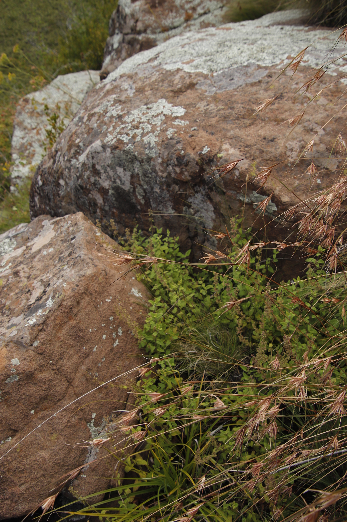
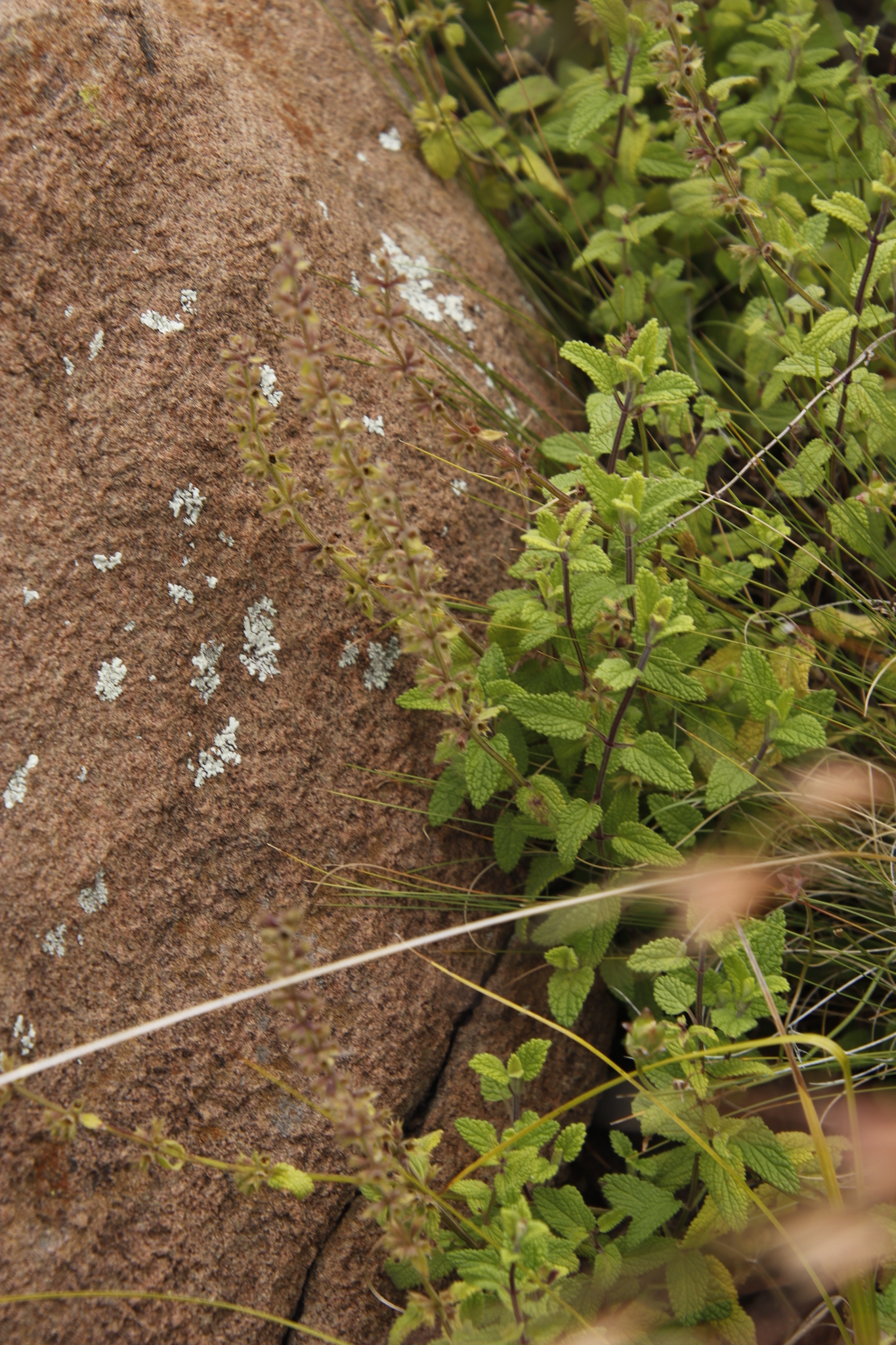
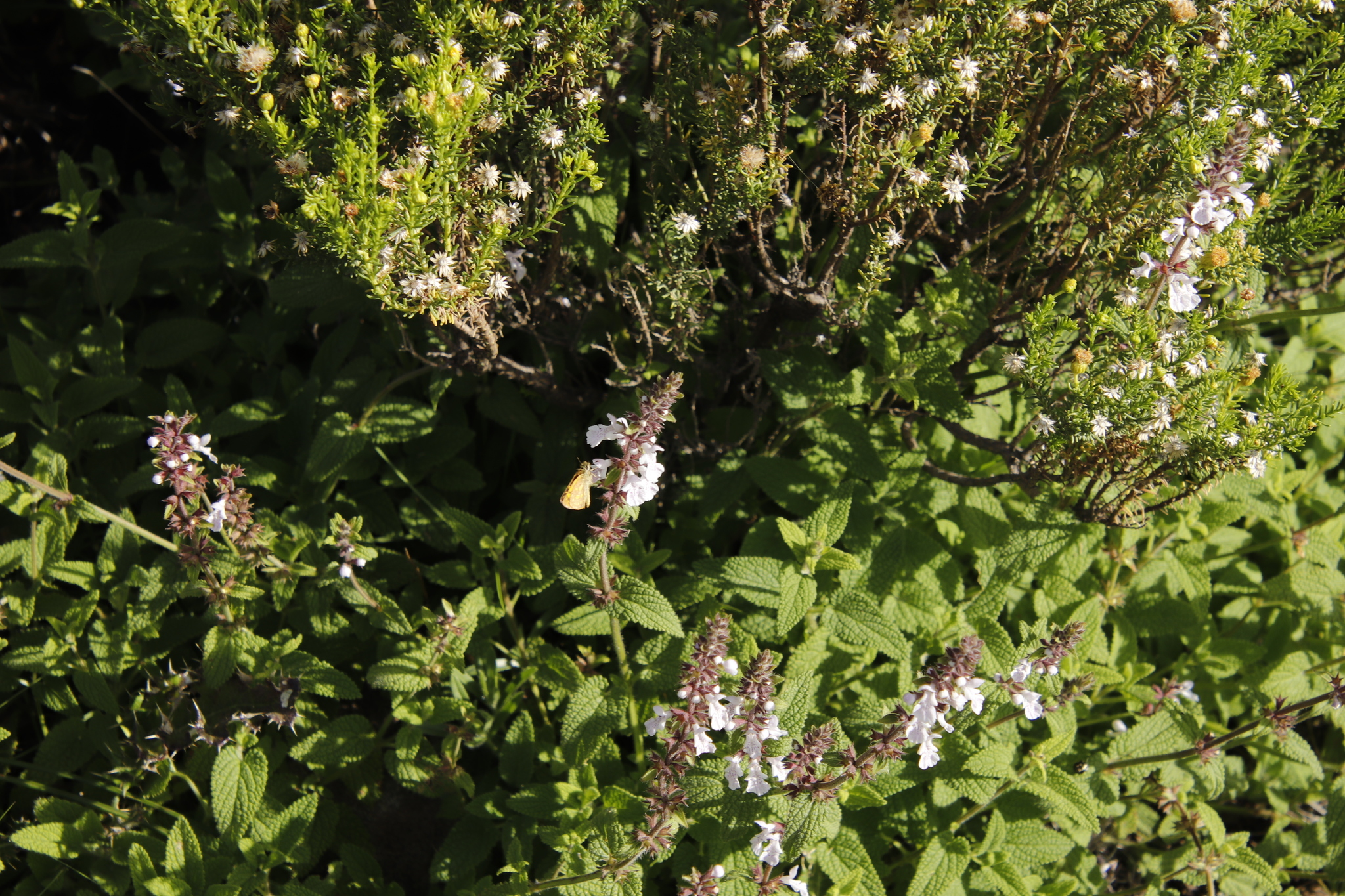
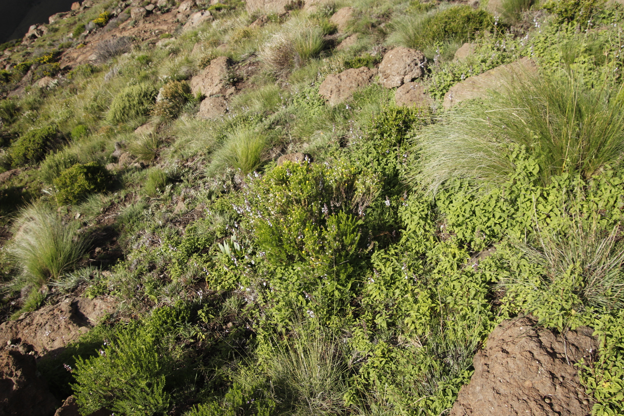
Found in mountain grassland. From: Codd, LEW. 1985. Lamiaceae: 13. Stachys. In: OA Leistner (ed.). Fl. S. Africa 28(4): 51-78. Botanical Research Institute, Department of Agriculture and Water Supply, Pretoria. [http://www.biodiversitylibrary.org/item/209555#page/9/mode/1up] [CC BY]

Mountain grassland, alt. 1000-2800 m; Drakensberg Grassland, Sub-Escarpment Grassland. From: Bredenkamp, CL; Ngoepe, N. 2019. Lamiaceae. In: CL Bredenkamp (ed.), A Flora of the Eastern Cape Province. Strelitzia 41(2): 1125-1164. South African National Biodiversity Institute, Pretoria. [CC BY]

Mesic Grassland. Mountain grassland. From: Meyer, J; Retief, E; Meyer, NL. 2017. Lamiaceae. In: E Retief & NL Meyer (eds), Plants of the Free State: Inventory and identification guide. Strelitzia 38: 596-613. South African National Biodiversity Institute, Pretoria. [CC BY]

Distribution

With scattered records from the Orange Free State, Natal, Lesotho and the Cape Province. From: Codd, LEW. 1985. Lamiaceae: 13. Stachys. In: OA Leistner (ed.). Fl. S. Africa 28(4): 51-78. Botanical Research Institute, Department of Agriculture and Water Supply, Pretoria. [http://www.biodiversitylibrary.org/item/209555#page/9/mode/1up] [CC BY]

Flowering time

November to March

Altitude

1000 to 2800 m

Occurrence records map

This map contains point-based occurrences at different locations

iNaturalist: BODATSA: Data partners records:

Residence status

Occurrence in the Flora of Southern Africa (FSA) countries and South African provinces. Residence status indicates if a taxon is indigenous, endemic, naturalised or invasive in a specific region. This data is based on specimen records and literature

FSA

SA

BOT

NAM

ESW

LES

WC

EC

NC

FS

GA

KZN

LP

MP

NW

Absent

Indigenous

Endemic

Naturalised

Invasive

https://seis-sanbi.azureedge.net/anura/default/asset.do?preview=207862

Names and Sources

Accepted name
Stachys tysonii Skan
Synonym(s)

Stachys obtusifolia MacOwan var. angustifolia Skan


Classification

KINGDOM Plantae

SUBKINGDOM Phanerogamae

SUBFAMILY Lamioideae

GENUS Stachys

SPECIES tysonii

19 results for Stachys tysonii Skan

Specimen records

Barcode: PRE0237644-0 Collector(s) & number: Jacot-Guillarmod, CF, 1255 | 1949-1-2

Lesotho, LIKOLOBENG

Data Resource: BODATSA View record

Barcode: PRE0238296-0 Collector(s) & number: Dieterlen, A, 1011 | 1913-11-8

Lesotho, LERIBE DIST; PITSENG; SLOPE

Data Resource: BODATSA View record

Barcode: PRE0237646-0 Collector(s) & number: Hilliard, OM, 6672 | 1971-2-21

South Africa, Eastern Cape, EASTERN CAPE; BARKLY EAST DIV.; RHODES TO NAUDES NEK

Data Resource: BODATSA View record

Barcode: PRE0681863-0 Collector(s) & number: Phillipson, PB, 1392 | 1986-3-28

Lesotho, OXBOW AREA.; MOTENG PASS.; W SIDE OF PASS. SHELTERED VALLEY.

Data Resource: BODATSA View record

Barcode: PRE0237645-0 Collector(s) & number: Acocks, JPH, 20198 | 1959-1-15

South Africa, Eastern Cape, SAALBOOM NEK

Data Resource: BODATSA View record

Barcode: PRE0999220-0 Collector(s) & number: Cingo, P, 50 | 2010-11-29

South Africa, KwaZulu-Natal, Estcourt District. Drakensberg. Injasuthi. Ridge opposite Grindstone Cave, south end of Cataract Valley.

Data Resource: BODATSA View record

Barcode: PRE0651189-0 Collector(s) & number: Roux, JP, 1734 | 1984-1-9

South Africa, Eastern Cape, OTTO DU PLESSIS PASS

Data Resource: BODATSA View record

Barcode: PRE0648793-0 Collector(s) & number: De Kruif, APM, 1099 | 1983-11-12

Lesotho, GOD HELP ME PASS; (MOLIMO-NTHUSE), BETWEEN BUSHMEN'S PASS AND BLUE MOUNTAIN PASS

Data Resource: BODATSA View record

Barcode: NH0143612-0 Collector(s) & number: Cingo, P, 50 | 2010-11-29

South Africa, KwaZulu-Natal, Estcourt District; Drakensberg; Injasuthi. Ridge opposite Grindstone Cave; south end of Cataract Valley.

Data Resource: BODATSA View record

Barcode: PRE0690365-0 Collector(s) & number: Phillipson, PB, 1372 | 1986-3-27

South Africa, Cape Province, LESOTHO; MOLIMO - NTHUSE PASS; W SIDE OF PASS

Data Resource: BODATSA View record

Barcode: PRE1003606-0 Collector(s) & number: De Kruif, APM, 1099 | 1983-11-12

Lesotho, Maseru, God help me-Pass (Molimo-Nthuse), between Bushmen's Pass and Blue Mountain-Pass.

Data Resource: BODATSA View record

Barcode: PRE0236636-0 Collector(s) & number: Acocks, JPH, 23875 | 1967-4-16

South Africa, Eastern Cape, BARKLY EAST DIV.; FASKALLY; BELOW MT. NEWTON

Data Resource: BODATSA View record

Barcode: PRE0237641-0 Collector(s) & number: Flanagan, HG, 1898 | 1893-12-

South Africa, Free State, WITSIESHOEK

Data Resource: BODATSA View record

Barcode: PRE1005522-0 Collector(s) & number: Morgenthal, TL, 930 | 2012-2-10

South Africa, Eastern Cape, Goatfell; Rhodes.

Data Resource: BODATSA View record

Barcode: PRE0237640-0 Collector(s) & number: Bolus, H, 8240 | 1893-12-

South Africa, Free State, WITSIESHOEK DIST.; BESTERVLEI; IN MT.

Data Resource: BODATSA View record

Barcode: PRE0237643-0 Collector(s) & number: Nicholson, HB, 1320 | 1973-11-6

South Africa, KwaZulu-Natal, IZINGOLWENI; HORSESHOE DAM

Data Resource: BODATSA View record

Observation records

Date: 2/7/2022 1:32:00 PM

Eastern Cape

Data Resource: iNaturalist View record

Date: 2/9/2022 1:48:00 PM

Eastern Cape

Data Resource: iNaturalist View record

Date: 2/8/2022 5:09:00 PM

Eastern Cape

Data Resource: iNaturalist View record

Plant occurence records per dataset

Plant occurence records per year

Occurrence records map

This map contains point-based occurrences at different locations

iNaturalist: BODATSA: Data partners records:

2019

SERIES CHAPTER

Lamiaceae Bredenkamp, CL; Ngoepe, N

In: CL Bredenkamp (ed.), A Flora of the Eastern Cape Province. Strelitzia 41(2)1125-1164

South African National Biodiversity Institute, Pretoria

2017

SERIES CHAPTER

Lamiaceae Meyer, J; Retief, E; Meyer, NL

In: E Retief & NL Meyer (eds), Plants of the Free State: Inventory and identification guide. Strelitzia 38: 596-613

South African National Biodiversity Institute, Pretoria

1985

FLORA CHAPTER

Lamiaceae: 1. Ajuga Codd, LEW

In: OA Leistner (ed.). Flora of Southern Africa 28(4)7-8

Botanical Research Institute, Department of Agriculture and Water Supply, Pretoria

1985

FLORA CHAPTER

Lamiaceae: 13. Stachys Codd, LEW

In: OA Leistner (ed.). Flora of Southern Africa 28(4)51-78

Botanical Research Institute, Department of Agriculture and Water Supply, Pretoria

No results found for Stachys tysonii Skan

Status

Global

Status and criteria

NE

Assessment date

2016-11-30

Assessor(s)

Plantae Coordinator

Distribution

Range

<p>The African Clawless Otter is the most widely distributed otter species in Africa, with a range extending from Senegal and Mali throughout most of West Africa to Sudan and Ethiopia, and then southwards throughout East Africa to the Western Cape of South Africa. They are absent from the Congo basin, where they are replaced by the Congo Clawless Otter (<em>Aonyx congicus</em>), the two species being sympatric in Uganda and Rwanda (Somers and Nel 2013). In Benin its distribution is limited to the extreme north along the Niger and Mekrou Rivers and is also reported from the Pendjari Park, but observations are extremely rare (Neuenschwander et al. 2011). </p>

Habitat and ecology

Major system

Freshwater

Major habitats

Cape Clawless Otters are predominantly aquatic and seldom found far from permanent water. Fresh water is an essential habitat requirement, not only for drinking but also for rinsing their fur. As otters do not have a subcutaneous layer of fat like most other aquatic mammals, they rely on their dense fur for thermoregulation. Thus, rinsing their fur in freshwater followed by rolling in sand, grass or reeds helps them cleanse their fur and restore the thermoregulatory properties. Generally, they will only occur in marine habitats provided there is access to fresh water (coastal rivers or estuaries) and rocky shores are preferred for foraging (van Niekerk et al. 1998), and otter activity is often found near thick vegetation, abundant food supply and fresh water (van der Zee 1982; Arden-Clarke 1986; van Niekerk et al. 1998). Elsewhere, they are found in diverse habitats, from impoundments, estuaries, and mangroves to desert conditions of the upper Doring River in the Western Cape and the Fish River in southern Namibia (Nel &amp; Somers 2007; Somers &amp; Nel 2013); they are also found in many seasonal or episodic rivers in the Karoo, such as the Sak, Vis, Riet, Seekoei and Gamka Rivers, provided suitable-sized pools persist (Nel &amp; Somers 2007; Somers &amp; Nel 2013; Prinsloo 2014). They have been recorded up to 2,900 m asl in the Lesotho Highlands (Lynch 1994; Avenant &amp; du Plessis 2012). Cape Clawless Otters have been found in towns and cities, and can occupy rivers with high pollution and eutrophication levels (Somers &amp; Nel 2013). <br/><br/>Somers and Nel (2004) found that in a river ecosystem, otters selected habitat characterised by reed beds,&#160; boulders and overhanging vegetation. It has also been found by other authors including Rowe-Rowe (1992a, 1992b) and Perrin and Carugati (2000), that Cape Clawless Otter activity is usually associated with natural riverine habitat, particularly with rocks covered with dense vegetation and large areas of undisturbed long grasses and dense bushes. Kubheka et al. (2013) found less otter sign in areas without stream-bank cover. Deforestation, overgrazing and the deterioration of riparian vegetation is therefore a threat to the key habitat requirements for the species in a river environment. <br/><br/>Cape Clawless Otters are predominantly crepuscular, meaning they are mostly active at dawn and dusk (Somers &amp; Nel 2004). However, this behaviour may differ between disturbed and non-disturbed habitats. In the protected areas of Drakensberg in KwaZulu-Natal they are often seen foraging from mid-afternoon. In the Cape Peninsula and Gauteng, for example, otters are more nocturnal in the urban areas possibly so as to avoid dogs, people and disturbance. <br/><br/>With a wide variety of prey items (for example, Rowe-Rowe 1977; Somers &amp; Purves 1996; Jordaan et al. 2015), this species shows functional responses to temporal or geographical patterns, and can switch between prey items (for example, between fish, crabs, frogs, insects or combinations thereof), thus facilitating a wide distribution (Nel &amp; Somers 2007). <br/><br/>Arden-Clarke (1986) estimated the home range of otters in Tsitsikamma National Park, Eastern Cape of South Africa, and found the minimum home range for a female otter to be 14.3 km (7.5 km core range), and for a male otter to be 19.5 km (12 km core range). In the Western Cape, the home range of otters in rivers was estimated by Somers and Nel (2004). They found that total range length varied from 4.9–54.1 km (linear home range core length from 0.2–9.8 km). The pattern of home range use by females was suggestive of territoriality. Male Cape Clawless Otters had overlapping home ranges in both studies (Arden-Clarke 1986; Somers &amp; Nel 2004), with other males and with females.).<br/><br/><strong>Ecosystem and cultural services:</strong> Globally, other otter species are considered to be indicators of water quality—for example, in both North American rivers (North American River Otter <em>Lontra canadensis</em>) (Mayack 2012) and coastlines (Sea Otter<em> Enhydra lutris</em>) (Jessup et al. 2004)—or sentinels of environmental health; for example, in Europe (European Otter<em> Lutra lutra</em>) (Chadwick 2007; Lemarchand et al. 2011). Mayack (2012) suggested that the otter’s wide distribution, opportunistic and predatory nature, plus their flexibility in habitat and diet, allow them to serve as a useful upper level consumer component in ecosystem monitoring. Similarly, the Cape Clawless Otter may be a useful flagship species to highlight the importance of river health, and potentially provide information on the contaminant levels in African urban rivers as European Otters do in Europe. However, it is not yet known whether Cape Clawless Otters have an important role in the freshwater ecosystems. Currently, research is underway investigating the health of otters relative to the pollution levels in urban rivers (N. C. Okes unpubl. data). Preliminary results show that certain persistent organic pollutants are present in the tissues of otters found killed on the roads in the Cape Peninsula (N. C. Okes unpubl. data). Further research is needed in order to establish whether they may be a useful indicator species for river health (see, for example, Seaman et al. 2010; Prinsloo 2014). <br/><br/>In the Lesotho Highlands, inhabitants report that Cape Clawless Otters are commonly used for traditional medicine, clothes, hats, and as food (Avenant 2004).

Threats

There are no major threats to the species within the assessment region. However, in some parts of their range, their habitat has been either drastically changed or lost, following bush clearing, deforestation, overgrazing, siltation, expansion of human settlements, draining of wetlands, water extraction or denudation of riparian vegetation (Rowe-Rowe 1995; Nel et al. 2007; CSIR 2010).

In KwaZulu-Natal, Rowe-Rowe (1992b) identified the primary threat as the increasing human population, leading to adverse alteration of freshwater habitats and riparian vegetation. Negative effects usually arise from increased agricultural activity, such as overgrazing with increased soil run-off, and commercial afforestation (for example, Jewitt et al. 2015). Acid pollution from coal mining, pesticides from farmlands and waste from urban landfill sites are also observed as a threat (Mason & Rowe-Rowe 1992; N. C. Okes pers. obs. 2015). Urban expansion and industrialisation are responsible for the pollution of streams and rivers and for the loss of habitat. However, the impacts of habitat loss, increased riparian activity and disturbance on otter populations are largely unknown. A recent study compared otter sign surveys at a location in the Drakensberg in 1972–1974, 1993–1994 and in 2012 (Kubheka et al. 2013). They found that the signs of otters along this site had largely been reduced since earlier surveys (by 75% for the Cape Clawless Otter), and speculate that human population growth and increased riparian activity was having a negative impact on otter presence in this location in the Drakensberg (Kubheka et al. 2013). Internationally, increases in pollution have led to a dramatic decrease in local otter populations (Kruuk 2006). Current research on otters in the Cape Peninsula has found that certain persistent organic pollutants are present in the tissue of otters in urban areas (N. C. Okes unpubl. data). More research however is required on the effects of pollution on otters and their associated sources of food in South Africa as there is a gap in knowledge relating to the threat faced by otters from degradation of riparian areas. Occupancy modelling in the Cape Peninsula across a transformed landscape suggests that otters can tolerate certain levels of human impact and can inhabit areas in close proximity to roads (although road collisions are a threat in these areas) and in areas of high human population density (N. C. Okes unpubl. data).

Analysis of habitat use within rivers, however, suggests a higher probability that otters prefer non-canalised sections of river that are not heavily polluted (N. C. Okes unpubl. data). More data regarding the level of degradation of riparian areas the otters can successfully tolerate is needed. Research in South America has shown that the Southern River Otter (Lontra provocax) is able to tolerate moderate levels of change to riverbank vegetation so long as there is very little human activity along the floodplain (Medina-Vogel et al. 2003).

In the Lesotho Highlands, the impacts of dogs and cattle herders are expected to be less on otters than on most other mammals along rivers, due to the otter’s ability to escape in and through the water, and their nocturnal activity patterns (Avenant 2004; Avenant & du Plessis 2012). Higher up in the mountains, where streams are smaller/easier to cross, dogs may be a threat (N.L. Avenant pers. obs.). Other predicted threats in the Highlands are overgrazing of riverbanks, and the burning of riverbanks and wetland areas (for grazing). Occasionally, they are accidentally caught and drowned in gill nets and fish traps (Rowe-Rowe 1990).

Another problem arising from human activity along rivers is pollutants entering rivers causing some species in the rivers to die-off, leading to a decrease in the biotic diversity of the rivers (Grimm et al. 2008), ultimately resulting in a shift in predator-prey dynamics. More research is required on the potential impacts pollution and climate change may have on the otter’s prey base. No research has yet been conducted on the threshold for Cape Clawless Otter survival along disturbed rivers.

Population

Population trend

Density estimates from various studies in southern Africa are summarised by Somers and Nel (2013). Within the assessment region, the following density estimates are available: in Tsitsikamma Coastal National Park in the Eastern Cape Province, density has been calculated as 1 otter / 2 km of coast (van der Zee 1982; Arden-Clarke 1986). Verwoerd (1987) similarly estimated 1 otter / 2 km of coast at Betty’s Bay in the Western Cape. Using signs such as spoor, estimates of density in freshwater habitats in the Drakensberg, KZN, have been estimated as 1 otter / 1.25–2.5 km (Carugati 1995; Perrin &amp; Carugati 2000), 1 otter / 3–4 km (Rowe-Rowe 1992a), and 1 otter / 2.5 km (Carugati &amp; Perrin 2006). In eastern Zimbabwe the estimate is 1 otter / 8–10 km of river (Butler &amp; du Toit 1994). Based on the recovery of radioactive scats, Somers (2001) gives an estimate of 1.5 individuals / km of river. Although reported widely in Lesotho, especially in the Lesotho Highlands, no density estimates are known. Instead, densities of latrine sites are commonly reported on during environmental impact assessments (for example, du Plessis et al. 2014). <br/><br/>In the previous assessment, a population size of 14,000 individuals was calculated from 26,000 km of river and 2,000 km of coast (density estimated at 1 individual / 2 km river or coast) (Friedmann &amp; Daly 2004). We estimate 53,475 km of river (and 2,140 km of coastline) within its range, of which 24,679 km of river can be considered disturbed and 28,796 km less disturbed using National Freshwater Ecosystem Priority Area land cover data (Nel et al. 2011). For mature population structure, although further empirical data are needed, Van der Zee (1982) estimated the adult to juvenile ratio as 55–64% (22 adults, 18 juveniles; and 16 adults, nine juveniles, respectively) in Tsitsikamma National Park. Using density estimates of 0.25 otter / km of disturbed river (Rowe-Rowe 1992a), 0.8 otter / km of less-disturbed river (Carugati &amp; Perrin 2006) and 0.5 otter / km of coastline (Verwoerd 1987) yields an estimated population size of 30,276 individuals (16,552– 19,377 mature). Using the lowest density estimate for disturbed rivers (0.1 otter / km river; Butler &amp; du Toit 1994) yields 26,574 individuals (14,616–17,007 mature). Similarly, using average density estimates for freshwater habitats from the Drakensberg (0.44 otter / km river) for total river length yields a total population of 24,465 individuals (13,456–15

Bibliography

RLDB
Pinhey, E. 1961. A survey of the dragonflies of Eastern Africa

JOURNAL ARTICLE
Dijkstra, K.-D.B. and Clausnitzer, V. 2014. The Dragonflies and Damselflies of Eastern Africa: Handbook for all Odonata from Sudan to Zimbabwe.. Studies in Afrotropical Zoology. 298:1-264

Part(s) of plant used Use(s) Reference

Coming soon...